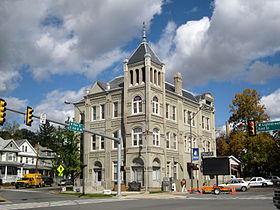
Bloomsburg Historic District
Appearance
Bloomsburg Historic District | |
 Bloomsburg Chamber of Commerce, April 2007 | |
| Location | Roughly bounded by Penn, 5th, West, Willow, Millville and Light Sts., Bloomsburg, Pennsylvania |
|---|---|
| Coordinates | 41°00′09″N 76°27′13″W / 41.00250°N 76.45361°W |
| Area | 158 acres (64 ha) |
| Built | 1845 |
| Architect | Multiple |
| Architectural style | Colonial Revival, Mixed (more Than 2 Styles From Different Periods) |
| NRHP reference No. | 83002229[1] |
| Added to NRHP | September 8, 1983 |
Bloomsburg Historic District is a national historic district located at Bloomsburg, Columbia County, Pennsylvania, USA. The district includes 668 contributing buildings, 1 contributing site, and 1 contributing object in the central business district and surrounding residential areas of Bloomsburg. Notable non-residential buildings include the Carver Hall at the Bloomsburg University of Pennsylvania (c. 1867), Courthouse, town hall, and St. Paul's Episcopal Church.[2]
It was added to the National Register of Historic Places in 1983.[1]
-
Courthouse
-
Town Hall
-
Downtown
-
Caldwell Consistory
References
[edit]- ^ a b "National Register Information System". National Register of Historic Places. National Park Service. July 9, 2010.
- ^ "National Historic Landmarks & National Register of Historic Places in Pennsylvania". CRGIS: Cultural Resources Geographic Information System. Archived from the original (Searchable database) on July 21, 2007. Retrieved January 21, 2012. Note: This includes Marnie Crouch (December 1982). "National Register of Historic Places Inventory Nomination Form: Bloomsburg Historic District" (PDF). Retrieved January 21, 2012.
Wikimedia Commons has media related to Bloomsburg Historic District.


