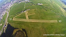
Nowy Targ Airport
Appearance
Nowy Targ Airfield Lotnisko Nowy Targ | |||||||||||
|---|---|---|---|---|---|---|---|---|---|---|---|
| Summary | |||||||||||
| Airport type | Public | ||||||||||
| Operator | Aeroklub Nowy Targ | ||||||||||
| Serves | Nowy Targ, Zakopane | ||||||||||
| Location | Nowy Targ | ||||||||||
| Elevation AMSL | 627 m / 2,060 ft | ||||||||||
| Coordinates | 49°27′45″N 20°03′01″E / 49.46250°N 20.05028°E | ||||||||||
| Runways | |||||||||||
| |||||||||||

Nowy Targ Airport is a grass airfield serving Nowy Targ, Podhale, Poland, opened in 1930.[1] In 1962 LOT Polish Airlines commenced a scheduled service between Nowy Targ and Warsaw, but this was terminated after 10 flights when it was decided to discontinue the use of grass airfields.[1][2]
References
[edit]- ^ a b Szlezynger, Piotr S. (2006). "Lotnisko w Nowym Targu wartością dziedzictwa kulturowego" (PDF). Folia Turistica. 17: 51–76.
- ^ Fularz, Adam (2018). LOT i obsługa połączeń pasażerskich. Tom I. Merkuriusz Polski. p. 62. ISBN 9788364326134.
