[ 3] Name on the Register[ 4]
Image
Date listed[ 5]
Location
City or town
Description
1
A. J. Meerwald A. J. Meerwald November 7, 1995 (#95001256 ) 22 Miller Avenue on Maurice River 39°14′05″N 75°01′50″W / 39.234722°N 75.030556°W / 39.234722; -75.030556 (A. J. Meerwald Commercial Township Delaware Bay oyster schooner
2
Beth Hillel Synagogue Beth Hillel Synagogue November 7, 1978 (#78001755 ) 547 Irving Ave, Carmel 39°26′03″N 75°07′31″W / 39.434167°N 75.125278°W / 39.434167; -75.125278 (Beth Hillel Synagogue ) Deerfield Township
3
Bethel African Methodist Episcopal Church Bethel African Methodist Episcopal Church November 12, 1999 (#99001312 ) Sheppards Mill Rd. (Greenwich Township) 39°24′06″N 75°19′48″W / 39.401667°N 75.33°W / 39.401667; -75.33 (Bethel African Methodist Episcopal Church ) Greenwich Township
4
Bivalve Oyster Packing Houses and Docks Bivalve Oyster Packing Houses and Docks February 28, 1996 (#96000079 ) Shell Rd., Miller and Howard Sts., Commercial Township 39°14′00″N 75°01′56″W / 39.233333°N 75.032222°W / 39.233333; -75.032222 (Bivalve Oyster Packing Houses and Docks ) Commercial Township
5
Bridgeton Historic District Bridgeton Historic District October 29, 1982 (#82001043 ) Roughly bounded by RR Tracks, South Ave., Lake, Commerce, Water, Belmont, Cohensey, and Penn Sts. 39°25′41″N 75°13′57″W / 39.428056°N 75.2325°W / 39.428056; -75.2325 (Bridgeton Historic District ) Bridgeton
6
Jeremiah Buck House Jeremiah Buck House December 30, 1975 (#75001130 ) 297 E. Commerce St. 39°25′43″N 75°13′36″W / 39.428611°N 75.226667°W / 39.428611; -75.226667 (Jeremiah Buck House ) Bridgeton
7
Cashier Cashier February 23, 2016 (#15001050 ) 2800 High Street 39°14′00″N 75°02′02″W / 39.233232°N 75.033766°W / 39.233232; -75.033766 (Cashier Commercial Township Oyster schooner at the Bayshore Center at Bivalve .
8
Deerfield Pike Tollgate House Deerfield Pike Tollgate House May 21, 1975 (#75001131 ) 89 Old Deerfield Pike 39°27′09″N 75°13′45″W / 39.4525°N 75.229167°W / 39.4525; -75.229167 (Deerfield Pike Tollgate House ) Bridgeton Demolished in 2001.[ 6]
9
Deerfield Presbyterian Church Deerfield Presbyterian Church September 29, 1980 (#80002481 ) NE of Seabrook 39°30′42″N 75°14′17″W / 39.511667°N 75.238056°W / 39.511667; -75.238056 (Deerfield Presbyterian Church ) Seabrook
10
Gen. James Giles House Gen. James Giles House March 8, 1978 (#78001754 ) 143 W. Broad St. 39°25′44″N 75°14′33″W / 39.428889°N 75.2425°W / 39.428889; -75.2425 (Gen. James Giles House ) Bridgeton
11
Greenwich Historic District Greenwich Historic District January 20, 1972 (#72000772 ) Main St. from Cohansey River N to Othello 39°23′51″N 75°20′25″W / 39.3975°N 75.340278°W / 39.3975; -75.340278 (Greenwich Historic District ) Greenwich
12
Caesar Hoskins Log Cabin Caesar Hoskins Log Cabin September 10, 1987 (#87001521 ) Jct. of South and Second Sts. 39°17′02″N 74°59′41″W / 39.283916°N 74.994722°W / 39.283916; -74.994722 (Caesar Hoskins Log Cabin ) Mauricetown
13
Indian Head Site Indian Head Site October 27, 2004 (#04001196 ) Address restricted Deerfield Township
14
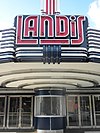
Landis Theatre–Mori Brothers Building Landis Theatre–Mori Brothers Building November 22, 2000 (#00001405 ) 830–834 Landis Avenue 39°29′10″N 75°01′03″W / 39.486111°N 75.0175°W / 39.486111; -75.0175 (Landis Theatre–Mori Brothers Building ) Vineland
15
Thomas Maskel House Thomas Maskel House June 10, 1975 (#75001132 ) 2 mi (3.2 km). West of Greenwich on Bacon's Neck Road 39°24′04″N 75°22′34″W / 39.401111°N 75.376111°W / 39.401111; -75.376111 (Thomas Maskel House ) Greenwich Township
16
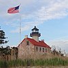
Maurice River Lighthouse and East Point Archeological District Maurice River Lighthouse and East Point Archeological District August 25, 1995 (#95001047 ) Lighthouse Road, near the junction of East Point Road 39°11′45″N 75°01′40″W / 39.195833°N 75.027778°W / 39.195833; -75.027778 (Maurice River Lighthouse and East Point Archeological District ) Maurice River Township
17
Mauricetown Historic District Mauricetown Historic District March 29, 2018 (#100002252 ) Roughly along Highland Street 39°17′10″N 74°59′43″W / 39.286111°N 74.995278°W / 39.286111; -74.995278 (Mauricetown Historic District ) Mauricetown Includes Caesar Hoskins Log Cabin
18
Miah Maull Shoal Lighthouse Miah Maull Shoal Lighthouse February 4, 1991 (#90002188 ) In Delaware Bay 5 mi (8.0 km). SW of Egg Island Point 39°07′36″N 75°12′35″W / 39.126667°N 75.209722°W / 39.126667; -75.209722 (Miah Maull Shoal Lighthouse ) Downe Township
19
Millville's First Bank Building Millville's First Bank Building November 20, 1980 (#80002480 ) 2nd and E. Main Sts. 39°23′43″N 75°02′14″W / 39.395278°N 75.037222°W / 39.395278; -75.037222 (Millville's First Bank Building ) Millville
20
Old Broad Street Presbyterian Church and Cemetery Old Broad Street Presbyterian Church and Cemetery December 2, 1974 (#74001159 ) Broad and Lawrence Sts. 39°25′44″N 75°14′46″W / 39.42896°N 75.24608°W / 39.42896; -75.24608 (Old Broad Street Presbyterian Church and Cemetery ) Bridgeton
21
Old Stone Church Old Stone Church May 12, 1977 (#77000860 ) N of Cedarville on NJ 553 39°21′37″N 75°13′30″W / 39.360278°N 75.225°W / 39.360278; -75.225 (Old Stone Church ) Fairfield Township Early Fairfield Presbyterian Church building
22
Potter's Tavern Potter's Tavern September 10, 1971 (#71000501 ) 49-51 Broad St. 39°25′40″N 75°14′20″W / 39.427778°N 75.238889°W / 39.427778; -75.238889 (Potter's Tavern ) Bridgeton
23
John and Elizabeth Remington House John and Elizabeth Remington House July 14, 2015 (#15000420 ) 689 Roadstown Road 39°26′24″N 75°18′41″W / 39.44006°N 75.31126°W / 39.44006; -75.31126 (John and Elizabeth Remington House ) Hopewell Township
24
Samuel W. Seeley House Samuel W. Seeley House May 13, 1976 (#76001150 ) 274 E. Commerce St. 39°25′41″N 75°13′37″W / 39.428056°N 75.226944°W / 39.428056; -75.226944 (Samuel W. Seeley House ) Bridgeton
25
Ship John Shoal Light Station Ship John Shoal Light Station July 19, 2006 (#06000630 ) In Delaware Bay, 3.3 mi (5.3 km). W-SW of Sea Breeze 39°18′26″N 75°22′36″W / 39.307222°N 75.376667°W / 39.307222; -75.376667 (Ship John Shoal Light Station ) Sea Breeze
26
Siloam Cemetery Siloam Cemetery April 3, 2020 (#100005155 ) 550 North Valley Avenue 39°29′22″N 75°00′24″W / 39.4895°N 75.0068°W / 39.4895; -75.0068 (Siloam Cemetery ) Vineland
26
Spindrift Sailing Yacht Upload image April 22, 1982 (#82003271 ) S. of Bridgeton 39°22′48″N 75°13′24″W / 39.38°N 75.223333°W / 39.38; -75.223333 (Spindrift Sailing Yacht ) Bridgeton Boat is no longer at this location.
27
Trinity African Methodist Episcopal Church Trinity African Methodist Episcopal Church September 29, 1995 (#95001138 ) Bridgeton-Milltown Rd. (NJ 49), E of Woodruff Rd. (Co. Rd. 553), Fairfield Twp. 39°25′12″N 75°11′03″W / 39.42°N 75.184167°W / 39.42; -75.184167 (Trinity African Methodist Episcopal Church ) Fairfield Township
28
Vineland High School Vineland High School March 3, 1995 (#95000181 ) 61 W. Landis Ave. 39°29′10″N 75°02′17″W / 39.486111°N 75.038056°W / 39.486111; -75.038056 (Vineland High School ) Vineland Now the Landis School.
29
Wood Mansion House Wood Mansion House December 24, 2013 (#13000975 ) 821 Columbia Avenue 39°24′10″N 75°02′42″W / 39.402841°N 75.045118°W / 39.402841; -75.045118 (Wood Mansion House ) Millville


