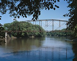
Bridgeport Bridge (Denmark, Iowa)
Bridgeport Bridge | |
 | |
| Location | Old Quarry Road |
|---|---|
| Nearest city | Denmark, Iowa |
| Coordinates | 40°47′25″N 91°21′50″W / 40.79028°N 91.36389°W |
| Area | less than one acre |
| Built | 1904 |
| Architect | Clinton Bridge and Iron Works |
| Architectural style | Pennsylvania through truss |
| MPS | Highway Bridges of Iowa MPS |
| NRHP reference No. | 98000533[1] |
| Added to NRHP | May 15, 1998 |
The Bridgeport Bridge was a historic structure located near Denmark, Iowa, United States. This span was a replacement bridge for the original structure whose middle stone pier was deteriorating. The weaknesses in the old bridge were noted in 1887 and 1893. Both Des Moines and Lee counties financed the $5,110 construction of this bridge, which spanned the Skunk River between the two counties.[2] The 240-foot-long (73 m) Pennsylvania truss bridge was built in 1904 by the Clinton Bridge and Iron Works of Clinton, Iowa. It carried local traffic for nearly 90 years before it was closed. On February 27, 2024 the south abutment collapsed. The bridge was demolished over the next 3 weeks. It had the distinction of being the longest pin-connected truss remaining in Iowa.[2] The Bridgeport Bridge was listed on the National Register of Historic Places in 1998.[1]
See also
[edit]References
[edit]- ^ a b "National Register Information System". National Register of Historic Places. National Park Service. March 13, 2009.
- ^ a b Crow-Dolby, Michelle. "Bridgeport Bridge". National Park Service. Retrieved 2015-12-08. with photos
External links
[edit]- Historic American Engineering Record (HAER) No. IA-61, "Bridgeport Bridge, Spanning Skunk River, Denmark, Lee County, IA", 12 photos, 1 color transparency, 13 data pages, 1 photo caption page
- Road bridges on the National Register of Historic Places in Iowa
- Bridges completed in 1904
- Historic American Engineering Record in Iowa
- National Register of Historic Places in Lee County, Iowa
- Bridges in Des Moines County, Iowa
- Bridges in Lee County, Iowa
- Truss bridges in Iowa
- Pennsylvania truss bridges in the United States
- Southeast Iowa Registered Historic Place stubs
- Iowa bridge (structure) stubs


