Huaytapallana
| Huaytapallana | |
|---|---|
 | |
| Highest point | |
| Elevation | 5,557 m (18,232 ft) |
| Listing | List of mountains in the Andes |
| Coordinates | 11°54′29″S 75°03′15″W / 11.90806°S 75.05417°W |
| Geography | |
| Location | Peru, Junín Region, Huancayo Province, Huancayo District, Pariahuanca District |
| Parent range | Andes, Huaytapallana |

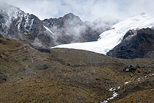
Huaytapallana (possibly from in the Quechua spelling Waytapallana; wayta wild flower, a little bunch of flowers, pallay to collect, pallana an instrument to collect fruit / collectable, Waytapallana "a place where you collect wild flowers",[1][2]) or Lasuntay is the highest peak in the Huaytapallana mountain range in the Andes of Peru.[3] Its summit reaches about 5,557 m (18,232 ft) above sea level. The mountain is situated in the Junín Region, Huancayo Province, in the districts of Huancayo and Pariahuanca.[4]
Legend
[edit]The legend says that the son of Lord Parya Qaqa, a very curious and defiant man became an eagle to see from above, in his flight he noticed a green place in the middle of the rocks. When he reached the place he saw a maiden in the Carhuacocha lagoon. The beautiful young woman was the daughter of Wallallu Qarwinchu, called Huaytapallana. The young people fell in love but their parents, the gods Parya Qaqa and Wallallu Qarwinchu, became enemies because of the love that arose between them, but both were punished by Wiraqucha and locked under the ice of the great snow-capped mountain.
Every year, several Andean priests go to the foot of the snowy Huaytapallana to perform their Andean rites of gratitude for one more year of life to the earth, these rites are better known as “The payments to the earth”.
Hydrology
[edit]The area is characterized by its six lagoons: Ancapuachanan, Carhuacocha, Chuspicocha, Cocha Grande or Jatunccocha, Lazo Huntay and Pumacocha. Three rivers originate from these lakes. The Shullcas River, which flows to the city of Huancayo, originates at the junction of the Chuspicocha and Lazo Huntay lagoons. It is also the most important source of drinking water for this urban agglomeration. The Yaracyacu, which flows to Pariahuanca, is formed in the Cocha Grande and Carhuacocha lagoons. And the Chiapuquio River, which flows down through Concepción, emerges from the Putcacocha lagoon.
Orography
[edit]Main article: Huaytapallana mountain range
Huaytapallana has an altitude at its highest peak of 5,557 meters. Its second peak, Yanahucsha, measures 5,530 meters. The total area of the zone is 378.40 km². There are also numerous other peaks in the mountain range, including the following:
- Huaytapallana (5,557 m asl)
- Yanahucsha (5,530 m asl)
- Chuspi (5,400 m asl)
- Anchigrande (5,350 m asl)
- Cochas (5. 315 m asl)
- Tello (5,300 m asl)
- Talves (5,285 m asl)
- Pacaco (5,250 m asl)
- Putcacocha (5,236 m asl).
Accessibility
[edit]The Huaytapallana mountain range is 2 hours by paved road from the city of Huancayo, in the department of Junin. Huancayo is five hours away from Lima by car (without much traffic), on the other hand by bus 7 hours on average. The starting point of the expeditions in the mountain range is called Virgen de las Nieves, located at 4,000 meters above sea level. From this point there are two itineraries after which you can start the ascent to the snowy Huaytapallana to the top of its highest peak. One of the itineraries reaches the refuge for climbers after a two-hour walk, passing by the Carhuaccocha, Cocha Grande and Yanahucsha lakes. Another, lasting three and a half hours, leads to the Lazo Huntay lagoon.
Culture
[edit]It is believed that the spirit of an Andean ancestor called “Wallallu Qarwinchu” dwells in this snow-capped mountain. The inhabitants of the area offer gifts to him and to the earth to avoid disasters that could occur.
Gallery
[edit]

References
[edit]- ^ Teofilo Laime Ajacopa, Diccionario Bilingüe Iskay simipi yuyayk'ancha, La Paz, 2007 (Quechua-Spanish dictionary)
- ^ Diccionario Quechua - Español - Quechua, Academía Mayor de la Lengua Quechua, Gobierno Regional Cusco, Cusco 2005 (Quechua_Spanish dictionary)
- ^ Evelio Echevarría, Cordillera Huaytapallana, Peru, in: The Alpine Journal, 2009, p. 161-167
- ^ escale.minedu.gob.pe - UGEL map of the Huancayo Province (Junín Region)
External links
[edit]- Un nevado que se marcha
- Apu Huaytapallana (broken link available on Internet Archive; see history, first version and latest).
- Videos de turismo en el Nevado Huaytapallana
- Página del nevado de Huaytapallana
- Expedición exploratoria de ascenso al Nevado Cochas (broken link available on Internet Archive; see history, first version and latest). - Crossing to Nevado Cochas by the Ruta Vertikal Group.

