Kaoh Nheaek District
Appearance
Kaoh Nheaek District
ស្រុកកោះញែក | |
|---|---|
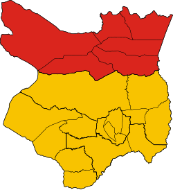
 District location in Mondulkiri Province | |
| Coordinates: 13°03′39″N 107°00′24″E / 13.0609°N 107.0067°E | |
| Country | |
| Province | Mondulkiri |
| Population (1998) | |
| • Total | 8,919[1] |
| Time zone | UTC+7 (ICT) |
| Geocode | 1102 |
Kaoh Nheaek (Khmer: កោះញែក, pronounced [kɑh ɲɛːk]) is a district (srok) in Mondulkiri Province, Cambodia.
References
[edit]- ^ "General Population Census of Cambodia 1998, Final Census Results" (PDF). National Institute of Statistics, Ministry of Planning, Cambodia. August 2002. Retrieved 2010-11-25. See page 164.
13°03′39″N 107°00′24″E / 13.0609°N 107.0067°E

