Atlantic Canada
Atlantic Canada
Provinces de l'Atlantique (French) | |
|---|---|
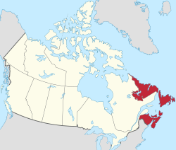
 Atlantic Canada (red) within the rest of Canada | |
| Country | Canada |
| Composition | |
| Most populous municipality | Halifax |
| Area | |
| • Total | 488,000 km2 (188,000 sq mi) |
| Population (2021) | |
| • Total | 2,409,874 |
| • Density | 4/km2 (10/sq mi) |
Atlantic Canada, also called the Atlantic provinces (French: provinces de l'Atlantique), is the region of Eastern Canada comprising the provinces located on the Atlantic coast, excluding Quebec. The four provinces are New Brunswick, Newfoundland and Labrador, Nova Scotia, and Prince Edward Island.[1] As of 2021, the landmass of the four Atlantic provinces was approximately 488,000 km2 (188,000 sq mi), and had a population of over 2.4 million people. The provinces combined had an approximate GDP of $121.888 billion in 2011.[2] The term Atlantic Canada was popularized following the admission of Newfoundland as a Canadian province in 1949.
History[edit]


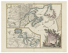
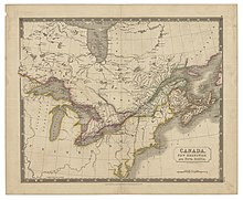
The Atlantic Provinces are the historical territories of the Mi'kmaq, Naskapi, Beothuk and Nunatsiavut peoples.[3][4][5][6] The people of Nunatsiavut are the Labrador inuit (Labradormiut), who are descended from the Thule people.[6] Acadia, a colony of New France, was established in areas of present day Atlantic Canada in 1604, under the leadership of Samuel de Champlain and Pierre Dugua, Sieur de Mons.[7] The French would form alliances with many indigenous groups within Atlantic Canada, including the Mi'kmaq of Acadia, who joined the Wabanaki Confederacy, important allies to New France.[8]
The first premier of Newfoundland, Joey Smallwood, coined the term "Atlantic Canada" when the Dominion of Newfoundland joined Canada in 1949.[9] He believed that it would have been presumptuous for Newfoundland to assume that it could include itself within the existing term "Maritime provinces," used to describe the cultural similarities shared by New Brunswick, Prince Edward Island, and Nova Scotia, which entered Confederation during the 19th century (New Brunswick and Nova Scotia were founding members of the Dominion of Canada in 1867, and Prince Edward Island joined in 1873).[10]
Geography[edit]
Although Quebec has a physical Atlantic coast on the Gulf of St. Lawrence, it is generally not considered an Atlantic Province; instead, it is classified as part of Central Canada, along with Ontario.[1]
Atlantic and Central Canada together are also known as Eastern Canada. Atlantic Canada includes a section of the Appalachian Mountains known as the Appalachian Uplands.[11] In each Atlantic province, Upland regions have been divided into three highland areas. The mountain range results in coastal regions being fjorded. Some areas contain glaciofluvial deposits.[12][13]
The following tables use Statistics Canada's 2021 census data.
Municipal geography[edit]
Provincial geography[edit]
| Province | Land area (km2) | References |
|---|---|---|
| New Brunswick | 71,248.50 | [62] |
| Newfoundland and Labrador | 358,170.37 | [63] |
| Nova Scotia | 52,824.71 | [64] |
| Prince Edward Island | 5,681.18 | [65] |
Demographics[edit]
The following tables provide 2021 census figures for "Metropolitan Areas" (built from entire municipalities) and "Population Centres" (limited to actual continuously-built-up areas) in Atlantic Canada. The list includes communities above 15,000, by Metropolitan Area population, or 10,000 by Population Centre population.
Municipal populations[edit]
| Municipality | Province | Type of Municipality | Population of Metropolitan Area (CA/CMA) | Population of Municipality | Population of Urban Area | References |
|---|---|---|---|---|---|---|
| Halifax | Nova Scotia | Municipality | 465,703 | 439,819 | 348,634 | [14] [15] [16] |
| St. John's | Newfoundland and Labrador | City | 212,579 | 110,525 | 185,565 | [17] [18] [19] |
| Moncton | New Brunswick | City | 157,717 | 79,470 | 119,785 | [20] [21] [22] |
| Saint John | New Brunswick | City | 130,613 | 69,895 | 63,447 | [23] [24] [25] |
| Fredericton | New Brunswick | City | 108,610 | 63,116 | 64,614 | [26] [27] [28] |
| Cape Breton | Nova Scotia | Municipality | 98,318 | 93,694 | 30,960 | [29] [30] [31] |
| Charlottetown | Prince Edward Island | City | 78,858 | 38,809 | 52,390 | [32] [33] [34] |
| Truro | Nova Scotia | Town | 46,157 | 12,954 | 23,583 | [35] [36] [37] |
| New Glasgow | Nova Scotia | Town | 34,397 | 9,471 | 19,316 | [38] [39] [40] |
| Bathurst | New Brunswick | City | 31,387 | 12,157 | 15,985 | [41] [42] [43] |
| Corner Brook | Newfoundland and Labrador | City | 29,762 | 19,333 | 19,129 | [44] [45] [46] |
| Miramichi | New Brunswick | City | 27,593 | 17,692 | 11,594 | [47] [48] [49] |
| Kentville | Nova Scotia | Town | 26,929 | 6,630 | 14,905 | [50] [51] [52] |
| Edmundston | New Brunswick | City | 22,144 | 16,437 | 13,125 | [53] [54] [55] |
| Summerside | Prince Edward Island | City | 18,157 | 16,001 | 14,952 | [56] [57] [58] |
| Grand Falls-Windsor | Newfoundland and Labrador | Town | 13,853 | 13,853 | 11,986 | [59] [60] [61] |
Provincial populations[edit]
| Province | Population | Population density (people per km2) | Reference |
|---|---|---|---|
| New Brunswick | 775,610 | 10 | [62] |
| Newfoundland and Labrador | 510,550 | 1 | [63] |
| Nova Scotia | 969,383 | 18 | [64] |
| Prince Edward Island | 154,331 | 27 | [65] |
Economy[edit]
Atlantic Canada's primary natural resource industries include fishing, hydroelectricity, forestry, and mining.[66] The Atlantic provinces contribute to around 75% of Canada's fish production, with many coastal communities primarily dependent on fisheries.[67] The access point for many of such fisheries being the Gulf of St. Lawrence and the Atlantic continental shelf.[68]
Nova Scotia produces 75% of Canada's gypsum. Salt and iron is also mined in the Atlantic provinces.[69][66]
See also[edit]
- Acadiensis, scholarly history journal covering Atlantic Canada
- Atlantic Provinces Chambers of Commerce
- Atlantic Northeast
References[edit]
- ^ Jump up to: a b Immigration, Refugees and Citizenship Canada (2009-09-01). "Discover Canada - Canada's Regions". www.canada.ca. Retrieved 2023-11-11.
- ^ "Gross domestic product, expenditure-based, by province and territory". Stats Canada. Nov 9, 2016. Retrieved Feb 7, 2017.
- ^ "Welcome". Native-Land.ca. Retrieved 2023-11-11.
- ^ "Mi'kmaq". www.thecanadianencyclopedia.ca. Retrieved 2023-11-11.
- ^ "Innu (Montagnais-Naskapi)". www.thecanadianencyclopedia.ca. Retrieved 2023-11-11.
- ^ Jump up to: a b "Nunatsiavut". www.thecanadianencyclopedia.ca. Retrieved 2023-11-11.
- ^ "History of Acadia". www.thecanadianencyclopedia.ca. Retrieved 2023-11-11.
- ^ "Wabanaki". 2011-07-19. Archived from the original on 2011-07-19. Retrieved 2023-11-12.
- ^ "Provincial Government: The Smallwood Years, 1949-1972". www.heritage.nf.ca. Retrieved 2023-11-11.
- ^ "Confederation | The Canadian Encyclopedia". www.thecanadianencyclopedia.ca. Retrieved 2023-11-11.
- ^ "Social Studies | Regions of Canada | Atlantic Region". gradefive.mrpolsky.com. Retrieved 2023-11-11.
- ^ Government of Canada, Natural Resources Canada (2016-09-12). "Natural Resources Canada. The Atlas of Canada. Physiographic Regions of Canada". atlas.gc.ca. Retrieved 2023-11-11.
- ^ "Geography of Newfoundland and Labrador". www.thecanadianencyclopedia.ca. Retrieved 2023-11-11.
- ^ Jump up to: a b "Census Profile, 2021 Census of Population". Statistics Canada. 9 February 2022. Retrieved 28 July 2022.
- ^ Jump up to: a b "Census Profile, 2021 Census of Population". Statistics Canada. 9 February 2022. Retrieved 28 July 2022.
- ^ Jump up to: a b "Census Profile, 2021 Census of Population". Statistics Canada. 9 February 2022. Retrieved 28 July 2022.
- ^ Jump up to: a b "Census Profile, 2021 Census of Population". Statistics Canada. Retrieved 28 July 2022.
- ^ Jump up to: a b "Census Profile, 2021 Census of Population". Statistics Canada. Retrieved 28 July 2022.
- ^ Jump up to: a b "Census Profile, 2021 Census of Population". Statistics Canada. Retrieved 28 July 2022.
- ^ Jump up to: a b "Census Profile, 2021 Census of Population". Statistics Canada. 9 February 2022. Retrieved 28 July 2022.
- ^ Jump up to: a b "Census Profile, 2021 Census of Population". Statistics Canada. 9 February 2022. Retrieved 28 July 2022.
- ^ Jump up to: a b "Census Profile, 2021 Census of Population". Statistics Canada. 9 February 2022. Retrieved 28 July 2022.
- ^ Jump up to: a b "Census Profile, 2021 Census of Population". Statistics Canada. Retrieved 28 July 2022.
- ^ Jump up to: a b "Census Profile, 2021 Census of Population". Statistics Canada. Retrieved 28 July 2022.
- ^ Jump up to: a b "Census Profile, 2021 Census of Population". Statistics Canada. Retrieved 28 July 2022.
- ^ Jump up to: a b "Census Profile, 2021 Census of Population". Statistics Canada. 9 February 2022. Retrieved 28 July 2022.
- ^ Jump up to: a b "Census Profile, 2021 Census of Population". Statistics Canada. 9 February 2022. Retrieved 28 July 2022.
- ^ Jump up to: a b "Census Profile, 2021 Census of Population". Statistics Canada. 9 February 2022. Retrieved 28 July 2022.
- ^ Jump up to: a b "Census Profile, 2021 Census of Population". Statistics Canada. Retrieved 28 July 2022.
- ^ Jump up to: a b "Census Profile, 2021 Census of Population". Statistics Canada. Retrieved 28 July 2022.
- ^ Jump up to: a b "Census Profile, 2021 Census of Population". Statistics Canada. Retrieved 28 July 2022.
- ^ Jump up to: a b "Census Profile, 2021 Census of Population". Statistics Canada. 9 February 2022. Retrieved 28 July 2022.
- ^ Jump up to: a b "Census Profile, 2021 Census of Population". Statistics Canada. 9 February 2022. Retrieved 28 July 2022.
- ^ Jump up to: a b "Census Profile, 2021 Census of Population". Statistics Canada. 9 February 2022. Retrieved 28 July 2022.
- ^ Jump up to: a b "Census Profile, 2021 Census of Population". Statistics Canada. 9 February 2022. Retrieved 28 July 2022.
- ^ Jump up to: a b "Census Profile, 2021 Census of Population". Statistics Canada. 9 February 2022. Retrieved 28 July 2022.
- ^ Jump up to: a b "Census Profile, 2021 Census of Population". Statistics Canada. 9 February 2022. Retrieved 28 July 2022.
- ^ Jump up to: a b "Census Profile, 2021 Census of Population". Statistics Canada. Retrieved 28 July 2022.
- ^ Jump up to: a b "Census Profile, 2021 Census of Population". Statistics Canada. Retrieved 28 July 2022.
- ^ Jump up to: a b "Census Profile, 2021 Census of Population". Statistics Canada. Retrieved 28 July 2022.
- ^ Jump up to: a b "Census Profile, 2021 Census of Population". Statistics Canada. 9 February 2022. Retrieved 28 July 2022.
- ^ Jump up to: a b "Census Profile, 2021 Census of Population". Statistics Canada. 9 February 2022. Retrieved 28 July 2022.
- ^ Jump up to: a b "Census Profile, 2021 Census of Population". Statistics Canada. 9 February 2022. Retrieved 28 July 2022.
- ^ Jump up to: a b "Census Profile, 2021 Census of Population". Statistics Canada. Retrieved 28 July 2022.
- ^ Jump up to: a b "Census Profile, 2021 Census of Population". Statistics Canada. Retrieved 28 July 2022.
- ^ Jump up to: a b "Census Profile, 2021 Census of Population". Statistics Canada. Retrieved 28 July 2022.
- ^ Jump up to: a b "Census Profile, 2021 Census of Population". Statistics Canada. 9 February 2022. Retrieved 28 July 2022.
- ^ Jump up to: a b "Census Profile, 2021 Census of Population". Statistics Canada. 9 February 2022. Retrieved 28 July 2022.
- ^ Jump up to: a b "Census Profile, 2021 Census of Population". Statistics Canada. 9 February 2022. Retrieved 28 July 2022.
- ^ Jump up to: a b "Census Profile, 2021 Census of Population". Statistics Canada. 9 February 2022. Retrieved 28 July 2022.
- ^ Jump up to: a b "Census Profile, 2021 Census of Population". Statistics Canada. 9 February 2022. Retrieved 28 July 2022.
- ^ Jump up to: a b "Census Profile, 2021 Census of Population". Statistics Canada. 9 February 2022. Retrieved 28 July 2022.
- ^ Jump up to: a b "Census Profile, 2021 Census of Population". Statistics Canada. 9 February 2022. Retrieved 28 July 2022.
- ^ Jump up to: a b "Census Profile, 2021 Census of Population". Statistics Canada. 9 February 2022. Retrieved 28 July 2022.
- ^ Jump up to: a b "Census Profile, 2021 Census of Population". Statistics Canada. 9 February 2022. Retrieved 28 July 2022.
- ^ Jump up to: a b "Census Profile, 2021 Census of Population". Statistics Canada. Retrieved 28 July 2022.
- ^ Jump up to: a b "Census Profile, 2021 Census of Population". Statistics Canada. Retrieved 28 July 2022.
- ^ Jump up to: a b "Census Profile, 2021 Census of Population". Statistics Canada. Retrieved 28 July 2022.
- ^ Jump up to: a b "Census Profile, 2021 Census of Population". Statistics Canada. Retrieved 27 July 2022.
- ^ Jump up to: a b "Census Profile, 2021 Census of Population". Statistics Canada. Retrieved 27 July 2022.
- ^ Jump up to: a b "Census Profile, 2021 Census of Population". Statistics Canada. Retrieved 27 July 2022.
- ^ Jump up to: a b "Census Profile, 2021 Census of Population". Statistics Canada. Retrieved 27 July 2022.
- ^ Jump up to: a b "Natural Resources in the Atlantic Provinces". www.thecanadianencyclopedia.ca. Retrieved 2023-11-11.
- ^ "Fisheries | The Canadian Encyclopedia". www.thecanadianencyclopedia.ca. Retrieved 2023-11-11.
- ^ "Natural Resources in the Atlantic Provinces". www.thecanadianencyclopedia.ca. Retrieved 2023-11-11.
- ^ "Gypsum | The Canadian Encyclopedia". thecanadianencyclopedia.ca. Retrieved 2023-11-11.
Further reading[edit]
- Hamilton, William Baillie (1996), Place names of Atlantic Canada, University of Toronto Press, ISBN 0-8020-0471-7
- MacEachern, Alan Andrew (2001), Natural selections: national parks in Atlantic Canada, McGill-Queen's University Press, ISBN 0-7735-2157-7
- Martinez, Andrew J; Martinez, Candace Storm (2003), Marine Life of the North Atlantic: Canada to New England, Aqua Quest Publications, ISBN 1-881652-32-7
- Prieur, Benoit (2005), Atlantic Canada, Ulysse Travel Publ, ISBN 2894647239


