From Wikipedia, the free encyclopedia
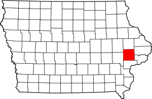
Location of Cedar County in Iowa This is a list of the National Register of Historic Places listings in Cedar County, Iowa .
This is intended to be a complete list of the properties and districts on the National Register of Historic Places in Cedar County , Iowa , United States . Latitude and longitude coordinates are provided for many National Register properties and districts; these locations may be seen together in a map.[ 1]
There are 18 properties and districts listed on the National Register in the county, including 1 National Historic Landmark .
This National Park Service list is complete through NPS recent listings posted August 16, 2024. [ 2]
[ 3] Name on the Register[ 4]
Image
Date listed[ 5]
Location
City or town
Description
1
Cedar County Sheriff's House and Jail Cedar County Sheriff's House and Jail September 13, 2003 (#03000913 ) 118 W. 4th St. 41°46′09″N 91°07′45″W / 41.769167°N 91.129167°W / 41.769167; -91.129167 (Cedar County Sheriff's House and Jail ) Tipton
2
Downey Savings Bank Downey Savings Bank July 12, 1976 (#76000740 ) Front St. 41°36′57″N 91°20′58″W / 41.615833°N 91.349444°W / 41.615833; -91.349444 (Downey Savings Bank ) Downey
3
Downey School Downey School May 28, 2019 (#100004017 ) 212 Broadway St. 41°36′54″N 91°20′57″W / 41.614997°N 91.349068°W / 41.614997; -91.349068 (Downey School ) Downey
4
Floral Hall Floral Hall November 7, 1976 (#76000741 ) West of Tipton at the Cedar County Fairgrounds 41°46′25″N 91°08′38″W / 41.773611°N 91.143889°W / 41.773611; -91.143889 (Floral Hall ) Tipton
5
William Green House William Green House April 29, 1999 (#99000488 ) 1709 Madison St. 41°40′26″N 91°09′43″W / 41.673889°N 91.161944°W / 41.673889; -91.161944 (William Green House ) Rochester
6
Gruwell and Crew General Store Gruwell and Crew General Store September 9, 1982 (#82002610 ) 109 W. Main St. 41°40′05″N 91°20′49″W / 41.668056°N 91.346944°W / 41.668056; -91.346944 (Gruwell and Crew General Store ) West Branch On the Most Endangered list of the Iowa Historic Preservation Alliance [ 6]
7
Hannah Morse Fowler Hall House Upload image May 1, 1998 (#98000378 ) 1285 Garfield Ave. 41°45′32″N 91°15′15″W / 41.758889°N 91.254167°W / 41.758889; -91.254167 (Hannah Morse Fowler Hall House ) Buchanan
8
Hardacre Theater Hardacre Theater January 5, 2016 (#15000951 ) 112 E. 5th St. 41°46′13″N 91°07′40″W / 41.770254°N 91.127852°W / 41.770254; -91.127852 (Hardacre Theater ) Tipton
9
Herbert Hoover National Historic Site Herbert Hoover National Historic Site October 15, 1966 (#66000110 ) Off Interstate 80 41°40′05″N 91°20′58″W / 41.668056°N 91.349444°W / 41.668056; -91.349444 (Herbert Hoover National Historic Site ) West Branch
10
Hotel Tipton Hotel Tipton November 5, 1998 (#98001328 ) 524-527 Cedar St. 41°46′15″N 91°07′43″W / 41.770833°N 91.128611°W / 41.770833; -91.128611 (Hotel Tipton ) Tipton
11
Kreinbring Phillips 66 Gas Station Kreinbring Phillips 66 Gas Station August 10, 2000 (#00000933 ) 200 Main St. 41°51′28″N 90°55′13″W / 41.857778°N 90.920278°W / 41.857778; -90.920278 (Kreinbring Phillips 66 Gas Station ) Lowden
12
Lincoln Hotel Lincoln Hotel June 28, 1996 (#96000699 ) 408 Main St. 41°51′28″N 90°55′35″W / 41.857778°N 90.926389°W / 41.857778; -90.926389 (Lincoln Hotel ) Lowden
13
Mill Creek Bridge Mill Creek Bridge June 25, 1998 (#98000743 ) Plum St. over Mill Creek 41°54′15″N 91°03′53″W / 41.904167°N 91.064722°W / 41.904167; -91.064722 (Mill Creek Bridge ) Clarence
14
Red Oak Grove Presbyterian Church and Cemetery Red Oak Grove Presbyterian Church and Cemetery February 3, 2010 (#09001302 ) 751 King Ave. 41°50′09″N 91°09′25″W / 41.835947°N 91.157072°W / 41.835947; -91.157072 (Red Oak Grove Presbyterian Church and Cemetery ) Tipton
15
John Christian and Bertha Landrock Reichert House John Christian and Bertha Landrock Reichert House December 19, 1991 (#91001861 ) 508 E. 4th St. 41°46′09″N 91°07′13″W / 41.769167°N 91.120278°W / 41.769167; -91.120278 (John Christian and Bertha Landrock Reichert House ) Tipton
16
St. Paul's Episcopal Church and Parish Hall St. Paul's Episcopal Church and Parish Hall January 3, 1985 (#85000002 ) 206 6th Ave. 41°35′55″N 90°54′46″W / 41.598611°N 90.912778°W / 41.598611; -90.912778 (St. Paul's Episcopal Church and Parish Hall ) Durant
17
Tipton State Bank Tipton State Bank September 14, 2000 (#00001075 ) 501 Cedar St. 41°46′13″N 91°07′42″W / 41.770278°N 91.128333°W / 41.770278; -91.128333 (Tipton State Bank ) Tipton
18
West Branch Commercial Historic District West Branch Commercial Historic District April 7, 1987 (#90000158 ) W. Main and N. Downey Sts.; also N. Downey and E. and W. Main Sts.; also 124 W. Main St. 41°40′23″N 91°20′54″W / 41.673056°N 91.348333°W / 41.673056; -91.348333 (West Branch Commercial Historic District ) West Branch Second and third sets of addresses represent boundary increases
^ The latitude and longitude information provided in this table was derived originally from the National Register Information System, which has been found to be fairly accurate for about 99% of listings. Some locations in this table may have been corrected to current GPS standards.
^ National Park Service, United States Department of the Interior , "National Register of Historic Places: Weekly List Actions" , retrieved August 16, 2024.
^ Numbers represent an alphabetical ordering by significant words. Various colorings, defined here , differentiate National Historic Landmarks and historic districts from other NRHP buildings, structures, sites or objects.
^ "National Register Information System" . National Register of Historic Places National Park Service . April 24, 2008.^ The eight-digit number below each date is the number assigned to each location in the National Register Information System database, which can be viewed by clicking the number.
^ Iowa's Most Endangered Properties, http://www.iowapreservation.org/endangered.php
Topics Lists by state Lists by insular areas Lists by associated state Other areas Related


