Mount Catherine
| Mount Catherine | |
|---|---|
| Gabal Katrîne | |
 | |
| Highest point | |
| Elevation | 2,629 m (8,625 ft)[a][2] |
| Prominence | 2,404 m (7,887 ft)[2] |
| Listing | Country high point Ultra |
| Coordinates | 28°30′42″N 33°57′09″E / 28.51167°N 33.95250°E[2] |
| Geography | |
| Location | Sinai Peninsula |
| Country | Egypt |
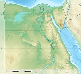
Mount Catherine (Arabic: جبل كاثرين; Greek: Όρος της Αγίας Αικατερίνης), locally known as Gabal Katrîne, is the highest mountain in Egypt. It is located near the town of Saint Catherine in the South Sinai Governorate.

The name is derived from the Christian tradition that angels transported to this mountain the body of the martyred Saint Catherine of Alexandria.
At the summit of the mountain, there is a chapel built in 1905[3] and a meteorological station.[4]
History
[edit]Archaeology
[edit]On the north of Mount Catherine, archaeologists uncovered a cave with paintings of people and animals in red pigment dates back to the Chalcolithic Period,c. 5th–4th millennium BC in January of 2020. According to John Darnell, red painted images are not as common as engraved images and text. The painting resembling a camel shows that at least some of the graffiti is not older than the first millennium BC and may belong to a later period. The cave was filled with graffiti from different periods over time.[5]
Geology
[edit]Mount Catherine is a large horst that rose in a vertical movement along the length of the Wadi Sabia fault in the Catherine Plateau during the Neogene period. The Catherine Plateau consists of different volcanic rocks that were formed at different times in the Precambrian era. These rocks include, among others: tuff, agglomerate, volcanic bombs and lava flows.[6] The volcanic rocks in this area have experienced significant cracking and weathering, leading to the formation of extensive screes, leading to increased water infiltration and subsequently impacting the local water regime.[6]

Climate
[edit]Precipitation is infrequent and sporadic with occasional snowfall occurring on the summit. During the winter season, at the mountain's uppermost reaches, typical conditions include an average maximum temperature of 5 degrees Celsius and an average minimum temperature of -3 degrees Celsius.
In summer, the average maximum temperature is 23 degrees Celsius and the average minimum temperature is 12 degrees Celsius. The average daily amplitude between temperatures is about 10 degrees Celsius.[6]
Vegetation
[edit]The snowfall on the mountain summits primarily infiltrates the screes, making it contribute minimally to the available water supply. Consequently, the mountain's vegetation is dominated by plants adapted to arid conditions. Within the mountainous region, various plant species thrive, including Artemisia herba-alba (mainly in the wadis), Zilla and Atraphaxis. Agathophora grows on the exposed, windswept slopes, while Tanacetum santolinoides is commonly found in proximity to rocky surfaces.[7] In Wadi Shaq Musa, which descends from the mountain, there is a concentration of Primula.[6]
Christian tradition
[edit]According to Christian tradition, Saint Catherine was tortured and killed in Alexandria by the Roman emperor Maxentius, at the beginning of the third century. She was executed because she refused to renounce her Christian faith.[8]
According to one legend angels placed her body on top of the mountain, where it was discovered by a monk.[9]
See also
[edit]- Saint Catherine's Monastery
- Mount Sinai
- List of Ultras of Africa
- List of elevation extremes by country
Notes
[edit]References
[edit]- ^ Maizlish, Aaron. "Arabian Peninsula and Middle East: Footnotes". peaklist.org. Retrieved 22 August 2021.
- ^ a b c Maizlish, Aaron. "Africa Ultra-Prominences"". Peaklist.org. Retrieved 30 September 2012.
- ^ "The Saint Catherine Area (Egypt) No 954". UNESCO. 30 July 2000.
- ^ "Mount Kātrīnā | mountain, Egypt | Britannica". www.britannica.com. Retrieved 18 October 2023.
- ^ McCall, Rosie (23 January 2020). "Cave Covered in Ancient Egyptian Paintings of Donkeys and People Discovered by Accident". Newsweek.
- ^ a b c d מדריך ישראל סיני וחבל עזה (in Hebrew). הוצאת כתר. 1979. pp. 254–251.
- ^ Moustafa, Abdel Raouf A.; Klopatek†, Jeffrey M. (1 August 1995). "Vegetation and landforms of the Saint Catherine area, southern Sinai, Egypt". Journal of Arid Environments. 30 (4): 385–395. doi:10.1006/jare.1995.0033. ISSN 0140-1963.
- ^ González Hernando, Irene (18 October 2018). "Abrir para comprender". Titivillus. 2: 27–55. doi:10.26754/ojs_titivillus/titivillus.201603127. ISSN 2603-9966.
- ^ "St. Catherine of Alexandria | Virgin, Martyr, Miracle Worker | Britannica". www.britannica.com. 21 September 2023. Retrieved 23 October 2023.
External links
[edit]

