Bundesautobahn 995
| A 995 | ||||
|---|---|---|---|---|
| Bundesautobahn 995 | ||||
 | ||||
 Motorway pond in Taufkirchen | ||||
| Route information | ||||
| Length | 11 km (6.8 mi) | |||
| Major junctions | ||||
| North end | ||||
| South end | ||||
| Location | ||||
| Country | Germany | |||
| States | Bavaria | |||
| Highway system | ||||
| ||||
| ||||
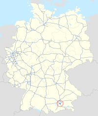
The Bundesautobahn 995 (translates from German as Federal Motorway 995, short form Autobahn 995, abbreviated as BAB 995 or A 995) (abbreviation: BAB 995 ) – short form: Autobahn 995 (abbreviation: A 995 ) is an autobahn near Munich in southern Germany. It connects the southwestern parts of Munich with the A 8 (Munich – Salzburg ) and A 99. It is around eleven kilometers long and has two lanes and hard a shoulder in each direction.
History
[edit]The entire section of road was completed in 1972 for the Olympic Games as the "Unterhaching – Taufkirchen bypass".[1][2]
Status
[edit]Despite the continuous blue signage and full motorway provisions, originally only the short stretch between the Munich-South junction and Sauerlach was actually dedicated as a federal motorway. The route between the Sauerlach junction and the southern border of Munich (at the Munich-Giesing junction) was designated as "Bundesstraße 13 (new)". The "Autobahndirektion Südbayern" was responsible for this section according to Section 3 (2) (a) of the Ordinance on the Transfer of Powers under the German Federal Trunk Roads Act. Therefore, no motorway or federal road number was given for the entire route, only the European route E54.
On January 1, 2018, the entire route was finally upgraded to Bundesautobahn 995 (BAB 995), which also required the installation of new signs showing the Autobahn number.[3]
As of October 1, 2019, the responsibilities for the A 995 are with the Hohenbrunn motorway maintenance department.[4]
Exit list
[edit]| State | District | Location | km | mi | Exit | Name | Destinations | Notes |
|---|---|---|---|---|---|---|---|---|
| Bayern | Munich | Munich | 0 | 0.0 | 1 | München-Giesing | northern endpoint of motorway | |
| Munich (district) | Unterhaching | 1.4 | 0.87 | 2 | Unterhaching-Nord | Unterhaching-Nord | ||
| 4.6 | 2.9 | 3 | Taufkirchen-West | Taufkirchen-West, Unterhaching-Süd | ||||
| Taufkirchen | 7.2 | 4.5 | 4 | Oberhaching | Oberhaching, Dietramszell, Grünwald, Taufkirchen-Süd | Dietramszell is only signed southbound | ||
| 7.5 | 4.7 | Parking area | Potzham-West | Potzham-West parking area | only southbound | |||
| 9.3 | 5.8 | 5 | Sauerlach | Sauerlach, Bad Tölz, Unterhaching | Bad Tölz only signed southbound, Unterhaching only signed northbound | |||
| Brunnthal | 10.5 | 6.5 | 6 | Kreuz München-Süd | southern endpoint of motorway | |||
1.000 mi = 1.609 km; 1.000 km = 0.621 mi
| ||||||||
References
[edit]- ^ Gemeinde Oberhaching, ed. (1999), "Albert Wachten: Der Verkehr in und um Oberhaching", Lebendige Heimat – Oberhaching (in German), p. 131, ISBN 3-921635-50-0
- ^ Bundestag-Drucksache 7/782 – Straßenbaubericht für das Jahr 1972 (PDF) (in German), 1973-06-13, p. 12
- ^ Lärmaktionsplan für das Umfeld der Bundesautobahnen in der Landeshauptstadt München, S. 58
- ^ Oberste Baubehörde im Bayerischen Staatsministerium des Innern, für Bau und Verkehr: Freistaat Bayern - Straßenübersichtskarte - Zuständigkeiten der Autobahnmeistereien. Archived 2016-09-17 at the Wayback Machine (PDF; 2,9 MB) .baysis.bayern.de, 1 January 2016; retrieved 17 September 2016.
External links
[edit]- Bundesautobahn 995 – detailed route plan (in German)


