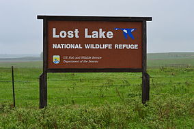
Lost Lake National Wildlife Refuge
Appearance
| Lost Lake National Wildlife Refuge | |
|---|---|
IUCN category IV (habitat/species management area) | |
 | |
| Location | McLean County, North Dakota, USA |
| Nearest city | Washburn, ND |
| Coordinates | 47°15′04″N 100°53′20″W / 47.25111°N 100.88889°W[1] |
| Area | 960 acres (390 ha) |
| Governing body | U.S. Fish and Wildlife Service |
Lost Lake National Wildlife Refuge is a 960-acre (390 ha) National Wildlife Refuge (NWR) in the U.S. state of North Dakota.[2][3] Lost Lake NWR is an easement refuge and is on privately owned land, but the landowners and U.S. Government work cooperatively to protect the resources.[4] The U.S. Fish and Wildlife Service oversees Lost Lake NWR from offices at Audubon National Wildlife Refuge.[5]
References
[edit]- ^ "Lost Lake National Wildlife Refuge". Geographic Names Information System. United States Geological Survey, United States Department of the Interior. Retrieved February 10, 2014.
- ^ "Annual Report of Lands Under Control of the U.S. Fish and Wildlife Service" (pdf). U.S. Fish and Wildlife Service. September 30, 2010. p. 25. Retrieved February 10, 2014.
- ^ Turtle Creek SW, ND (Map). Topoquest (USGS Quads). Retrieved February 10, 2014.
- ^ "Examples of Conservation Easements". U.S. Fish and Wildlife Service. Retrieved February 10, 2014.
- ^ "North Dakota National Wildlife Refuges". U.S. Fish and Wildlife Service. Retrieved February 10, 2014.
External links
[edit] Media related to Lost Lake National Wildlife Refuge at Wikimedia Commons
- Audubon National Wildlife Refuge: About the Complex
- Oh Ranger: Lost Lake National Wildlife Refuge

