Point Bonita Lighthouse
 Point Bonita Lighthouse in 2018 | |
 | |
| Location | San Francisco Bay California United States |
|---|---|
| Coordinates | 37°48′56″N 122°31′46″W / 37.815614°N 122.529578°W |
| Tower | |
| Constructed | 1855 (first) |
| Foundation | masonry basement |
| Construction | brick and cement building |
| Automated | 1980 |
| Height | 33 ft (10 m) |
| Shape | hexagonal tower with balcony and lantern on fog signal building |
| Markings | white tower, black lantern dome |
| Operator | Golden Gate National Recreation Area[1] [2] |
| Heritage | National Register of Historic Places listed place |
| Fog signal | 2 blasts every 30s |
| Light | |
| First lit | 1877 (current) |
| Focal height | 124 ft (38 m) |
| Lens | Second order Fresnel lens |
| Range | 18 nautical miles (33 km; 21 mi) |
| Characteristic | Oc W 4s. |
Point Bonita Light Station | |
| Area | 14 acres (5.7 ha) |
| Built | 1855 |
| Architectural style | Lighthouse |
| MPS | Light Stations of California MPS |
| NRHP reference No. | 91001099[3] |
| Added to NRHP | September 3, 1991 |
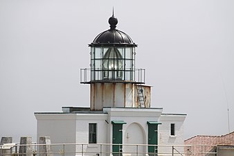
Point Bonita Lighthouse is a lighthouse located at Point Bonita at the San Francisco Bay entrance in the Marin Headlands near Sausalito, California. Point Bonita was the last staffed lighthouse on the California coast. It was added to the National Register of Historic Places in 1991.[3]
History
[edit]More than 300 boats ran aground near the Golden Gate during the California Gold Rush years, requiring a lighthouse.
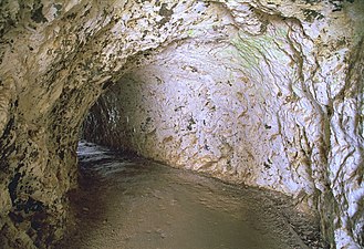
The original Point Bonita Lighthouse, a 56-foot (17 m) brick tower, was built in 1855 at 306 feet (93 m) above sea level with a second order Fresnel lens. This was too high. Unlike the East Coast of the United States, the West Coast has dense high fog, which leaves lower elevations clear. Since the original light was so high, it was often cloaked in fog and could not be seen from the sea. As a result, the lighthouse was moved to its current location at 124 feet (38 m) above sea level in 1877. To access the new site, a 118-foot (36 m) long tunnel was hand carved through hard rock.[4]
The lighthouse had the first fog signal on the West Coast, in the form of a 24-pounder siege gun.
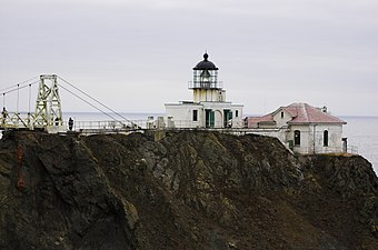
Up until 1940 the lighthouse could be reached by a trail, but erosion caused the trail to crumble into the sea. A wooden walkway was installed, but when that became treacherous a suspension bridge was built in 1954. This is the only lighthouse in the United States which can only be reached by a suspension bridge.
The suspension bridge underwent repairs in 1979 and again in 1991, but the metal components were not able to stand up to the sea spray. As a result, the suspension bridge to the light house was closed to public access on January 6, 2010. According to the Federal Highway Administration, the bridge, which was 56 years old, had started to rust. It was replaced by a new span which opened April 13, 2012.
The new bridge construction cost a little over $1 million. It is made of tropical hardwood with steel suspension cables and attachments.[5]
The United States Coast Guard currently maintains the light and fog signal.
Public access
[edit]The lighthouse is accessible to the public during limited hours (12:30–3:30 p.m.) on Sundays and Mondays,[6] as well as on ranger-led interpretive sunset hikes, which requires a sign-up. Access to the bridge is barred at other times by a metal door on the shore end of the tunnel.
The lighthouse closed in March 2020 for the COVID-19 pandemic, but resumed tours two years later on February 20, 2022.[7]
Gallery
[edit]In popular media
[edit]On the television show Murder in the First the lighthouse was a setting at the end of the second-season episode "Schizofrenzy".
The lighthouse can be found in the video game Watch Dogs 2.
See also
[edit]- List of bridges documented by the Historic American Engineering Record in California
- List of lighthouses in the United States
References
[edit]- ^ Rowlett, Russ. "Lighthouses of the United States: Northern California". The Lighthouse Directory. University of North Carolina at Chapel Hill. Retrieved 2016-06-13.
- ^ California Historic Light Station Information & Photography United States Coast Guard. Retrieved 13 June 2016
- ^ a b "National Register Information System". National Register of Historic Places. National Park Service. November 2, 2013.
- ^ "Historic Light Station Information and Photography: California". United States Coast Guard Historian's Office. Archived from the original on 2017-05-01. Retrieved 2008-08-19.
- ^ "Point Bonita Lighthouse bridge closed; new span needed - Marin Independent Journal". Archived from the original on 2011-01-08. Retrieved 2011-01-07.
- ^ "Point Bonita Lighthouse - Golden Gate National Recreation Area (U.S. National Park Service)".
- ^ "Point Bonita Lighthouse Reopens to Public After Pandemic Closure". CBS News.
External links
[edit]- Lighthousefriends.com entry (photos and history)
- NPA Website about the light house
- Historic American Engineering Record (HAER) No. CA-2289, "Point Bonita Lighthouse Suspension Bridge, Sausalito, Marin County, CA", 23 photos, 12 data pages, 3 photo caption pages
- Lighthouses in the San Francisco Bay Area
- Transportation buildings and structures in Marin County, California
- Golden Gate National Recreation Area
- Historic American Engineering Record in California
- Lighthouses completed in 1855
- Lighthouses on the National Register of Historic Places in California
- National Register of Historic Places in Marin County, California
- Sausalito, California
- Tourist attractions in Marin County, California
- 1855 establishments in California


