Timaru District
Timaru District | |
|---|---|
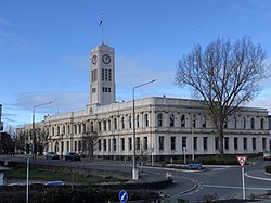
 Timaru District Council building | |
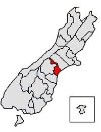
 Location of the Timaru District within the South Island | |
| Country | New Zealand |
| Island | South Island |
| Region | Canterbury |
| Communities |
|
| Wards |
|
| Formed | 1989 |
| Seat | Timaru |
| Government | |
| • Mayor | Nigel Bowen |
| • Deputy Mayor | Steve Wills |
| • Territorial authority | Timaru District Council |
| Area | |
| • Total | 2,732.41 km2 (1,054.99 sq mi) |
| Population (June 2023)[2] | |
| • Total | 48,900 |
| • Density | 18/km2 (46/sq mi) |
| Time zone | UTC+12 (NZST) |
| • Summer (DST) | UTC+13 (NZDT) |
| Postcode(s) | |
| Website | www |
Timaru District is a local government district on New Zealand's South Island, administered by the Timaru District Council. It is part of the larger Canterbury Region. Timaru district was formed in 1989 from the amalgamation of Timaru City, Geraldine district, Temuka district and Stratham district.
Geography
[edit]The Timaru District is located on the east coast of the South Island and stretches inland as far as the Main Divide. The district has a population of 48,900 (June 2023).[2] Timaru is the main town. The next biggest towns in order are Temuka, Geraldine and Pleasant Point. Smaller settlements include Arundel, Cave, Orari and Winchester. The Timaru District Library has branches situated in Timaru, Temuka and Geraldine.
Demographics
[edit]Timaru District covers 2,732.41 km2 (1,054.99 sq mi)[1] and had an estimated population of 48,900 as of June 2023,[2] with a population density of 17.9 people per km2.
| Year | Pop. | ±% p.a. |
|---|---|---|
| 2006 | 42,870 | — |
| 2013 | 43,932 | +0.35% |
| 2018 | 46,296 | +1.05% |
| 2023 | 47,547 | +0.53% |
| Source: [3][4] | ||
| Ethnicity | Population |
|---|---|
| New Zealand European | |
| Māori | |
| Pasifika | |
| Asian | |
| MELAA | |
| Other |
Timaru District had a population of 47,547 in the 2023 New Zealand census, an increase of 1,251 people (2.7%) since the 2018 census, and an increase of 3,615 people (8.2%) since the 2013 census. There were 21,579 dwellings. The median age was 44.6 years (compared with 38.1 years nationally). There were 8,349 people (17.6%) aged under 15 years, 7,452 (15.7%) aged 15 to 29, 20,850 (43.9%) aged 30 to 64, and 10,902 (22.9%) aged 65 or older.[4]
Ethnicities were 87.3% European/Pākehā, 10.4% Māori, 3.5% Pasifika, 5.8% Asian, 0.9% Middle Eastern, Latin American and African New Zealanders, and 1.5% other. People may identify with more than one ethnicity.[4]
Timaru District had a population of 46,296 at the 2018 New Zealand census. There were 19,119 households, comprising 22,812 males and 23,481 females, giving a sex ratio of 0.97 males per female.
The percentage of people born overseas was 13.4, compared with 27.1% nationally.
Although some people chose not to answer the census's question about religious affiliation, 48.4% had no religion, 40.8% were Christian, 0.3% had Māori religious beliefs, 0.7% were Hindu, 0.2% were Muslim, 0.3% were Buddhist and 1.5% had other religions.
Of those at least 15 years old, 4,887 (12.9%) people had a bachelor's or higher degree, and 9,597 (25.3%) people had no formal qualifications. The median income was $30,300, compared with $31,800 nationally. 5,415 people (14.2%) earned over $70,000 compared to 17.2% nationally. The employment status of those at least 15 was that 18,456 (48.6%) people were employed full-time, 5,751 (15.1%) were part-time, and 951 (2.5%) were unemployed.[3]
| Name | Area (km2) | Population | Density (per km2) | Households | Median age | Median income |
|---|---|---|---|---|---|---|
| Geraldine Ward | 1,643.63 | 5,835 | 3.55 | 2,436 | 47.8 years | $31,000 |
| Pleasant Point-Temuka Ward | 832.16 | 9,336 | 11.22 | 3,819 | 44.5 years | $31,200 |
| Timaru Ward | 256.62 | 31,122 | 121.28 | 12,864 | 44.2 years | $29,900 |
| New Zealand | 37.4 years | $31,800 |
History
[edit]Timaru has its origins in a sheep station, The Levels, run by George Rhodes.[5][6] In 1868, residents petitioned for the town to be established as a borough, and the Timaru Borough Council was proclaimed in 1868.[7]
Economy
[edit]
Venture Timaru is the regional development and tourism organisation.[citation needed]
References
[edit]- ^ a b "ArcGIS Web Application". statsnz.maps.arcgis.com. Retrieved 13 March 2022.
- ^ a b c "Subnational population estimates (RC, SA2), by age and sex, at 30 June 1996-2023 (2023 boundaries)". Statistics New Zealand. Retrieved 25 October 2023. (regional councils); "Subnational population estimates (TA, SA2), by age and sex, at 30 June 1996-2023 (2023 boundaries)". Statistics New Zealand. Retrieved 25 October 2023. (territorial authorities); "Subnational population estimates (urban rural), by age and sex, at 30 June 1996-2023 (2023 boundaries)". Statistics New Zealand. Retrieved 25 October 2023. (urban areas)
- ^ a b "Statistical area 1 dataset for 2018 Census". Statistics New Zealand. March 2020. Timaru District (064). 2018 Census place summary: Timaru District
- ^ a b c "2023 Census national and subnational usually resident population counts and dwelling counts" (Microsoft Excel). Stats NZ - Tatauranga Aotearoa. Retrieved 29 May 2024.
- ^ Pinney, Robert. "George Rhodes". Dictionary of New Zealand Biography. Ministry for Culture and Heritage. Retrieved 10 December 2011.
- ^ Cyclopedia Company Limited (1903). "Timaru". The Cyclopedia of New Zealand : Canterbury Provincial District. Christchurch: The Cyclopedia of New Zealand. Retrieved 22 August 2015.
- ^ Cyclopedia Company Limited (1903). "Timaru Corporation". The Cyclopedia of New Zealand : Canterbury Provincial District. Christchurch: The Cyclopedia of New Zealand. Retrieved 22 August 2015.

