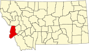
Grantsdale, Montana
Appearance
Grantsdale, Montana | |
|---|---|
| Coordinates: 46°12′13″N 114°08′30″W / 46.20361°N 114.14167°W | |
| Country | United States |
| State | Montana |
| County | Ravalli |
| Elevation | 3,675 ft (1,120 m) |
| Time zone | UTC-7 (Mountain (MST)) |
| • Summer (DST) | UTC-6 (MDT) |
| ZIP code | 59835 |
| Area code | 406 |
| GNIS feature ID | 784190[1] |
Grantsdale is an unincorporated community in Ravalli County, Montana, United States. Grantsdale is located near U.S. Route 93 and Montana Highway 38, 3 miles (4.8 km) south of Hamilton. The community had a post office until October 29, 1988; it retains its own ZIP code, 59835.[2][3]
Initially called Skalkaho Creek, the town became Grantsdale in about 1888 after H. H. Grant, the town's founder.[4]
References
[edit]- ^ a b U.S. Geological Survey Geographic Names Information System: Grantsdale, Montana
- ^ United States Postal Service (2012). "USPS - Look Up a ZIP Code". Retrieved February 15, 2012.
- ^ "Postmaster Finder - Post Offices by ZIP Code". United States Postal Service. Archived from the original on October 17, 2020. Retrieved July 9, 2014.
- ^ "Grantsdale". Montana Place Names Companion. Montana Historical Society. Retrieved April 3, 2021.


