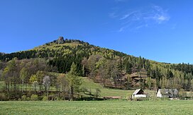
Rudawy Janowickie
Appearance
| Rudawy Janowickie | |
|---|---|
 | |
| Highest point | |
| Peak | Ostra Mała |
| Listing | Sudetes |
| Coordinates | 50°48′N 15°54′E / 50.800°N 15.900°E |
| Geography | |
| Country | Poland |
| State | Lower Silesian Voivodeship |
The Rudawy Janowickie (Czech: Janovické rudohoří) or Landeshut Ridge is a mountain range in the Sudetes in south-western Poland.
History
[edit]During World War II, Nazi Germany established and operated two subcamps of the Gross-Rosen concentration camp in the Rudawy Janowickie.[1]
Poland's first Hindu temple, the New Shantipur Temple in Czarnów, was founded in the Rudawy Janowickie in 1980.
References
[edit]- ^ "Subcamps of KL Gross-Rosen". Gross-Rosen Museum in Rogoźnica. Retrieved 6 November 2023.
Wikimedia Commons has media related to Rudawy Janowickie.
See also
[edit]
