Dongtou, Wenzhou
You can help expand this article with text translated from the corresponding article in Chinese. (April 2015) Click [show] for important translation instructions.
|
This article needs additional citations for verification. (June 2018) |
Dongtou
洞头区 Tungtou | |
|---|---|
 Dongtou | |
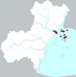
 Location in Wenzhou | |
| Coordinates: 27°50′10″N 121°09′25″E / 27.836°N 121.157°E | |
| Country | People's Republic of China |
| Province | Zhejiang |
| Prefecture-level city | Wenzhou |
| Area | |
| • Total | 2,700.3 km2 (1,042.6 sq mi) |
| • Land | 100.3 km2 (38.7 sq mi) |
| • Water | 2,600 km2 (1,000 sq mi) |
| Population (2012)[1] | |
| • Total | 130,600 |
| • Density | 1,302.1/km2 (3,372/sq mi) |
| Time zone | UTC+8 (China Standard) |
| Website | www |
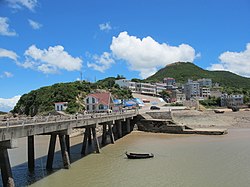
District (simplified Chinese: 洞头区; traditional Chinese: 洞頭區; pinyin: Dòngtóu Qū) is a district consisting of 168[1] islands in the East China Sea, and is under the jurisdiction of prefecture-level city of Wenzhou, in southern Zhejiang province, China. It has a total area of 2,700.3 km2 (1,042.6 sq mi), of which 100.3 km2 (38.7 sq mi) is land, and, as of 2012[update], had a population of 130,600.[1] It was known as Dongtou County (洞头县) until 2 September 2015, when, with the approval of the State Council, it was converted to a district.
Transport
[edit]It is served by 4 stations on Line S1 (Wenzhou Metro): Lingkun, Oujiangkou, Ouhua and Shuang'ou Avenue.[2]
Administrative divisions
[edit]Subdistricts:[3]
- Bei'ao Subdistrict (北岙街道), Yuanjue Subdistrict (元觉街道), Dongping Subdistrict (东屏街道), Niyu Subdistrict (霓屿街道)
The only town is Damen (大门镇), and the only township is Luxi Township (鹿西乡)
Climate
[edit]| Climate data for Dongtou (1991–2020 normals) | |||||||||||||
|---|---|---|---|---|---|---|---|---|---|---|---|---|---|
| Month | Jan | Feb | Mar | Apr | May | Jun | Jul | Aug | Sep | Oct | Nov | Dec | Year |
| Mean daily maximum °C (°F) | 10.9 (51.6) |
11.5 (52.7) |
14.3 (57.7) |
18.8 (65.8) |
23.3 (73.9) |
26.4 (79.5) |
29.7 (85.5) |
30.4 (86.7) |
28.2 (82.8) |
23.9 (75.0) |
19.1 (66.4) |
13.8 (56.8) |
20.9 (69.5) |
| Daily mean °C (°F) | 8.3 (46.9) |
8.7 (47.7) |
11.3 (52.3) |
15.7 (60.3) |
20.5 (68.9) |
24.0 (75.2) |
27.3 (81.1) |
27.9 (82.2) |
25.6 (78.1) |
21.3 (70.3) |
16.6 (61.9) |
11.1 (52.0) |
18.2 (64.7) |
| Mean daily minimum °C (°F) | 6.3 (43.3) |
6.7 (44.1) |
9.2 (48.6) |
13.5 (56.3) |
18.4 (65.1) |
22.3 (72.1) |
25.5 (77.9) |
26.0 (78.8) |
23.7 (74.7) |
19.3 (66.7) |
14.6 (58.3) |
9.0 (48.2) |
16.2 (61.2) |
| Average precipitation mm (inches) | 64.3 (2.53) |
80.7 (3.18) |
133.5 (5.26) |
130.5 (5.14) |
154.5 (6.08) |
196.5 (7.74) |
110.1 (4.33) |
192.3 (7.57) |
141.2 (5.56) |
65.8 (2.59) |
74.4 (2.93) |
58.8 (2.31) |
1,402.6 (55.22) |
| Average precipitation days (≥ 0.1 mm) | 11.8 | 12.9 | 17.7 | 16.1 | 14.9 | 15.6 | 9.4 | 11.4 | 11.1 | 6.6 | 10.1 | 9.9 | 147.5 |
| Average snowy days | 1.2 | 1.3 | 0.4 | 0 | 0 | 0 | 0 | 0 | 0 | 0 | 0 | 0.4 | 3.3 |
| Average relative humidity (%) | 73 | 77 | 81 | 83 | 85 | 89 | 87 | 84 | 78 | 73 | 74 | 71 | 80 |
| Mean monthly sunshine hours | 108.9 | 98.1 | 111.7 | 127.4 | 136.8 | 134.1 | 242.9 | 238.9 | 194.3 | 189.8 | 134.9 | 131.2 | 1,849 |
| Percent possible sunshine | 33 | 31 | 30 | 33 | 33 | 32 | 58 | 59 | 53 | 54 | 42 | 41 | 42 |
| Source: China Meteorological Administration[4][5] | |||||||||||||
Economy
[edit]Dongtou possesses the second-largest fishery in Zhejiang, reaching an area of about 4,800 km2 (1,900 sq mi),[1] and is known as the "Hijiki capital of China" (中国羊栖菜之乡) as well as the "Seaweed capital of Zhejiang" (浙江紫菜之乡).[1]
References
[edit]- ^ a b c d e f 走进洞头. Dongtou People's Government (in Simplified Chinese). Retrieved 14 June 2018.
- ^ "Dongtou district". www.ezhejiang.gov.cn. Retrieved 2023-04-05.
- ^ "温州市-行政区划网 www.xzqh.org" (in Chinese). XZQH. Retrieved 2012-05-24.
- ^ 中国气象数据网 – WeatherBk Data (in Simplified Chinese). China Meteorological Administration. Retrieved 22 September 2023.
- ^ 中国气象数据网 (in Simplified Chinese). China Meteorological Administration. Retrieved 22 September 2023.

