
1887 Atlantic hurricane season
| 1887 Atlantic hurricane season | |
|---|---|
 Season summary map | |
| Seasonal boundaries | |
| First system formed | May 15, 1887 |
| Last system dissipated | December 12, 1887 |
| Strongest storm | |
| Name | Seven |
| • Maximum winds | 125 mph (205 km/h) (1-minute sustained) |
| • Lowest pressure | 946 mbar (hPa; 27.94 inHg) |
| Seasonal statistics | |
| Total depressions | 19 |
| Total storms | 19 |
| Hurricanes | 11 |
| Major hurricanes (Cat. 3+) | 2 |
| Total fatalities | 2+ total |
| Total damage | Unknown |
The 1887 Atlantic hurricane season was the most active Atlantic hurricane season on record at the time in terms of the number of known tropical storms that had formed, with 19. This total has since been equaled or surpassed multiple times.[1] The 1887 season featured five off-season storms, with tropical activity occurring as early as May, and as late as December. It is also worthy of note that the volume of recorded activity was documented largely without the benefit of modern technology.[2] Tropical cyclones during this era did not approach populated areas or shipping lanes, especially if they were relatively weak and of short duration, may have remained undetected. Because technologies such as satellite monitoring were not available until the 1960s, historical data on tropical cyclones from this period may not be comprehensive. An undercount bias of zero to six tropical cyclones per year between 1851 and 1885 and zero to four per year between 1886 and 1910 has been estimated.[3] Of the known 1887 cyclones, Tropical Storm One and Tropical Storm Three were first documented in 1996 by Jose Fernandez-Partagas and Henry Diaz. They also proposed large alterations to the known tracks of several of the other 1887 storms.[4] Later re-analysis led to the known duration of Hurricane Six, and also that of Hurricane Fifteen, being increased.[5]
Eleven of the season's nineteen known storms attained hurricane status. However, only two of these storms became major hurricanes, with sustained winds of over 111 mph (179 km/h); the strongest reached peak winds of 125 mph (205 km/h), with a minimum barometric pressure of 946 mbar (27.9 inHg) off the East Coast of the United States in late August. Only a few of the storms during the 1887 season did not impact land, but there was a low number of deaths.
Timeline
[edit]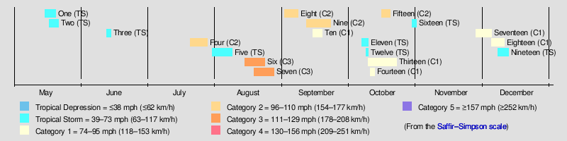
Systems
[edit]Tropical Storm One
[edit]| Tropical storm (SSHWS) | |
 | |
| Duration | May 15 – May 18 |
|---|---|
| Peak intensity | 70 mph (110 km/h) (1-min); ≤997 mbar (hPa) |
On May 15, the steamship Orinoco, docked on Bermuda, reported gale-force winds and very heavy rainfall.[6] Consequently, the track for this storm begins to the south-southeast of the fon that day.[1] The Orinoco also recorded a barometric pressure of 997 mbar (29.4 inHg) on May 16,[6] the day the storm made its closest approach to Bermuda, leading the Atlantic hurricane reanalysis project to estimate that the cyclone peaked with winds of 70 mph (110 km/h).[5] Initially, the system moved northwestward, until turning to the north by May 17. It is likely that the storm became extratropical on the following day. The remnants then turned northeastward over Atlantic Canada, crossing Nova Scotia and Newfoundland before dissipating on May 20.[1] A reanalysis study authored by climate researcher Michael Chenoweth and published in 2014 considers this storm to have been a subtropical cyclone.[7]
Tropical Storm Two
[edit]| Tropical storm (SSHWS) | |
 | |
| Duration | May 17 – May 21 |
|---|---|
| Peak intensity | 60 mph (95 km/h) (1-min); ≤1002 mbar (hPa) |
Based on data from the steamships Alvena, Athos, and Ponoma,[6] another May storm formed south of Jamaica on May 17 and initially moved generally northwestward. After passing just west of Jamaica on the following day, the cyclone then turned northeast.[1] The Alvena recorded a barometric pressure of 1,002 mbar (29.6 inHg) late on May 18,[6] causing the Atlantic hurricane reanalysis project to estimate that the storm peaked with winds of 60 mph (95 km/h).[5] Early the next day, the cyclone made landfall in Cuba near Santa Cruz del Sur, several hours before emerging into the Atlantic. Throughout May 20, the storm crossed through the central Bahamas, passing near or over Exuma, Long Island, and Cat Island. The cyclone was last noted about halfway between Bermuda and the Bahamas on May 21.[1] Impact in Cuba as a result of this storm was mainly limited to some heavy rainfall and squally conditions.[6]
Chenoweth proposed moving the path of the storm slightly farther west over Cuba and the Bahamas.[7]
Tropical Storm Three
[edit]| Tropical storm (SSHWS) | |
 | |
| Duration | June 11 – June 14 |
|---|---|
| Peak intensity | 40 mph (65 km/h) (1-min); |
Weather conditions in Cuba beginning on June 11 suggest that a tropical depression over the northwestward Caribbean on June 11.[6][1] The depression passed just west of Cabo San Antonio early the following day while entering the Gulf of Mexico, where it quickly intensified into a tropical storm. However, it is estimated that the cyclone did not strengthen beyond winds of 40 mph (65 km/h) prior to making landfall near Pascagoula, Mississippi, early on June 14. The storm then dissipated later that day.[1] Chenoweth extends the duration of this cyclone back to June 10, with it attaining tropical storm status by the next day. The study by Chenoweth also concludes that this storm did not make landfall and instead meandered around the central Gulf of Mexico until dissipating on June 15.[7]
At the time, the storm was the earliest-forming third nameable storm in the Atlantic on record; this record has since been surpassed by 2016's Tropical Storm Colin and later by 2020's Tropical Storm Cristobal. Heavy rains fell over western Cuba, leading to flooding. Meteorologist Simón Sarasola reported in 1928 that this flooding caused crop damage and a loss of "some lives". Offshore Pensacola, Florida, the steamship Vidette began taking on water, necessitating that the crew be rescued by a tugboat.[6]
Hurricane Four
[edit]| Category 2 hurricane (SSHWS) | |
  | |
| Duration | July 20 – July 28 |
|---|---|
| Peak intensity | 100 mph (155 km/h) (1-min); 978 mbar (hPa) |
The bark Florence, stationed at Barbados on July 20, recorded squally weather and decreasing barometric pressures.[4] Consequently, the track for this system begins on that day about 150 mi (240 km) southeast of the island. Later on July 20, the cyclone entered the Caribbean after passing through Saint Vincent and the Grenadines. Intensifying into a hurricane early the next day, the storm reached Category 2 status on the modern-day Saffir–Simpson scale on July 22. After moving west-northwestward for its duration thus far, the hurricane turned northwestward over the northwestern Caribbean on July 25. The cyclone struck the northeastern Yucatán Peninsula later that day and curved northward. Weakening to a Category 1 hurricane over the Gulf of Mexico, the storm turned north-northeastward. Around 15:00 UTC on July 27, the hurricane made landfall near Fort Walton Beach, Florida, with winds of 85 mph (140 km/h), with an estimated barometric pressure of 978 mbar (28.9 inHg). The storm continued north-northeastward as a tropical storm, before dissipating late on July 28 near Atlanta, Georgia.[1]
On Barbados, the storm caused several vessels to be wrecked or to be run aground. Although the hurricane passed far to the south of Cuba, it caused several vessels to sink at Batabanó and brought heavy rain and flooding to the islands interior.[4] In Florida, rainfall reached 8 in (200 mm) at Cedar Key.[8] Strong winds downed hundreds of trees and destroyed a college building, a mill, and several small homes in DeFuniak Springs. Damage in the town was estimated at $5,000. In Caryville, the storm partially destroyed a mill and demolished a church. Additionally, Holmes and Walton counties reported heavy agricultural damage.[9] Heavy rains fell in some other areas of the Southeastern United States, including a peak total of 16.5 in (420 mm) of precipitation at Union Point, Georgia.[10] According to The Atlanta Constitution, the Chattahoochee River overflowed its banks from Columbus, Georgia, to Apalachicola, Florida, submerging an average of 5 mi (8.0 km) of land along the waterway. [11] Consequently, extensive losses to cotton crops occurred, especially in Georgia and Alabama,[4] with agricultural damage alone estimated at $1.5 million.[11] One person drowned due to flooding in Georgia.[12]
The 2014 reanalysis study by Chenoweth suggested slower intensification, with the storm not reaching hurricane status until July 24. However, it became more intense, briefly becoming a Category 3 hurricane prior to landfall in the Florida Panhandle. Chenoweth also concluded that the cyclone moved slower inland and dissipated over southeast Georgia on July 29.[7]
Tropical Storm Five
[edit]| Tropical storm (SSHWS) | |
 | |
| Duration | July 30 – August 8 |
|---|---|
| Peak intensity | 60 mph (95 km/h) (1-min); 1001 mbar (hPa) |
Although no observations related to this storm have been found prior to August 5,[6] HURDAT begins its track well east of the Windward Islands on July 30. Moving northwestward, the cyclone passed over or near Saint Vincent and the Grenadines on August 2 while entering the Caribbean. As the storm was located south of the Dominican Republic on August 5,[1] the bark Florence, stationed at the Turks and Caicos Islands, recorded winds of 58 mph (93 km/h) and a barometric pressure of 1,001 mbar (29.6 inHg).[13] Early the next day, the cyclone brushed Haiti's Tiburon Peninsula and then continued northwestward. The system dissipated near the western tip of Cuba on August 8.[1]
Chenoweth proposes significant changes to the storm's track and duration, with the cyclone instead beginning as a tropical depression just east of the Leeward Islands on August 3. The storm remained just north of the Lesser and Greater Antilles until dissipating on August 7 over the southeastern Gulf of Mexico.[7]
Hurricane Six
[edit]| Category 3 hurricane (SSHWS) | |
 | |
| Duration | August 14 – August 22 |
|---|---|
| Peak intensity | 120 mph (195 km/h) (1-min); ≤967 mbar (hPa) |
On August 14, HURDAT begins the track for this system just east of the Leeward Islands,[1] the same day that Saint Kitts reported squalls and falling barometric pressures.[5] Moving northwestward and then west-northwestward, the cyclone intensified into a hurricane by August 17. On the following day, the system passed within 40 mi (65 km) of the Abaco Islands, likely as a Category 2 hurricane. The hurricane then began curving northeastward on August 19 and intensified into a Category 3 hurricane. Sustained winds likely increased slightly to 120 mph (195 km/h) as the storm passed just offshore North Carolina on August 20,[1] based on the steamship City of San Antonio recording a barometric pressure of 967 mbar (28.6 inHg).[5][6] The hurricane continued out to sea and transitioned into an extratropical cyclone on August 22 about 250 mi (400 km) southeast of Cape Race, Newfoundland.[1]
In the Bahamas, The Nassau Guardian reported "A strong westerly breeze on Thursday last, accompanied by rain in the evening".[14] A schooner known as the Mabel F. Staples suffered severe damage near San Salvador Island.[15] With the storm passing just offshore North Carolina, the hurricane produced a 5-minute sustained windspeed of 82 mph (132 km/h) in Hatteras. Numerous vessels capsized in Pamlico Sound, while many homes along the shore were destroyed. Damage to telegraph lines in coastal North Carolina led to little to no communications from the Outer Banks for several days.[16] Offshore, the steamer Propitious encountered the hurricane approximately 60 mi (95 km) south of Cape Henry, Virginia. Rough seas swept away the captain.[17] Another person drowned over the Grand Banks of Newfoundland on August 22 after falling off the steamer Adriatic.[18]
Chenoweth adds a tropical depression stage on August 14. His 2014 study also proposes that extratropical transition occurred several hours later than HURDAT suggests.[7]
Hurricane Seven
[edit]| Category 3 hurricane (SSHWS) | |
 | |
| Duration | August 18 – August 27 |
|---|---|
| Peak intensity | 125 mph (205 km/h) (1-min); 952 mbar (hPa) |
Based on observations from Saint Kitts,[5] the track for this storm begins just east of the Leeward Islands on August 18. Following a similar trajectory to the previous system, this storm moved generally northwestward and intensified into a hurricane early on August 21. The cyclone the decelerated and strengthened into a Category 3 hurricane by August 22, when it struck the Abaco Islands near Marsh Harbour. Two days later, the system turned northward and then recurved northeastward on August 24.[1] Pressure observations from ships suggest that the hurricane peaked with sustained winds of 125 mph (205 km/h). On August 26, one day after the storm passed offshore North Carolina,[1] the steamship Peconia recorded a barometric pressure of 952 mbar (28.1 inHg), the lowest in relation to the cyclone.[5][6] The system passed near Newfoundland before becoming extratropical on August 27.[1]
In the Bahamas, the hurricane capsized or stranded 25-30 vessels at or close to Elbow Cay. Across the island, significant damage occurred to crops, fences, and structures, while the lighthouse also suffered some damage. Nassau reported only minimal impacts.[19] The cyclone produced sustained tropical storm-force winds over eastern North Carolina.[20] However, impacts in this region are unknown, possibly due to the previous storm downing telegraph wires.[16] Along the Grand Banks of Newfoundland, a person tied to the wreckage of the vessel Ocean Pride died, while the captain of the schooner Mabel Kenniston reported an additional unspecified number of bodies onboard.[18]
The 2014 reanalysis study by Chenoweth concludes that this storm formed before the previous, with the track beginning on August 14. This cyclone moved generally west-northwestward across the Atlantic and attained hurricane status by the next day. After reaching the Bahamas on August 22, the storm then follows a similar path to that listed in HURDAT.[7]
Hurricane Eight
[edit]| Category 2 hurricane (SSHWS) | |
 | |
| Duration | September 1 – September 4 |
|---|---|
| Peak intensity | 105 mph (165 km/h) (1-min); 963 mbar (hPa) |
A ship known as Inflexible first encountered this storm over the central Atlantic to the east-southeast of Bermuda on September 1.[6] Moved northwestward, the cyclone became a hurricane on the following day. Turning northeastward,[1] the storm likely intensified further, based on several ship reports, including the steamship Taormina recording a barometric pressure of 963 mbar (28.4 inHg).[6] The Atlantic hurricane reanalysis project thus estimated that the cyclone became a Category 2 hurricane with maximum sustained winds of 105 mph (165 km/h),[5] while Fernández-Partagás and Diaz suggested that it may have strengthened into a major hurricane.[6] On September 4, the storm transitioned into an extratropical cyclone about halfway between Greenland and the Azores. Thereafter, the extratropical storm persisted until September 6, when it dissipated off the coast of Ireland.[1]
The Boston Globe noted that over the Grand Banks of Newfoundland, "Very few vessels of the thousand sail on the banks ... escaped loss to a greater or less extent". Among several maritime incidents, six crew members of the schooner Nellie Woodbury drowned, while a seventh person died on the schooner Atlantic after falling from the crosstrees to the deck.[18]
Chenoweth traced this storm back to August 28, when it was located west-southwest of the Cabo Verde Islands. The cyclone moved generally northwestward until September 2, at which time the storm curved north-northeastward while just east of Bermuda. Rapidly accelerating, the system became extratropical east of Ireland late on September 4.[7]
Hurricane Nine
[edit]| Category 2 hurricane (SSHWS) | |
 | |
| Duration | September 11 – September 22 |
|---|---|
| Peak intensity | 100 mph (155 km/h) (1-min); 973 mbar (hPa) |
The official path for this storm begins just east of the Lesser Antilles on September 11,[1] based on the Monthly Weather Review low-pressure areas track map.[6] On the following day, the system passed between Saint Lucia and Saint Vincent as a strong tropical storm. Moving west-northwestward across the Caribbean for the next few days, the cyclone intensified into a hurricane on September 13. Around September 16, the storm began moving northwestward, one day before striking extreme northeast Yucatán Peninsula as a Category 2 with winds of 100 mph (155 km/h). The cyclone likely weakened to a Category 1 hurricane but re-strengthened to a Category 2 over the south-central Gulf of Mexico on September 18. Turning westward on September 20, the hurricane again weakened to a Category 1 by the next day. Around 17:00 UTC on September 21, the storm made landfall near Brownsville, Texas, with winds of 85 mph (140 km/h).[1] The Point Isabel Lighthouse recorded a barometric pressure of 973 mbar (28.7 inHg).[6] Tracking inland, the cyclone decelerated and weakened as it crossed into northeastern Mexico, dissipating over Nuevo León late on September 22.[1]
Few land or maritime observations of the storm exist along its path across the Caribbean. Heavy rains in Louisiana flooded parts of the state, with The New York Times reporting "half of the parish of Plaquemines and all of the rear of St. Bernard are under water."[6] In Texas, Galveston reported sustained winds up to 50 mph (80 km/h) and coastal flooding, but mainly in low-lying areas. Closer to the hurricane's landfall location, Brownsville recorded sustained winds of 78 mph (126 km/h) and heavy rainfall, with 8 in (200 mm) of precipitation on September 21 and an additional 2.26 in (57 mm) on September 22.[21] Thirty-six hours of rainfall flooded low-lying areas and fourteen sailors were lost at sea.[22] Additionally, a number of buildings in Brownsville suffered destruction.[23] In northeastern Mexico, Matamoros was impacted particularly hard. Intense winds reportedly blew away all metal roofs and fences, while numerous frame homes suffered some degree of damage. Storm surge from the Rio Grande flooded the city's major streets with up to 3 ft (0.91 m) of water.[6] Heavy rains in Nuevo León caused the Morales and Salinas rivers to overflow. The ensuing floods damaged many homes and inundated fields across the northern and eastern portions of the state, leading to significant losses of sugarcane, corn, and other seed crops. Additionally, the flood substantially damaged a railway bridge owned by Ferrocarriles Nacionales de México.[23]
Hurricane Ten
[edit]| Category 1 hurricane (SSHWS) | |
 | |
| Duration | September 14 – September 18 |
|---|---|
| Peak intensity | 80 mph (130 km/h) (1-min); 983 mbar (hPa) |
HURDAT initiates the track for this system over the central Atlantic to the northeast of the Leeward Islands late on September 14,[1] slightly earlier than indicated by the Monthly Weather Review and the 1996 reanalysis by Fernández-Partagás and Diaz.[24] The storm initially moved north-northwestward until turning north-northeastward on September 16, shortly before it intensified into a hurricane. As the cyclone passed just east of Newfoundland later on September 18,[1] the steamship Marsala observed a barometric pressure of 983 mbar (29.0 inHg).[24] Thus, the Atlantic hurricane reanalysis project estimated that this storm peaked with maximum sustained winds of 80 mph (130 km/h).[5] However, the system transitioned into an extratropical cyclone several hours later.[1]
In Newfoundland, an observer at St. John's reported heavy rains and gale-like conditions. Several maritime incidents occurred, including many vessels beached at Placentia and Portugal Cove, while "Bonavista presents a dreadful scene", according to The New York Times.[24]
Chenoweth traces this storm back to September 12, when it was located about halfway between the Lesser Antilles and the Cabo Verde Islands. The storm attains hurricane status on September 14 and moves northwestward through the following day, by which time the it starts tracking northeastward. Consequently, the cyclone remained much farther east of Newfoundland.[7]
Tropical Storm Eleven
[edit]| Tropical storm (SSHWS) | |
 | |
| Duration | October 6 – October 9 |
|---|---|
| Peak intensity | 60 mph (95 km/h) (1-min); |
Based on information from the Monthly Weather Review, a tropical storm was first noted over the northwestern Caribbean on October 6.[24] Moving nearly due west, the system made landfall in Mexico near Punta Allen, Quintana Roo, with winds of 60 mph (95 km/h) early the next day. After weakening slightly, the storm emerged into the Bay of Campeche late on October 7 and soon re-strengthened back to sustained winds of 60 mph (95 km/h). Late on October 8, the cyclone struck Mexico again near Nautla, Veracruz, before rapidly dissipated by early on October 9.[1] The 2014 study by Chenoweth proposes a much more southerly track, with the storm instead striking Belize or Guatemala as a minimal hurricane before dissipating over the latter on October 9.[7]
Tropical Storm Twelve
[edit]| Tropical storm (SSHWS) | |
 | |
| Duration | October 8 – October 9 |
|---|---|
| Peak intensity | 70 mph (110 km/h) (1-min); ≤994 mbar (hPa) |
The steamship Alvena first encountered this storm on October 8, with the track beginning near Inagua in the Bahamas.[24] Because the Alvena recorded a barometric pressure of 994 mbar (29.4 inHg), the storm is estimated to have peaked with winds of 70 mph (110 km/h).[24][5] Moving north-northwestward, the cyclone passed over the eastern Bahamas before being last noted early on October 9 to the east of the Abaco Islands.[1] Chenoweth reanalysis study concluded instead that the storm moved across Hispaniola and Cuba from October 7 to October 9, when it dissipated over the latter.[7]
Hurricane Thirteen
[edit]| Category 1 hurricane (SSHWS) | |
 | |
| Duration | October 9 – October 20 |
|---|---|
| Peak intensity | 85 mph (140 km/h) (1-min); 978 mbar (hPa) |
The track for this system begins about 165 mi (265 km) northeast of Barbuda on October 9,[1] one day before the corvette Nalon encountered rough seas, wind shifts, and decreasing atmospheric pressures between Cuba and Haiti.[24] A tropical storm, the cyclone moved westward and made landfall in the Dominican Republic near Nagua early on October 11. The storm crossed Hispaniola and emerged into the Caribbean several hours later near Gonaïves, Haiti. Passing just south of southeastern Cuba, the system likely intensified into a hurricane on October 12. The cyclone then turned west-northwestward and remained offshore Cuba until October 14, when it made landfall on the south coast of Pinar del Río Province. Entering the Gulf of Mexico, the hurricane curved north-northwestward on October 17 and then northeastward on the next day. Early on October 19, the cyclone made landfall near Grand Isle, Louisiana,[1] with winds of 85 mph (140 km/h) and an estimated barometric pressure of 978 mbar (28.9 inHg).[5] Quickly weakening to a tropical storm, the cyclone briefly re-emerged into the Gulf of Mexico before striking Mississippi. Early on October 20, the system weakened to a tropical depression over Georgia, several hours before becoming extratropical over North Carolina.[1]
Chenoweth's study proposed that this cyclone instead originated near Jamaica and rapidly intensified into a major hurricane before making landfall in Mexico near Felipe Carrillo Puerto, Quintana Roo. The storm then moved generally northward over the Gulf of Mexico before mostly following the official track.[7]
Heavy rains fell in Cuba. Consequently, Sarasola noted in 1928 that the storm caused "great flooding", especially in El Roque and Vuelta Abajo.[24] In Belize (then known as British Honduras), the hurricane caused crop damage, particularly to bananas, across the southern areas of the colony. Intense winds also downed many trees, causing travel to become impossible in some places.[5] In Louisiana, considerable damage and some flooding occurred in New Orleans, which experienced its heaviest rainfall event in years, while many trees were downed in Algiers neighborhood.[25] A floating grain elevator was destroyed, with damage totaling about $10,000.[26] Outside New Orleans, the hurricane caused significant damage to cotton and sugarcane in Abbeville and Iberville Parish, respectively.[25] Additionally, between New Orleans and Morgan City, many plantations reported the destruction of many sugarcane crops.[27] In Pensacola, Florida, sustained winds reached 48 mph (77 km/h), downing many telegraph wires. Farther north, rough seas beached several vessels in the Northeastern United States.[26]
Hurricane Fourteen
[edit]| Category 1 hurricane (SSHWS) | |
 | |
| Duration | October 10 – October 12 |
|---|---|
| Peak intensity | 85 mph (140 km/h) (1-min); ≤989 mbar (hPa) |
The track for this storm begins on October 10 over the central Atlantic, far from any landmasses.[1] However, on the following day, the steamers Aldanach and Ocean Prince encountered the storm, with the former reporting hurricane-force winds and a barometric pressure of 989 mbar (29.2 inHg).[24] Consequently, the maximum sustained winds attained by this system is estimated to be 85 mph (140 km/h).[5] By the following day, however, the storm transitioned into an extratropical cyclone to the west of the Azores.[1] Chenoweth proposes a much earlier origin of this storm, on October 2 as a tropical storm well west-southwest of the Cabo Verde Islands. The storm initially moves westward across the Atlantic before presumably assuming a more northwestward motion.[7]
Hurricane Fifteen
[edit]| Category 2 hurricane (SSHWS) | |
 | |
| Duration | October 15 – October 19 |
|---|---|
| Peak intensity | 105 mph (165 km/h) (1-min); ≤975 mbar (hPa) |
The RMS Moselle reported hurricane-force winds and barometric pressures as low as 975 mbar (28.8 inHg) well east of the Lesser Antilles on October 16,[5] one day after the track for this storm begins.[1] Consequently, it is estimated that this cyclone attained Category 2 intensity and peaked with winds of 105 mph (165 km/h) on October 16.[5] Moving northwestward, the system likely weakened to a tropical storm on October 18 and then turned northeastward. Late the next day, the cyclone weakened to a tropical depression and promptly dissipated.[1] Chenoweth initiates the track for this storm as a tropical depression on October 12 and also proposed adding an extratropical transition on October 20.[7]
Tropical Storm Sixteen
[edit]| Tropical storm (SSHWS) | |
 | |
| Duration | October 29 – October 31 |
|---|---|
| Peak intensity | 70 mph (110 km/h) (1-min); 993 mbar (hPa) |
The track for this cyclone begins on October 29 over the eastern Gulf of Mexico. Around 01:00 UTC the next day, the storm made landfall near Tarpon Springs, Florida, with winds of 45 mph (75 km/h). Later on October 30, the system emerged into the Atlantic near Daytona and soon began to strengthen.[1] The steamship Edith Godden recorded a barometric pressure of 993 mbar (29.3 inHg) on October 31.[24] Consequently, the Atlantic hurricane reanalysis project estimated that the system peaked with sustained winds of 70 mph (110 km/h) while situated just offshore North Carolina.[5] However, by late on October 31, the storm transitioned into an extratropical cyclone, which strengthened to hurricane-equivalent intensity as it passed about halfway between Bermuda and New England. The extratropical storm then traversed the Atlantic, striking southwestern England before dissipating over northwestern France on November 6.[1] In his 2014 study, Chenoweth argues that this storm was never tropical and that the strong winds occurred due to a pressure gradient.[7]
The Monthly Weather Review attributed rainfall across the Gulf Coast of the United States since October 24 to this system.[26] In Florida, Fort Meade recorded light rainfall and falling barometric pressures.[5] Strong winds impacted coastal North Carolina, reaching up to 70 mph (110 km/h) at Kitty Hawk. Consequently, many telegraph poles fell throughout the Outer Banks.[16] Farther inland, Lenoir and Raleigh recorded heavy rains and some snow.[26] Strong winds also impacted coastal Virginia, with a 5-minute sustained wind speed of 78 mph (126 km/h) at Cape Henry. At least four ships sank. The Carrie Holmes alone led to a $7,000 loss upon being beached during the storm.[17] Additionally, two people drowned after the schooner Manantico capsized.[26][17] Farther north, Cape Cod, Massachusetts, reported sustained winds of 52 mph (84 km/h).[24]
Hurricane Seventeen
[edit]| Category 1 hurricane (SSHWS) | |
 | |
| Duration | November 27 – December 4 |
|---|---|
| Peak intensity | 80 mph (130 km/h) (1-min); |
HURDAT initiates the track for this storm on November 26,[1] one day before being encountered by the steamship Claribel near Fortune Island in the Bahamas.[24] The storm executed a small cyclonic loop just north of the eastern Bahamas early in its duration and strengthened into a hurricane early on November 29. However, while moving northeastward and away from the Bahamas on December 1, the cyclone weakened to a tropical storm. Three days later, the system was last noted well east-northeast of Bermuda.[1] The 2014 reanalysis by Chenoweth traces this storm back to a tropical depression over the southwestern Caribbean on November 21. For several days, the system moved slowly and erratically around the central Caribbean until crossing Haiti between November 27 and November 28. Rather than execute a cyclonic loop, the cyclone then moves generally northeastward until becoming extratropical on December 2, although the remnants persisted until dissipating about halfway between the Azores and Greenland on December 11.[7]
Hurricane Eighteen
[edit]| Category 1 hurricane (SSHWS) | |
 | |
| Duration | December 4 – December 8 |
|---|---|
| Peak intensity | 80 mph (130 km/h) (1-min); |
The track for this storm begins on December 4 to the east of the northernmost Lesser Antilles, based on weather conditions in Cuba.[24] Initially moving west-northwestward, the storm turned northeastward on December 6.[1] By the following day, several ships encountered the cyclone, including the Kate Fawcett, which recorded sustained winds of 80 mph (130 km/h), indicating that the storm became a hurricane.[5] The system curved east-northeastward early on December 8, several hours before it became extratropical west of the Azores.[1] Chenoweth's reanalysis study proposes the removal of this storm from HURDAT on the grounds of "Insufficient supporting evidence from other neighboring data sources".[7]
Heavy gales impacted Cuba, particularly at Baracoa. There, large waves swept away almost 300 huts and homes. However, The New York Times attributed the wave action to a norther that had been impacting the area since the beginning of December.[24]
Tropical Storm Nineteen
[edit]| Tropical storm (SSHWS) | |
 | |
| Duration | December 7 – December 12 |
|---|---|
| Peak intensity | 60 mph (95 km/h) (1-min); |
Weather conditions over the Caribbean and observations from a steamer suggest that the presence of a tropical storm just east-southeast of Barbados on December 7.[24] Shortly after, the storm passed south of the island and then moved near or over Saint Vincent and the Grenadines later that day. Around December 9, the cyclone peaked with winds of 60 mph (95 km/h). The storm curved west-southwestward and moved in that direction for the rest of its duration, brushing the Guajira Peninsula early the next day and then making landfall near Tortuguero, Costa Rica, late on December 12. Thereafter, the cyclone quickly weakened to a tropical depression and then dissipated.[1]
When the system formed on December 7, it made 1887 the year with the most off-season storms (five).[1] At the time, Nineteen was the only tropical storm to pass over Costa Rica on record. In 2016, Hurricane Otto passed over Costa Rica as a minimal hurricane. However, prior to doing this Otto made landfall in extreme southern Nicaragua.[28] Nineteen was the only tropical storm to make landfall until Tropical Storm Bonnie in 2022, which made landfall barely south of the Costa Rica-Nicaragua border. According to Chenoweth, this system may not have existed, noting "No evidence in logbooks in Lesser Antilles or newspaper accounts; cold air surge into Panama".[7] The storm wrecked approximately 70 vessels across the Caribbean, causing 15 deaths due to drowning, though the Monthly Weather Review described the weather conditions as a "norther".[24]
Other storms
[edit]Chenoweth proposed seven other storms not listed in HURDAT:[7]
- August 2 to August 4, tropical storm
- August 31 to September 9, Category 2 hurricane
- September 30 to October 2, Category 1 hurricane
- September 30 to October 9, tropical storm
- November 2 to November 4, Category 1 hurricane
- November 9 to November 11, subtropical storm
- November 29 to December 1, subtropical storm
Season effects
[edit]This is a table of all of the known storms that have formed in the 1887 Atlantic hurricane season. It includes their duration, landfall, damages, and death totals. Deaths in parentheses are additional and indirect (an example of an indirect death would be a traffic accident), but were still related to that storm. Damage and deaths include totals while the storm was extratropical, a wave, or a low, and all of the damage figures are in 1887 USD.
| Storm name |
Dates active | Storm category at peak intensity |
Max 1-min wind mph (km/h) |
Min. press. (mbar) |
Areas affected | Damage (USD) |
Deaths | Ref(s) | ||
|---|---|---|---|---|---|---|---|---|---|---|
| One | May 15–18 | Tropical storm | 70 (95) | ≤997 | Bermuda | Unknown | None | |||
| Two | May 17–21 | Tropical storm | 60 (95) | ≤1002 | Cuba, Bahamas | Unknown | None | |||
| Three | June 11–14 | Tropical storm | 40 (65) | Unknown | Gulf Coast of the United States (Mississippi) | Unknown | None | |||
| Four | July 20–28 | Category 2 hurricane | 100 (155) | 978 | Windward Islands, Mexico (Quintana Roo), Southeastern United States (Florida) | >$5,000 | None | |||
| Five | July 30 – August 8 | Tropical storm | 60 (95) | 1001 | Lesser Antilles, Greater Antilles | Unknown | None | |||
| Six | August 14–22 | Category 3 hurricane | 120 (195) | ≤967 | Bahamas, North Carolina, Virginia, Grand Banks of Newfoundland | Unknown | 2 | |||
| Seven | August 18–27 | Category 3 hurricane | 125 (205) | 952 | Bahamas, North Carolina, Virginia, Grand Banks of Newfoundland | Unknown | >1 | |||
| Eight | September 1–4 | Category 2 hurricane | 105 (165) | 963 | Grand Banks of Newfoundland | Unknown | 6 | |||
| Nine | September 11–22 | Category 2 hurricane | 100 (155) | 973 | Windward Islands, Mexico (Quintana Roo), Louisiana, Texas | Unknown | 14 | |||
| Ten | September 14–18 | Category 1 hurricane | 80 (130) | 983 | Newfoundland | Unknown | None | |||
| Eleven | October 6–9 | Tropical storm | 60 (95) | Unknown | Mexico (Quintana Roo) | Unknown | None | |||
| Twelve | October 8–9 | Tropical storm | 70 (110) | ≤994 | Bahamas | Unknown | None | |||
| Thirteen | October 9–20 | Category 1 hurricane | 85 (140) | 981 | Lesser Antilles, Greater Antilles (Dominican Republic and Cuba), Gulf Coast of the United States (Louisiana), Southeastern United States | Unknown | None | |||
| Fourteen | October 10–12 | Category 1 hurricane | 85 (140) | ≤989 | None | None | None | |||
| Fifteen | October 15–19 | Category 2 hurricane | 105 (165) | ≤975 | None | None | None | |||
| Sixteen | October 29–31 | Tropical storm | 70 (110) | 993 | Gulf Coast of the United States (Florida), East Coast of the United States | >$7,000 | 2 | |||
| Seventeen | November 27 – December 4 | Category 1 hurricane | 80 (130) | Unknown | Bahamas | Unknown | None | |||
| Eighteen | December 4–8 | Category 1 hurricane | 80 (130) | Unknown | Cuba | Unknown | None | |||
| Nineteen | December 6–12 | Tropical storm | 60 (95) | Unknown | Lesser Antilles, ABC islands, Colombia, Venezuela, Nicaragua, Costa Rica | Unknown | 15 | |||
| Season aggregates | ||||||||||
| 19 systems | May 15 – December 12 | 125 (205) | 952 | Unknown | >40 | |||||
See also
[edit]References
[edit]- ^ a b c d e f g h i j k l m n o p q r s t u v w x y z aa ab ac ad ae af ag ah ai aj ak al am an ao "Atlantic hurricane best track (HURDAT version 2)" (Database). United States National Hurricane Center. April 5, 2023. Retrieved August 25, 2024.
 This article incorporates text from this source, which is in the public domain.
- ^ Mudd, Brian (May 31, 2020). "Rewind: What 1887 & 2012 have in common with 2020's hurricane season". wjno.iheart.com. West Palm Beach, Florida: WJNO. Retrieved October 31, 2021.
- ^ Landsea, C. W. (2004). "The Atlantic hurricane database re-analysis project: Documentation for the 1851–1910 alterations and additions to the HURDAT database". In Murname, R. J.; Liu, K.-B. (eds.). Hurricanes and Typhoons: Past, Present and Future. New York: Columbia University Press. pp. 177–221. ISBN 0-231-12388-4.
- ^ a b c d Partagas, J.F. and H.F. Diaz, 1996a "A reconstruction of historical Tropical Cyclone frequency in the Atlantic from documentary and other historical sources Part III: 1881-1890" Climate Diagnostics Center, NOAA, Boulder, CO
- ^ a b c d e f g h i j k l m n o p q r Hurricane Research Division (2008). "Documentation of Atlantic Tropical Cyclones Changes in HURDAT". National Oceanic and Atmospheric Administration. Retrieved 2011-03-14.
- ^ a b c d e f g h i j k l m n o p q Fernández-Partagás, José; Diaz, Henry F. (1996). A Reconstruction of Historical Tropical Cyclone Frequency in the Atlantic from Documentary and other Historical Sources: Year 1887 (PDF) (Report). National Oceanic and Atmospheric Administration. pp. 8–23. Retrieved April 22, 2023.
- ^ a b c d e f g h i j k l m n o p q r s Chenoweth, Michael (December 2014). "A New Compilation of North Atlantic Tropical Cyclones, 1851–98". Journal of Climate. 27 (12). American Meteorological Society. Bibcode:2014JCli...27.8674C. doi:10.1175/JCLI-D-13-00771.1. Retrieved April 22, 2024.
- ^ "Atmospheric Pressure" (PDF). Monthly Weather Review. 15 (7). United States Signal Service: 185. July 1887. Bibcode:1887MWRv...15R.183.. doi:10.1175/1520-0493(1887)15[183b:APEIIA]2.0.CO;2. Archived from the original (PDF) on March 3, 2017. Retrieved August 14, 2024.
- ^ "The Storm". The Weekly Floridian. Tallahassee, Florida. p. 2. Retrieved August 14, 2024.
- ^ United States Army Corps of Engineers (1945). Storm Total Rainfall In The United States. War Department. p. SA 3-1.
- ^ a b "All Over The State". The Atlanta Constitution. July 30, 1887. p. 3. Retrieved August 22, 2024 – via Newspapers.com.
- ^ "Drowned By the Rain". The Atlanta Constitution. July 30, 1887. p. 3. Retrieved August 22, 2024 – via Newspapers.com.
- ^ 1887 Storm 5 (.XLS). Atlantic Oceanographic and Meteorological Laboratory (Report). National Oceanic and Atmospheric Administration. Retrieved April 23, 2024.
- ^ "A strong westerly breeze". The Nassau Guardian. August 20, 1887. p. 2. Retrieved August 16, 2024.
- ^ "Driven Into Nassau in Distress". The New York Times. August 30, 1887. p. 5. Retrieved August 16, 2024.
- ^ a b c Hudgins, James E. (2000). "Tropical cyclones affecting North Carolina since 1586 – An Historical Perspective". National Oceanic and Atmospheric Administration. Retrieved April 24, 2024.
- ^ a b c Roth, David; Cobb, Hugh. "Late Nineteenth Century Virginia Hurricanes". Virginia Hurricane History. Weather Prediction Center (Report). National Oceanic and Atmospheric Administration. Retrieved April 24, 2024.
- ^ a b c "Fishermen's Woe". The Boston Globe. September 10, 1887. p. 5. Retrieved August 16, 2024 – via Newspapers.com.
- ^ "Great Storm on the Bahamas". The Buffalo Express. September 19, 1887. p. 1. Retrieved August 18, 2024 – via Newspapers.com.
- ^ Zachary P. Sefcovic; Spencer Sherman (2023). "Tropical Cyclone Climatology 1851-2020". National Weather Service Newport/Morehead City, North Carolina. Retrieved August 18, 2024.
- ^ 1887 Storm 9 (.XLS). Atlantic Oceanographic and Meteorological Laboratory (Report). National Oceanic and Atmospheric Administration. Retrieved August 18, 2024.
- ^ Roth, David (February 4, 2010). Texas Hurricane History (PDF) (Report). National Weather Service Camp Springs, Maryland. p. 27. Retrieved August 18, 2024.
- ^ a b Escobar Ohmstede, Antonio (August 1, 2004). Desastres agrícolas en México: catálogo histórico (Volumen 2) (in Spanish). Centro de Investigación y Estudios Superiores en Antropología Social. p. 172. ISBN 9681671880. Retrieved August 18, 2024.
- ^ a b c d e f g h i j k l m n o p Fernández-Partagás, José; Diaz, Henry F. (1996). A Reconstruction of Historical Tropical Cyclone Frequency in the Atlantic from Documentary and other Historical Sources: Year 1887 (PDF) (Report). National Oceanic and Atmospheric Administration. pp. 26–43. Retrieved April 22, 2023.
- ^ a b Roth, David M. (January 13, 2010). Louisiana Hurricane History (PDF). National Weather Service, Southern Region Headquarters. Retrieved August 24, 2024.
- ^ a b c d e "Atmospheric Pressure" (PDF). Monthly Weather Review. 15 (10). United States Signal Service: 273. October 1887. Bibcode:1887MWRv...15R.265.. doi:10.1175/1520-0493(1887)15[265b:APEIIA]2.0.CO;2. Archived from the original (PDF) on March 4, 2016. Retrieved April 24, 2024.
- ^ "Storm in Louisiana". Mower County Transcript. Lansing, Minnesota. October 26, 1887. p. 7. Retrieved August 24, 2024 – via Newspapers.com.
- ^ Brown, Daniel P. (February 1, 2017). Hurricane Otto (PDF) (Report). Tropical Cyclone Report. Miami, Florida: National Hurricane Center. Retrieved February 1, 2017.