Despotate of the Morea
This article needs additional citations for verification. (March 2009) |
Despotate of the Morea Δεσποτᾶτον τοῦ Μορέως | |||||||||
|---|---|---|---|---|---|---|---|---|---|
| 1349–1460 | |||||||||
Seal of Demetrios Palaiologos as Despot of the Morea
| |||||||||
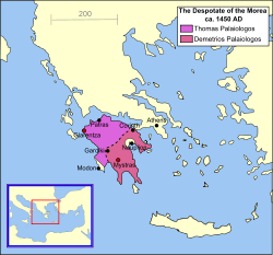
 The Despotate of the Morea in 1450, divided between the two brothers, Thomas and Demetrios Palaiologos | |||||||||
| Status | Semi-autonomous appanage of the Byzantine Empire | ||||||||
| Capital | Mystras (main capital, 1349–1460) | ||||||||
| Common languages | Medieval Greek | ||||||||
| Religion | Eastern Orthodox Church[1] | ||||||||
| Government | Feudal monarchy | ||||||||
| Despot of Morea | |||||||||
• 1349–1380 | Manuel Kantakouzenos | ||||||||
• 1449–1460 | Thomas Palaiologos and Demetrios Palaiologos | ||||||||
| Historical era | Late Medieval | ||||||||
• Established | 1349 | ||||||||
| 1453–1454 | |||||||||
| 29 May 1460 | |||||||||
| |||||||||
| Today part of | Greece | ||||||||
| History of the Byzantine Empire |
|---|
 |
| Preceding |
| Early period (330–717) |
| Middle period (717–1204) |
| Late period (1204–1453) |
| Timeline |
| By topic |
|
|
The Despotate of the Morea (Greek: Δεσποτᾶτον τοῦ Μορέως) or Despotate of Mystras (Greek: Δεσποτᾶτον τοῦ Μυστρᾶ) was a province of the Byzantine Empire which existed between the mid-14th and mid-15th centuries. Its territory varied in size during its existence but eventually grew to include almost all the southern Greek peninsula now known as the Peloponnese, which was known as the Morea during the medieval and early modern periods. The territory was usually ruled by one or more sons of the current Byzantine emperor, who were given the title of despotes (in this context it should not be confused with despotism). Its capital was the fortified city of Mystras, near ancient Sparta, which became an important centre of the Palaiologan Renaissance.
History[edit]
The Despotate of the Morea was created out of territory seized from the Frankish Principality of Achaea. This had been organized from former Byzantine territory after the Fourth Crusade (1204). In 1259, the Principality's ruler William II Villehardouin lost the Battle of Pelagonia against the Byzantine Emperor Michael VIII Palaeologus. William was forced to ransom himself by surrendering most of the eastern part of Morea and his newly built strongholds. The surrendered territory became the nucleus of the Despotate of Morea.
A later Byzantine emperor, John VI Kantakouzenos, reorganized the territory in 1349 to establish it as an appanage for his son, the Despot Manuel Kantakouzenos. For the larger portion of his reign, Manuel maintained peaceful relations with his Latin neighbors and secured a long period of prosperity for the area. Greco-Latin cooperation included an alliance to contain the raids of Murad I into Morea in the 1360s. The rival Palaiologos dynasty seized the Morea after Manuel's death in 1380, with Theodore I Palaiologos becoming despot in 1383. Theodore ruled until 1407, consolidating Byzantine rule and coming to terms with his more powerful neighbours—particularly the expansionist Ottoman Empire, whose suzerainty he recognised. He also sought to reinvigorate the local economy by inviting Albanians to settle in the territory, who developed into the Arvanite community with several leaving for the Kingdom of Naples in the 15th century and forming the Arbëresh community.
Subsequent despots were the sons of the Emperor Manuel II Palaiologos, brother of the despot Theodore: Theodore II, Constantine, Demetrios, and Thomas. As Latin power in the Peloponnese waned during the 15th century, the Despotate of the Morea expanded to incorporate the entire peninsula in 1430 with territory being acquired by dowry settlements, and the conquest of Patras by Constantine. However, in 1446 the Ottoman Sultan Murad II destroyed the Byzantine defences—the Hexamilion wall at the Isthmus of Corinth.[2] His attack opened the peninsula to invasion, though Murad died before he could exploit this. His successor Mehmed II "the Conqueror" captured the Byzantine capital Constantinople in 1453. The despots Demetrios and Thomas Palaiologos, brothers of the last emperor, failed to send him any aid, as Morea was recovering from a recent Ottoman attack. Their rule was unpopular, however, resulting in an Albanian–Greek revolt against them, during which they invited Ottoman troops to help them put down the revolt. At this time, a number of influential Greek archons made peace with Mehmed.[3] After more years of incompetent rule by the despots, their failure to pay their annual tribute to the Sultan, and finally their own revolt against Ottoman rule, Mehmed came into the Morea in May 1460. Demetrios ended up a prisoner of the Ottomans and his younger brother Thomas fled. By the end of the summer, the Ottomans had achieved the submission of virtually all cities possessed by the Greeks.
A few holdouts remained for a time. The rocky peninsula of Monemvasia refused to surrender, and it was first ruled for a brief time by a Catalan corsair. When the population drove him out, they obtained the consent of Thomas to submit to the Pope's protection before the end of 1460. The Mani Peninsula at the south end of the Morea resisted under a loose coalition of the local clans, and that area then came under Venice's rule. The last holdout was Salmeniko, in the Morea's northwest. Graitzas Palaiologos was the military commander there, stationed at Salmeniko Castle (also known as Castle Orgia). While the town eventually surrendered, Graitzas and his garrison and some town residents held out in the castle until July 1461, when they escaped and reached Venetian territory. Thus ended the last of the Byzantine Empire proper.[4][5][6][7][8][9]
After 1461, the only non-Ottoman territories were possessed by Venice: the port cities of Modon and Koroni at the southern end of the Morea, the Argolid with Argos, and the port of Nafplion. Monemvasia subsequently surrendered itself to Venice at the beginning of the 1463–1479 Ottoman–Venetian War.
Byzantine despots of the Morea[edit]
House of Kantakouzenos (1349–1383)[edit]
| Name | Reign | Relation |
|---|---|---|
| Manuel Kantakouzenos | 1349–1380 | Son of Emperor John VI Kantakouzenos |
| Matthew Kantakouzenos | 1380–1383 | Son of Emperor John VI Kantakouzenos |
| Demetrios I Kantakouzenos | 1383 | Son of Matthew |
House of Palaiologos (1383–1460)[edit]
| Name | Reign | Relation |
|---|---|---|
| Theodore I Palaiologos | 1383–1407 | Son of Emperor John V Palaiologos |
| Theodore II Palaiologos | 1407–1443 | Son of Emperor Manuel II Palaiologos |
| Constantine Palaiologos | 1428–1449 | Son of Emperor Manuel II Palaiologos; emperor from 1449 to 1453 |
| Thomas Palaiologos | 1428–1460 | Son of Emperor Manuel II Palaiologos |
| Demetrios II Palaiologos | 1449–1460 | Son of Emperor Manuel II Palaiologos |
Following the Ottoman conquest of the Morea, the title continued to be used by Thomas Palaiologos and his son Andreas in exile;
| Name | Claim | Relation |
|---|---|---|
| Thomas Palaiologos | 1460–1465 | Despot 1428–1460 |
| Andreas Palaiologos | 1465–1502 | Son of Thomas |
After the death of Andreas in 1502, the title was claimed by the Albanian exile Constantine Arianiti,[10] and by the Greek nobleman Fernando Palaiologos.[10]
See also[edit]
 Greece portal
Middle Ages portal
- Byzantine Greece
- Principality of Theodoro
- Byzantine Empire under the Palaiologos dynasty
References[edit]
Citations[edit]
- ^ Melton, J. Gordon (2014). Faiths Across Time: 5,000 Years of Religious History [4 Volumes]: 5,000 Years of Religious History. ABC-CLIO. p. 800. ISBN 9781610690263.
- ^ Rosser 2011, p. 335.
- ^ Contemporary Copy of the Letter of Mehmet II to the Greek Archons 26 December 1454 (ASV Documenti Turchi B.1/11) Archived 27 July 2013 at the Wayback Machine
- ^ Monemvasia.com website, http://www.monemvasia.com .
- ^ The Greek Travel website, http://www.thegreektravel.com/lakonia/monemvasia.html .
- ^ Katsoulakos.Com website, http://katsoulakos.com/mani-history-new.html Archived 2016-11-23 at the Wayback Machine .
- ^ Apodimos.com website, http://www.apodimos.com/arthra/07/Jan/OTTOMAN_in_the_MOREA_in_the_OUTER_MANI/index.htm Archived 2013-09-11 at the Wayback Machine .
- ^ Geni website, http://www.geni.com/people/Thomas-Palaiologos/ .
- ^ Miller, William (1907). "Monemvasia". The Journal of Hellenic Studies. 27: 229–241. doi:10.1017/S0075426900061607.
- ^ Jump up to: a b Harris, Jonathan (2013). "Despots, Emperors, and Balkan Identity in Exile". The Sixteenth Century Journal. 44 (3): 643–661. ISSN 0361-0160. JSTOR 24244808.
General and cited sources[edit]
- Rosser, John H. (2011). Historical Dictionary of Byzantium (Second ed.). Scarecrow Press. ISBN 978-0810874770.
- Runciman, Steven (2009). Lost Capital of Byzantium: The History of Mistra and the Peloponnese. Tauris Parke Paperbacks. ISBN 978-1-84511-895-2.
- Zakythinos, D.A. (1932). Le despotat grec de Morée, Tome 1: Histoire politique (in French). Paris: Société d'édition "Les Belles Lettres". OCLC 1001644255.
- Zakythinos, D.A. (1953). Le despotat grec de Morée, Tome 2: Vie et institutions (in French). Paris: Société d'édition "Les Belles Lettres". OCLC 988640826.
External links[edit]
 Media related to Despotate of the Morea at Wikimedia Commons


