Ahmadabad-e Mosaddeq
Ahmadabad-e Mosaddeq
Persian: احمداباد مصدق | |
|---|---|
Village | |
 | |
| Coordinates: 35°59′37″N 50°28′29″E / 35.99361°N 50.47472°E[1] | |
| Country | |
| Province | Alborz |
| County | Nazarabad |
| Rural District | Ahmadabad |
| Population (2016)[2] | |
| • Total | 1,603 |
| Time zone | UTC+03:30 (IRST) |
Ahmadabad-e Mosaddeq (Persian: احمداباد مصدق)[a] is a village in, and the capital of, Ahmadabad Rural District of the Central District of Nazarabad County, Alborz province, Iran,[4] 7.5 km southwest of Abyek. Mohammad Mosaddegh, former Prime Minister of Iran, is buried in Ahmadabad-e Mosaddeq.
Demographics
[edit]Population
[edit]At the time of the 2006 National Census, the village's population was 1,401 in 358 households, when it was in Tehran province.[5] The 2016 census measured the population of the village as 1,603 in 507 households, by which time the county had been separated from the province in the establishment of Alborz province.[6] It was the most populous village in its rural district.[2]
Notable people
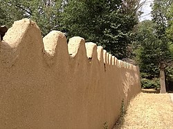
[edit]The Iranian politician Mohammad Mosaddegh spent his days of exile in his estates and is buried under his dining room. The compound has been subjected to serious deterioration, due to newly imposed government restrictions.
There was previously a high school named after Mossadegh, called Mossadegh High School, by popular vote during the period of the overthrow of the Shah in the 1970s. However, it was renamed following the denunciations against Mossadegh made by Ayatollah Khomeini. The place now stands as Emam Khomeini High School.[citation needed]
See also
[edit]Notes
[edit]References
[edit]- ^ OpenStreetMap contributors (17 August 2024). "Ahmadabad-e Mosaddeq, Nazarabad County" (Map). openstreetmap.org (OpenStreetMap) (in Persian). Retrieved 17 August 2024.
- ^ a b Census of the Islamic Republic of Iran, 1395 (2016): Alborz Province. amar.org.ir (Report) (in Persian). The Statistical Center of Iran. Archived from the original (Excel) on 28 January 2020. Retrieved 19 December 2022.
- ^ Ahmadabad-e Mosaddeq can be found at GEOnet Names Server, at this link, by opening the Advanced Search box, entering "-3765979" in the "Unique Feature Id" form, and clicking on "Search Database".
- ^ Mousavi, Mirhossein (30 September 1391) [Approved 10 April 1366]. Creation and formation of 29 rural districts including villages, farms and places in Karaj County under Tehran province. rc.majlis.ir (Report) (in Persian). Ministry of Interior, Council of Ministers. Notification 118172T943. Archived from the original on 20 December 2012. Retrieved 15 December 2023 – via The Islamic Council Research Center.
- ^ Census of the Islamic Republic of Iran, 1385 (2006): Tehran Province. amar.org.ir (Report) (in Persian). The Statistical Center of Iran. Archived from the original (Excel) on 20 September 2011. Retrieved 25 September 2022.
- ^ Larijani, Ali (2010) [Approved 16 April 1389]. Alborz province establishment law. lamtakam.com (Report) (in Persian). Guardian Council. Notification 412/30588. Archived from the original on 16 December 2023. Retrieved 21 August 2024 – via Lam ta Kam.


