Temora Shire
Appearance
| Temora Shire New South Wales | |||||||||||||||
|---|---|---|---|---|---|---|---|---|---|---|---|---|---|---|---|
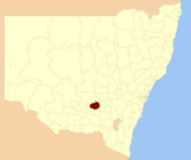
 Location in New South Wales | |||||||||||||||
| Population |
| ||||||||||||||
| • Density | 2.1806/km2 (5.648/sq mi) | ||||||||||||||
| Established | 1980 | ||||||||||||||
| Area | 2,802 km2 (1,081.9 sq mi) | ||||||||||||||
| Mayor | Cr. Rick Firman ()[3] | ||||||||||||||
| Council seat | Temora[4] | ||||||||||||||
| Region | Riverina | ||||||||||||||
| State electorate(s) | Cootamundra | ||||||||||||||
| Federal division(s) | Riverina | ||||||||||||||
 | |||||||||||||||
| Website | Temora Shire | ||||||||||||||
| |||||||||||||||
Temora Shire is a local government area in the Riverina region of New South Wales, Australia. It is on Burley Griffin Way. The Shire was created on 1 January 1981 via the amalgamation of Narraburra Shire and the Municipality of Temora.[5]
It includes the town of Temora and the small towns of Springdale, Sebastapol, Ariah Park, Gidginbung, Narraburra and Wallundry.
The mayor of Temora Shire is Cr. Rick Firman.[3]
Heritage listings
[edit]The Temora Shire has a number of heritage-listed sites, including:
- Temora, Cootamundra-Griffith railway: Temora railway station[6]
Council
[edit]Current composition and election method
[edit]Temora Shire Council is composed of nine councillors elected proportionally as a single ward. All councillors are elected for a fixed four-year term of office.[7]
Election results
[edit]| Party | Candidate | Votes | % | ±% | |
|---|---|---|---|---|---|
| Independent | Narelle Djukic | ||||
| Independent | Sigrid Carr | ||||
| Independent | Nigel Judd | ||||
| Independent | Mitchell Farlow | ||||
| Independent | Belinda Bushell | ||||
| Independent | Anthony Irvine | ||||
| Independent | Robert Matthews | ||||
| Independent National | Graham Sinclair | ||||
| Independent National | Rick Firman | ||||
| Independent | Kenneth Smith | ||||
| Independent | Martin Bushby | ||||
| Independent | Brenton Hawken | ||||
| Independent | Paul Mahon | ||||
| Independent | Dean McCrae | ||||
| Independent | Philip Bleyer | ||||
| Total formal votes | |||||
| Informal votes | |||||
| Turnout | |||||
References
[edit]- ^ Australian Bureau of Statistics (27 June 2017). "Temora (A)". 2016 Census QuickStats. Retrieved 8 December 2017.
- ^ "3218.0 – Regional Population Growth, Australia, 2017-18". Australian Bureau of Statistics. 27 March 2019. Retrieved 27 March 2019. Estimated resident population (ERP) at 30 June 2018.
- ^ a b Temora Shire Council, Current Councillors, retrieved 7 October 2016
- ^ "Temora Shire Council". Department of Local Government. Retrieved 1 December 2006.
- ^ "Past Presidents/Mayors". Temora Shire. Temora Shire Council. Retrieved 22 May 2016.
- ^ "Temora Railway Station group". New South Wales State Heritage Register. Department of Planning & Environment. H01265. Retrieved 18 May 2018.
 Text is licensed by State of New South Wales (Department of Planning and Environment) under CC-BY 4.0 licence.
- ^ "Temora Shire Council: Summary of First Preference and Group Votes for each Candidate". Local Government Elections 2016. Electoral Commission of New South Wales. 17 September 2016. Retrieved 7 October 2016.
- ^ "GRAHAM SINCLAIR". New South Wales Electoral Commission. 16 August 2024. Archived from the original on 12 September 2024. Retrieved 12 September 2024.
- ^ "RICK FIRMAN". New South Wales Electoral Commission. 16 August 2024. Archived from the original on 12 September 2024. Retrieved 12 September 2024.
34°26′S 147°32′E / 34.433°S 147.533°E
