Estaragne
| Estaragne | |
|---|---|
 | |
| Highest point | |
| Elevation | 3,006 m (9,862 ft) |
| Coordinates | 42°47′50″N 0°07′46″E / 42.79722°N 0.12944°E |
| Geography | |
| Parent range | Néouvielle massif (Pyrenees) |
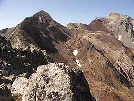
The Estaragne (Pic d'Estaragne) is a French pyrenean summit, culminating at 3,006 m (9,862 ft) m.[1][2]
Topography
[edit]The peak is located in the Hautes-Pyrénées department, in the Néouvielle massif, near Saint-Lary-Soulan in the Pyrenees National Park and near the Néouvielle National Nature Reserve.
History
[edit]The etymology of the name "Estaragne" is obscure, although there is a small valley and stream with the same name just to the northeast of the peak.[3][4]
Ecology
[edit]The peak itself is bare, but the upper slopes have a sub-alpine climate. Meadows predominate with patches of trees and shrubs.[5] Snow cover usually starts in late October and lasts until June.[6] the most common shrubs are Rhododendron ferrugineum and Vaccinium myrtillus; and the most common grasses are Nardus stricta and Festuca eskia.[5]
Access
[edit]There are at least two relatively easy summer access routes:[2]
- From the east, the shorter route, starts by leaving the sharp turn of the D 929 at the bridge crossing over the Estaragne stream, it then ascends the small hollow and turns southwards up to the col d'Estaragne.
- From the north, starting at the Cap de Long Lake, the longer route advances up valley of the Cap de Long creek.
See also
[edit]References
[edit]- ^ "Estaragne". Summitpost. Archived from the original on 8 June 2014.
- ^ a b "Pic d'Estaragne (3006m) et Pic de Campbieil (3173m) dans le massif du Néouvielle". Altituderando. Archived from the original on 9 August 2013.
- ^ Aymard, Robert (1995). Les Pyrénées au miroir de leur toponymie, volume 1 (in French). Uzos, France: Aymard. p. 83. OCLC 36130057.
- ^ Lavandier, Pierre (1974). "Ecologie d'un torrent Pyrénéen de haute montagne I. - Caractéristiques physiques". Annales de Limnologie (in French). 10 (2): 173–219. doi:10.1051/limn/1974012.
- ^ a b Pornon, André; Escaravage, Nathalie; Lamaze, Thierry (2007). "Complementarity in mineral nitrogen use among dominant plant species in a subalpine community". American Journal of Botany. 94 (11): 1778–1785. doi:10.3732/ajb.94.11.1778. PMID 21636372.
- ^ Lavandier, Pierre (1979). "Cycle biologique, régime alimentaire, production d'Arcynopteryx compacta (Plecoptera, Perlodidae) dans un torrent de haute altitude". Bulletin de la Société d'Histoire Naturelle de Toulouse (in French). 115: 140–150.
External links
[edit]- "Aerial view of Turon de Néouvielle". Google Maps.

