Tungipara Upazila
This article includes a list of general references, but it lacks sufficient corresponding inline citations. (May 2019) |
Tungipara
টুঙ্গিপাড়া | |
|---|---|
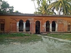
 Ancestral residence of the Sheikh–Wazed family | |
 | |
| Coordinates: 22°54′N 89°53′E / 22.900°N 89.883°E | |
| Country | |
| Division | Dhaka |
| District | Gopalganj |
| Thana | 1974 |
| Upazila | 1995 |
| Government | |
| • MP (Gopalganj-3) | Sheikh Hasina (Bangladesh Awami League) |
| • Upazila Chairman | Muhammad Sulayman Bishwas Gimadangi |
| Area | |
| • Total | 128.53 km2 (49.63 sq mi) |
| Population (2011) | |
| • Total | 100,893 |
| • Density | 780/km2 (2,000/sq mi) |
| Time zone | UTC+6 (BST) |
| Website | Tungipara Upazila |
Tungipara (Bengali: টুঙ্গিপাড়া) is an upazila of Gopalganj District in Dhaka Division, Bangladesh.[1] It is the birthplace of Sheikh Mujibur Rahman, the founder of independent Bangladesh and his grave is also here. In 1995, it was carved out of Gopalganj Sadar Upazila to become an upazila.[2]
Etymology
[edit]There is a legend that this area used to be flooded. Some saints who practiced Islam relocated to this area from Persia. They started living in this area by making canopied houses at low cost. Such houses are called "Tong" in Bengali hence the name of the place is Tungipara (Tungi+para). "Para" means neighborhood.[3]
Geography
[edit]Tungipara is located at 22°54′00″N 89°53′00″E / 22.9000°N 89.8833°E on the north-eastern bank of the Modhumoti River. It is the most southern upazila of Gopalganj District. To the north is Gopalganj Sadar, the east is Kotalipara Upazila, on the south Nazirpur Upazila in Pirojpur District and in the west is Chitalmari Upazila of Bagerhat District. Tungipara Upazila has 20,575 households and a total area of 128.53 km2.
The famous river Madhumati divides Tungipara from Bagerhat District.
Demographics
[edit]According to the 2011 Bangladesh census, Tungipara Upazila had 20,575 households and a population of 100,893. 25,517 (25.29%) were under 10 years of age. Tungipara had a literacy rate (age 7 and over) of 56.61%, compared to the national average of 51.8%, and a sex ratio of 997 females per 1000 males. 38,020 (37.68%) lived in urban areas.[4][5]
As of the 1991 Bangladesh census, Tungipara has a population of 88,102. Males constitute 51.25% of the population, and females 48.75%. This Upazila's 18+ population is 42,147. Tungipara has an average literacy rate of 63.3% (7+ years), and the national average of 32.4% literate.[6]
Points of interest
[edit]
- Mausoleum of Sheikh Mujibur Rahman
- Borni'r Baor
- Madhumati River
- Patgati Bazar
- Baghir River
Administration
[edit]Tungipara Upazila is divided into Tungipara Municipality and five union parishads: Barni, Dumuria, Gopalpur, Kushli, and Patgati. The union parishads are subdivided into 34 mauzas and 67 villages.[4]
Tungipara Municipality is subdivided into 9 wards and 13 mahallas.[4]
Education
[edit]
There are 24 mostly known educational institutes in Tungipara. It has a Government University College named Sheikh Mujibur Rahaman University college. It also has a Government high School named Gimadanga Tungipara Govt. High School.
College
[edit]- Govt. Shaikh Muzibur Rahman College, Patgati.
- Dr. Imdadul Haque Memorial Degree College, Bashbaria.
School
[edit]- Govt. Gimadanga Tungipara High School.
- Khan Saheb Sheikh Mosarrof Hossain School & College
- Guadanga Silna B.B.H High School.
- Saptapalli J. High School.
- Gopalpur Panchapalli High School.
- Nilfa Borni High School.
- Kusli Islamia High School.
- Basuria S. High School.
- Barni High School.
- Govt. Bangobandhu Smriti Girls High School.
- Gimadanga Ideal High School.
- Bashbaria Jhanjhania High School.
- Dumuria ML. High School.
- Tarail Adarsha High School.
- Baladanga SMM High School.
- Khan Saheb Sheikh Mosarraf Hossain High School.
- Begum Fatema Jr. Girls School.
- Treepalli Shaikh Abu Naser Jr. School.
- Kusli Khan Saheb Sheikh Mosarraf Hossain Jr. School.
- Patgati Jr. School.
Madrasa
[edit]- Gaohordanga Madrasa
- Darul Ulam Gaohordanga Madrasha (Kawmi)
- Bashbaria Jhanjhania Islamia Madrasha (Kawmi)
- Gimadanga Senior Madrasha (Alia)
- Gimadanga Gozalia Mohila Fazil Madrasha (Alia)
Notable people
[edit]- Abul Hassan, poet, was born at Barnigram in Tungipara in 1947.[7]
- Shamsul Haque Faridpuri, Islamic scholar.[8]
- Sheikh Hasina, Prime Minister, was born in Tungipara in 1947.[9][10]
- Sheikh Mujibur Rahman, Father of the Nation, was born in Tungipara in 1920.[11][12]
See also
[edit]References
[edit]- ^ Haldar, Poritosh (2012). "Tungipara Upazila". In Islam, Sirajul; Miah, Sajahan; Khanam, Mahfuza; Ahmed, Sabbir (eds.). Banglapedia: the National Encyclopedia of Bangladesh (Online ed.). Dhaka, Bangladesh: Banglapedia Trust, Asiatic Society of Bangladesh. ISBN 984-32-0576-6. OCLC 52727562. OL 30677644M. Retrieved 9 August 2024.
- ^ "Tungipara Upazila". Banglapedia. Retrieved 26 May 2024.
- ^ Bala, Panna (15 August 2017). "ঘুরে আসুন বঙ্গবন্ধুর স্মৃতিধন্য টুঙ্গিপাড়া". Prothom Alo (in Bengali). Retrieved 16 August 2022.
- ^ a b c d "Bangladesh Population and Housing Census 2011 Zila Report – Gopalganj" (PDF). bbs.gov.bd. Bangladesh Bureau of Statistics.
- ^ "Community Tables: Gopalganj district" (PDF). bbs.gov.bd. Bangladesh Bureau of Statistics. 2011.
- ^ "Population Census Wing, BBS". Archived from the original on 27 March 2005. Retrieved 10 November 2006.
- ^ Islam, Shahidul (2012). "Hasan, Abul". In Islam, Sirajul; Jamal, Ahmed A. (eds.). Banglapedia: National Encyclopedia of Bangladesh (Second ed.). Asiatic Society of Bangladesh.
- ^ "Faridpuri, Maulana Shamsul Haque". Banglapedia.
- ^ "Sheikh Hasina: They 'should be punished'". Al Jazeera. 23 September 2013. Retrieved 22 February 2016.
- ^ "Hasina, Sheikh". Banglapedia. Retrieved 26 May 2024.
- ^ Harun-or-Rashid (2012). "Rahman, Bangabandhu Sheikh Mujibur". In Islam, Sirajul; Jamal, Ahmed A. (eds.). Banglapedia: National Encyclopedia of Bangladesh (Second ed.). Asiatic Society of Bangladesh.
- ^ "Father of the Nation, Bangabandhu Sheikh Mujibur Rahman". guwahati.mofa.gov.bd.

