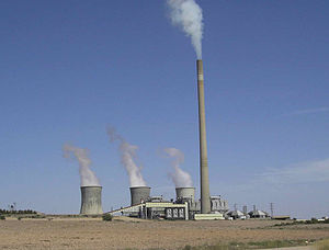
Teruel Power Plant
Appearance
| Teruel Power Plant | |
|---|---|
 | |
 | |
| Official name | Central térmica de Andorra |
| Country | Spain |
| Location | Andorra, Teruel |
| Coordinates | 40°59′50.84″N 0°22′52.23″W / 40.9974556°N 0.3811750°W |
| Status | Decommissioned |
| Commission date | 1981 |
| Decommission date |
|
| Owner(s) | Endesa |
| Operator(s) | |
| Thermal power station | |
| Primary fuel | Lignite |
| Power generation | |
| Units decommissioned | 3 x 350 MW |
| Nameplate capacity | 1,050 MW (1981-2020) |
| External links | |
| Commons | Related media on Commons |
Teruel Power Plant was a lignite fired power plant near the town of Andorra in the province of Teruel, community of Aragon, Spain. The flue gas stack of Teruel Power Plant was 343 metres (1,125 ft) high. Teruel Power Plant had three generating units with a capacity of 350 megawatts each. In 1992, Teruel Power Plant was equipped with filters that reduced the amount of detrimental sulfur dioxide emitted in the smoke by 90%.
The plant was closed in 2020.[1] On February 16, 2023, the chimney was demolished by explosives, making it the tallest freestanding structure ever demolished in a controlled manner.[2]
See also
[edit]- List of towers
- List of chimneys
- List of tallest freestanding structures in the world
- List of tallest demolished freestanding structures
References
[edit]- ^ "BOE.es - BOE-A-2020-7548 Resolución de 29 de junio de 2020, de la Dirección General de Política Energética y Minas, por la que se autoriza a Endesa Generación, SA, el cierre de la Central Térmica de Teruel, en el término municipal de Andorra (Teruel)". www.boe.es. Retrieved 2021-05-27.
- ^ "Derrumbe chimenea central Andorra (Teruel)". YouTube. 16 February 2023.
External links
[edit]Categories:
- 1981 establishments in Spain
- 2020 disestablishments in Spain
- Energy infrastructure completed in 1981
- Towers completed in 1981
- Coal-fired power stations in Spain
- Chimneys in Spain
- Buildings and structures in the Province of Teruel
- Former power stations in Spain
- Former coal-fired power stations
- Power station stubs
- Spanish building and structure stubs
