Xuyong County
Appearance
Xuyong County
叙永县 | |
|---|---|
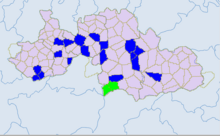
 Location of Xuyong County (red) within Luzhou City (yellow) and Sichuan | |
| Coordinates: 28°09′21″N 105°26′41″E / 28.1558°N 105.4448°E | |
| Country | China |
| Province | Sichuan |
| Prefecture-level city | Luzhou |
| County seat | Xuyong Town |
| Area | |
| • Total | 2,977 km2 (1,149 sq mi) |
| Population (2018)[1] | |
| • Total | 582,000 |
| • Density | 200/km2 (510/sq mi) |
| Time zone | UTC+8 (China Standard) |

Xuyong County (simplified Chinese: 叙永县; traditional Chinese: 敘永縣; pinyin: Xùyǒng Xiàn) is a county in the southeast of Sichuan Province, China, bordering the provinces of Guizhou to the south and Yunnan to the west. It is under the administration of the prefecture-level city of Luzhou. The county covers 2,977 km2 (1,149 sq mi) with a population of 688,200 in 2007.[citation needed]
Administrative divisions
[edit]Xuyong County comprises 18 towns and 5 ethnic townships:[2]
- towns
- Xuyong Town (叙永镇)
- Jiangmen Town (江门镇)
- Maling Town (马岭镇)
- Tianchi Town (天池镇)
- Shuiwei Town (水尾镇)
- Lianghe Town (两河镇)
- Luobu Town (落卜镇)
- Houshan Town (后山镇)
- Fenshui Town (分水镇)
- Moni Town (摩尼镇)
- Chishui Town (赤水镇)
- Longfeng Town (龙凤镇)
- Zhengdong Town (正东镇)
- Guanxing Town (观兴镇)
- Xianglin Town (向林镇)
- Macheng Town (麻城镇)
- Dashi Town (大石镇)
- Huangni Town (黄坭镇)
- ethnic townships
- Hele Miao Ethnic Township (合乐苗族乡, Wuab Lob Hmongb Xangb)
- Baila Miao Ethnic Township (白腊苗族乡)
- Jiancao Miao Ethnic Township (枧槽苗族乡, Lob Hmongb Xangb Hangd Ynaf)
- Shuiliao Yi Ethnic Township (水潦彝族乡, ꎶꆂꆈꌠꑣ)
- Shixiangzi Yi Ethnic Township (石厢子彝族乡)
Climate
[edit]| Climate data for Xuyong, elevation 378 m (1,240 ft), (1991–2020 normals, extremes 1981–2010) | |||||||||||||
|---|---|---|---|---|---|---|---|---|---|---|---|---|---|
| Month | Jan | Feb | Mar | Apr | May | Jun | Jul | Aug | Sep | Oct | Nov | Dec | Year |
| Record high °C (°F) | 20.9 (69.6) |
27.7 (81.9) |
37.0 (98.6) |
36.4 (97.5) |
40.3 (104.5) |
40.3 (104.5) |
41.0 (105.8) |
42.6 (108.7) |
42.9 (109.2) |
34.1 (93.4) |
29.5 (85.1) |
21.8 (71.2) |
42.9 (109.2) |
| Mean daily maximum °C (°F) | 10.9 (51.6) |
14.0 (57.2) |
19.0 (66.2) |
24.5 (76.1) |
27.6 (81.7) |
29.5 (85.1) |
33.0 (91.4) |
33.2 (91.8) |
28.1 (82.6) |
21.9 (71.4) |
17.8 (64.0) |
12.2 (54.0) |
22.6 (72.8) |
| Daily mean °C (°F) | 8.1 (46.6) |
10.4 (50.7) |
14.4 (57.9) |
19.2 (66.6) |
22.4 (72.3) |
24.6 (76.3) |
27.6 (81.7) |
27.5 (81.5) |
23.5 (74.3) |
18.4 (65.1) |
14.3 (57.7) |
9.4 (48.9) |
18.3 (65.0) |
| Mean daily minimum °C (°F) | 6.3 (43.3) |
8.1 (46.6) |
11.4 (52.5) |
15.7 (60.3) |
18.8 (65.8) |
21.4 (70.5) |
23.8 (74.8) |
23.7 (74.7) |
20.6 (69.1) |
16.3 (61.3) |
12.1 (53.8) |
7.6 (45.7) |
15.5 (59.9) |
| Record low °C (°F) | −0.4 (31.3) |
0.5 (32.9) |
1.4 (34.5) |
6.7 (44.1) |
10.4 (50.7) |
15.0 (59.0) |
16.7 (62.1) |
17.2 (63.0) |
13.9 (57.0) |
6.1 (43.0) |
3.0 (37.4) |
−1.5 (29.3) |
−1.5 (29.3) |
| Average precipitation mm (inches) | 38.2 (1.50) |
31.1 (1.22) |
55.4 (2.18) |
82.6 (3.25) |
131.5 (5.18) |
182.0 (7.17) |
157.5 (6.20) |
168.4 (6.63) |
108.5 (4.27) |
95.0 (3.74) |
48.3 (1.90) |
39.1 (1.54) |
1,137.6 (44.78) |
| Average precipitation days (≥ 0.1 mm) | 16.9 | 13.5 | 15.5 | 14.9 | 16.0 | 18.2 | 14.5 | 13.1 | 14.9 | 19.3 | 14.5 | 15.7 | 187 |
| Average snowy days | 0.4 | 0 | 0 | 0 | 0 | 0 | 0 | 0 | 0 | 0 | 0 | 0.1 | 0.5 |
| Average relative humidity (%) | 83 | 80 | 77 | 75 | 75 | 80 | 76 | 74 | 80 | 85 | 84 | 85 | 80 |
| Mean monthly sunshine hours | 36.3 | 46.8 | 85.5 | 121.5 | 124.9 | 112.0 | 185.3 | 189.8 | 114.1 | 59.7 | 60.5 | 37.5 | 1,173.9 |
| Percent possible sunshine | 11 | 15 | 23 | 31 | 30 | 27 | 44 | 47 | 31 | 17 | 19 | 12 | 26 |
| Source: China Meteorological Administration[3][4] | |||||||||||||
References
[edit]- ^ "Xùyŏng Xiàn (County, China) - Population Statistics, Charts, Map and Location".
- ^ 2023年统计用区划代码和城乡划分代码:叙永县 (in Simplified Chinese). National Bureau of Statistics of China.
- ^ 中国气象数据网 – WeatherBk Data (in Simplified Chinese). China Meteorological Administration. Retrieved 14 April 2023.
- ^ 中国气象数据网 (in Simplified Chinese). China Meteorological Administration. Retrieved 14 April 2023.
External links
[edit]
