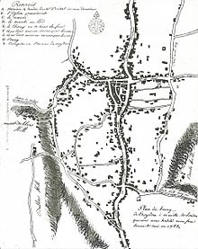
Old Town, Croydon

Old Town is a neighbourhood in the London Borough of Croydon, lying immediately to the west of Croydon town centre. It is centred on Croydon Minster and the Old Palace, and is the location of the original early medieval settlement of Croydon. As defined for modern planning purposes, the neighbourhood includes Surrey Street Market to the east, and extends west as far as the boundaries of Wandle Park, and south to Croydon Flyover (part of the east–west A232 road). It is bisected by the dual-carriageway north–south A236, known along this stretch as Roman Way.[1] It is in the CR0 postcode area.
History
[edit]
A Roman road, the London to Portslade Way, is known to have passed through what is now Croydon, but its precise route is debated. One suggestion is that it ran through Old Town, and it is in acknowledgement of this theory that the local section of the A236 dual carriageway was named Roman Way in the 1960s. The argument is by no means universally accepted, however, and it is equally possible that the Roman road was situated on the higher ground to the east, running along what is now North End, High Street and South End in central Croydon.[3]
A settlement developed at Croydon in the mid-to-late Anglo-Saxon period, around the parish church (now Croydon Minster) and the manor house of the Archbishops of Canterbury (Croydon Palace, now occupied by Old Palace School). However, in 1276 Archbishop Robert Kilwardby acquired a charter for a weekly market, and, probably in association with this charter, laid out a new market place on the higher ground to the east, in the triangle now bounded by High Street, Surrey Street and Crown Hill.[4] Croydon's commercial and social focus therefore also shifted east, leaving Old Town on its periphery. The earliest occurrences of the name "Old Town" ("Vetere Croyndon" or "vetire villa") date from the 1280s, implying that the locality was already seen as subsidiary to the "new town" around the market and High Street.[5] The area was also prone to flooding from the River Wandle, and in the early modern period declined further into a partial slum area. The archbishops sold the palace in 1781, purchasing instead a new residence at Addington.
Present day
[edit]
The Old Town area now has a large residential and business community.[1] There are two secondary schools in the locality: Old Palace School and The Write Time School, which occupies the buildings of the former St Andrew's Church of England High School. Old Town is also home to Croydon town centre's main fire station.[1]
The area partially overlaps with three conservation areas: the Croydon Minster Conservation Area, the Church Street Conservation Area, and the Central Croydon Conservation Area.[1][6]
A prominent local business is the House of Reeves, an independent furniture store founded in 1867, which gives its name to the road intersection of Reeves Corner, between Church Street and Roman Way. The company came to widespread national public attention in August 2011, when one of its buildings was destroyed in an arson attack during the 2011 England riots.[7]
In 2017 the area was the site of a council-funded tech incubator scheme, with several companies relocating from central London.[8]
Nearest stations
[edit]- Reeves Corner tram stop
- Church Street tram stop
- Wandle Park tram stop
- West Croydon station
- Waddon railway station
References
[edit]- ^ a b c d "Old Town masterplan". Croydon.gov.uk. 1 December 2014. Retrieved 2 July 2023.
- ^ Lancaster, Brian (March 2012). "Jean-Baptiste Say's 1785 Croydon street plan". Croydon Natural History & Scientific Society Bulletin. 144: 2–5.
- ^ Maggs, Ken; De'Athe, Paul (1987). The Roman Roads of East Surrey and the Kent Border. Westerham: North Downs Press. pp. 40–44.
- ^ Harris, Oliver (2005). The Archbishops' Town: the making of medieval Croydon. Croydon: Croydon Natural History and Scientific Society. pp. 253–6. ISBN 0-906047-20-X.
- ^ Harris 2005, p. 254.
- ^ Thornhill, Lilian (1987). Conservation Areas of Croydon. Croydon: Croydon Society. pp. 8–13, 36–44. ISBN 0-9512713-0-X.
- ^ Adams, William Lee ( (11 August 2011). "The London Riots: how the community of Croydon consumed itself". Time. Archived from the original on 12 August 2011. Retrieved 11 February 2018.
- ^ "Moving out: London's up-and-coming office locations". Propertyweek.com. Retrieved 29 January 2018.


