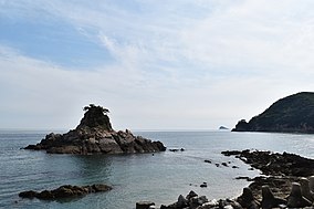
Taeanhaean National Park
| Taean Seaside National Park | |
|---|---|
| 태안해안국립공원, 泰安海岸國立公園 | |
 | |
| Coordinates | 36°47′14″N 126°08′37″E / 36.78722°N 126.14361°E |
| Area | 326 sq mi (840 km2) |
| Established | 20 October 1978 |
| Governing body | Korea National Park Service |
 | |
Land-based parks are in red and marine parks are in blue.
Taean Seaside National Park (Korean: 태안해안국립공원; Hanja: 泰安海岸國立公園) in Taean County, South Chungcheong Province, South Korea. It was designated the country's 13th National Park in 1978. The total area is about 326 sq mi (840 km2), with 289.315 sq mi (749.32 km2) being marine area.
It contains various coastal ecosystems and variety of coastal landmarks such as 26 beaches, sand dunes, rocky formations, and 72 islands along the 230 km coastline.
Regarding the natural resources, 1,195 animal species, 774 plant species, and 671 marine species including minke whales[1][2][3] and finless porpoises[4] are distributed within this national park. Endangered species include Eurasian otter, Chinese egret, Eremias argus, and the Seoul frog, Ranunculus kazusensis.
References
[edit]- ^ Naver. 2012. 태안 갯벌에 밍크고래가‥주민 도움으로 바다로. Retrieved on October 07, 2017
- ^ 왕성상. 2012. 서해안 태안 갯벌로 떠밀려온 밍크고래들. 아시아경제. Retrieved on October 07, 2017
- ^ 2012. 5시간여 만에 바다로 돌아간 태안앞바다 밍크 고래. JTBC 뉴스. Retrieved on October 07, 2017
- ^ 전종선 기자. 2016. ‘웃는 고래 상괭이’, 태안 앞바다서 100마리 규모 발견. Sedaily.com. Retrieved on October 07, 2017
- Korea National Park Service. 2008. National Parks of Korea
- http://english.knps.or.kr/Knp/Taeanhaean/Intro/Introduction.aspx?MenuNum=1&Submenu=Npp
External links
[edit]- The park's page on Korea National Park Service's website
- Taean Sinduri coastal sand dunes
- Taean Peninsula

