McKinley River
Appearance
| McKinley River | |
|---|---|
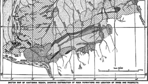
 Kantishna Region Geologic map showing the location of the Muldrow Glacier origin of the river | |
| Location | |
| Country | United States |
| State | Alaska |
| District | Denali Borough |
| Physical characteristics | |
| Source | Muldrow Glacier |
| • location | Denali National Park and Preserve |
| • coordinates | 63°21′51″N 150°25′59″W / 63.36417°N 150.43306°W[1] |
| • elevation | 3,117 ft (950 m)[2] |
| Mouth | Kantishna River[3] |
• location | confluence with Birch Creek, 23 miles (37 km) east of Lake Minchumina |
• coordinates | 63°51′59″N 151°33′20″W / 63.86639°N 151.55556°W[1] |
• elevation | 646 ft (197 m)[1] |
| Length | 58 mi (93 km)[3] |
The McKinley River (Lower Tanana: Henteel no' Tl'o) is a 58-mile (93 km) tributary of the Kantishna River in central Alaska in the United States.[3] It drains an area on the north slope of the Alaska Range on the south edge of the Tanana Valley southwest of Fairbanks.[4] The river issues from Muldrow Glacier in the northern Alaska Range in Denali National Park and Preserve, northeast of Denali.[4] It flows through the tundra north of the Alaska Range in a generally northwest direction, joining Birch Creek to form the Kantishna River near Chilchukabena Lake.[4]
The river was named McKinley Fork by A.H. Brooks in 1905. Other names or variants include Henteeth No' Tl'o and Hintusno' Dikats.[1]
See also
[edit]References
[edit]- ^ a b c d "McKinley River". Geographic Names Information System. United States Geological Survey. March 31, 1981. Retrieved October 20, 2013.
- ^ Derived by entering source coordinates in Google Earth.
- ^ a b c Orth, Donald J.; United States Geological Survey (1971) [1967]. Dictionary of Alaska Place Names: Geological Survey Professional Paper 567 (PDF). University of Alaska Fairbanks. p. 611. Archived from the original (PDF) on October 17, 2013. Retrieved October 15, 2013.
{{cite book}}: Unknown parameter|agency=ignored (help) - ^ a b c Alaska Atlas & Gazetteer (7th ed.). Yarmouth, Maine: DeLorme. 2010. pp. 102–03. ISBN 978-0-89933-289-5.

