Mirpur Khas District
Mirpur Khas District
ضلع میرپور خاص ميرپور خاص ضلعو | |
|---|---|
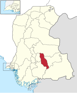
 Location of Mirpurkhas in Sindh province | |
| Coordinates: 25°33′02″N 069°00′11″E / 25.55056°N 69.00306°E | |
| Country | |
| Province | |
| Division | Mirpur Khas |
| Established | 31 October 1990 |
| Headquarters | Mirpur Khas |
| Government | |
| • Type | District Administration |
| • Deputy Commissioner | Zain Ul Abideen Memon |
| • District Police Officer | N/A |
| • District Health Officer | N/A |
| Area | |
| • Total | 2,925 km2 (1,129 sq mi) |
| Population | |
| • Total | 1,681,386 |
| • Density | 570/km2 (1,500/sq mi) |
| Time zone | UTC+5 (PST) |
| Number of Tehsils | 7 |
Mirpur Khas District (Sindhi: ضلعو ميرپورخاص, Urdu: ضلع مِيرپورخاص) is one of the districts in the province of Sindh, Pakistan. Its capital is Mirpur Khas city.[2]
Administrative divisions
[edit]The district of Mirpur Khas is sub-divided into 7 tehsils:[3]
- Digri Tehsil
- Kot Ghulam Muhammad Tehsil
- Mirpur Khas Tehsil
- Jhuddo Tehsil
- Sindhri Tehsil
- Hussain Bux Mari Tehsil
- Shujabad Tehsil
History
[edit]
After the capture of Sindh by the British, In 1882 they created Thar and Parkar District in Southeastern Sindh for administrative purposes. In 1906, the district headquarters was moved from Amarkot (now Umerkot) to Mirpur Khas. In 1953, after the creation of Pakistan, some area on the northern side was detached from the original Tharparkar District and named Sanghar District. On 31 October 1990 the district was divided into the Tharparkar and Mirpur Khas Districts. In the same year, Mirpur Khas also get the status of divisional headquarter.
Mirpur Khas District derives its name from the town of Mirpur Khas, founded by Mir Ali Murad Talpur in 1806.
Demographics
[edit]At the time of the 2017 census, Mirpur Khas district had 284,647 households and a population of 1,504,440. Mirpur Khas had a sex ratio of 938 females per 1000 males and a literacy rate of 42.41%: 52.94% for males and 31.22% for females. 434,081 (28.85%) lived in urban areas. 467,853 (31.10%) were under 10 years of age.[5] In 2023, the district had 313,141 households and a population of 1,681,386.[1]
Religion
[edit]The majority religion is Islam, with 60.75% of the population. Hinduism (including those from Scheduled Castes) is practiced by 38.74% of the population. In rural areas, Muslims and Hindus are in nearly equal numbers.[5]
| Circle | Muslims | Hindus | Others |
|---|---|---|---|
| Digri | 59.76% | 40.13% | 0.11% |
| Hussain Bux Mari | 61.24% | 38.60% | 0.16% |
| Jhudo | 56.68% | 42.92% | 0.40% |
| Kot Ghulam Muhammad | 45.37% | 54.51% | 0.12% |
| Mirpur Khas | 89.04% | 9.03% | 1.93% |
| Shujabad | 52.27% | 47.29% | 0.44% |
| Sindhri | 57.51% | 42.43% | 0.06% |
Language
[edit]At the time of the 2017 census, 75.78% of the population spoke Sindhi, 12.23% Urdu, 7.48% Punjabi and 1.25% Balochi as their first language.[5]
See also
[edit]References
[edit]- ^ a b "TABLE 1 : HOUSEHOLDS, POPULATION, HOUSEHOLD SIZE AND ANNUAL GROWTH RATE" (PDF). www.pbscensus.gov.pk. Pakistan Bureau of Statistics. 2023.
- ^ "Sindh Province: 7 Districts of Sindh (2015) including Mirpur Khas District" (PDF). Election Commission of Pakistan website. 3 September 2015. Archived from the original (PDF) on 23 November 2015. Retrieved 9 December 2023.
- ^ Correspondent, The Newspaper's (13 December 2012). "New taluka in Mirpurkhas notified". DAWN.COM. Retrieved 16 January 2024.
- ^ Menon, Sunita. "Queen of Mangoes: Sindhri from Pakistan now in UAE". Khaleej Times. Retrieved 22 September 2019.
- ^ a b c d "District Wise Results / Tables (Census - 2017)". www.pbscensus.gov.pk. Pakistan Bureau of Statistics.
External links
[edit]


