Duizel
Duizel | |
|---|---|
Village | |
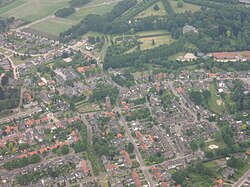
 Aerial view of Duizel | |
| Coordinates: 51°22′N 5°18′E / 51.367°N 5.300°E | |
| Country | |
| Province | |
| Municipality | |
| Area | |
| • Total | 6.54 km2 (2.53 sq mi) |
| Elevation | 29 m (95 ft) |
| Population (2021)[1] | |
| • Total | 2,000 |
| • Density | 310/km2 (790/sq mi) |
| Time zone | UTC+1 (CET) |
| • Summer (DST) | UTC+2 (CEST) |
| Postal code | 5525[1] |
| Dialing code | 0497 |
Duizel is a village in the municipality of Eersel in the province of North Brabant, the Netherlands. Duizel is part of the Acht Zaligheden (Eight Beatitudes), like Eersel, Knegsel, Steensel, Wintelre, Netersel, Hulsel and Reusel.
The village was first mentioned before 1026 as Duselam, and named after a gentle flowing stream.[3] Duizel is a road village which developed along the Kleine Beerze.[4]
The tower of the St John Church dates from the 15th century. The matching church was demolished in 1927. The St John's Birth Church was built in 1925 in basilica style.[4]
During the 19th century, Duizel developed into a centre for the cigar industry.[4] Duizel was home to 296 people in 1840. It was part of the municipality of Duizel en Steensel until 1922 when it was merged into Eersel.[5]
Gallery
[edit]-
Duizel
-
Bandstand
-
House in Duizel
-
House in Duizel
References
[edit]- ^ a b c "Kerncijfers wijken en buurten 2021". Central Bureau of Statistics. Retrieved 16 April 2022.
- ^ "Postcodetool for 5525AA". Actueel Hoogtebestand Nederland (in Dutch). Het Waterschapshuis. Retrieved 16 April 2022.
- ^ "Duizel - (geografische naam)". Etymologiebank (in Dutch). Retrieved 16 April 2022.
- ^ a b c Chris Kolman & Ronald Stenvert (1997). Duizel (in Dutch). Zwolle: Waanders. ISBN 90 400 9945 6. Retrieved 16 April 2022.
- ^ "Duizel". Plaatsengids (in Dutch). Retrieved 16 April 2022.


