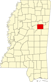
[ 3] Name on the Register[ 4]
Image
Date listed[ 5]
Location
City or town
Description
1
Bardwell House Upload image July 16, 1992 (#92000890 ) 309 Blackjack Road 33°26′53″N 88°46′56″W / 33.448056°N 88.782222°W / 33.448056; -88.782222 (Bardwell House ) Starkville Demolished
2
Bell House Upload image October 29, 1992 (#92001480 ) 1280 Mississippi Highway 25 , S. 33°26′11″N 88°49′06″W / 33.436389°N 88.818333°W / 33.436389; -88.818333 (Bell House ) Starkville
3
Thomas Battle Carroll House Thomas Battle Carroll House May 1, 1991 (#91000531 ) 304 S. Jackson St. 33°27′36″N 88°48′51″W / 33.46°N 88.814167°W / 33.46; -88.814167 (Thomas Battle Carroll House ) Starkville
4
The Cedars The Cedars October 10, 1985 (#85003003 ) 607 Old West Point Rd. 33°28′31″N 88°48′04″W / 33.475278°N 88.801111°W / 33.475278; -88.801111 (The Cedars ) Starkville
5
Downtown Starkville Historic District Upload image July 25, 2012 (#12000433 ) Roughly bounded by Jefferson, N. Montgomery, & Yeates Sts., & railroad 33°27′48″N 88°48′52″W / 33.463311°N 88.81453°W / 33.463311; -88.81453 (Downtown Starkville Historic District ) Starkville
6
C. E. Gay House C. E. Gay House January 3, 1991 (#90002108 ) 110 E. Gillespie St. 33°27′28″N 88°48′55″W / 33.457778°N 88.815278°W / 33.457778; -88.815278 (C. E. Gay House ) Starkville
7
Gillespie-Jackson House Upload image November 6, 1986 (#86003127 ) 701 Louisville 33°27′13″N 88°49′17″W / 33.453611°N 88.821389°W / 33.453611; -88.821389 (Gillespie-Jackson House ) Starkville Demolished
8
Greensboro Street Historic District Upload image June 14, 1982 (#82003112 ) Greensboro St.; also Ernest Jones Jr. Dr., Greensboro St., Louisville St., Main St., W., Raymond St., and Yeates St. 33°27′42″N 88°49′29″W / 33.461667°N 88.824722°W / 33.461667; -88.824722 (Greensboro Street Historic District ) Starkville Second set of boundaries represents a boundary increase of July 10, 2008
9
Herman Mound and Village Site Upload image March 17, 1993 (#93000137 ) Address restricted[ 6] Starkville
10
Hotel Chester Hotel Chester January 18, 1985 (#85000099 ) 217-223 E. Main St. 33°27′50″N 88°48′51″W / 33.463889°N 88.814167°W / 33.463889; -88.814167 (Hotel Chester ) Starkville
11
Lampkin-Owens House Lampkin-Owens House November 24, 1980 (#80002298 ) 117 N. Montgomery St. 33°27′56″N 88°48′38″W / 33.465556°N 88.810556°W / 33.465556; -88.810556 (Lampkin-Owens House ) Starkville
12
Lyon's Bluff Site Upload image April 22, 1976 (#76001105 ) Address restricted[ 6] Starkville
13
Magruder-Newsom House Upload image August 30, 1984 (#84002284 ) 306 S. Jackson St. 33°27′36″N 88°48′51″W / 33.46°N 88.814167°W / 33.46; -88.814167 (Magruder-Newsom House ) Starkville
14
Meadow Woods Plantation House Upload image September 7, 2001 (#01000946 ) 2479 Oktoc Rd. 33°22′04″N 88°45′43″W / 33.367778°N 88.761944°W / 33.367778; -88.761944 (Meadow Woods Plantation House ) Starkville
15
Montgomery Hall Montgomery Hall March 26, 1975 (#75001054 ) Mississippi State University campus33°27′13″N 88°47′29″W / 33.453611°N 88.791389°W / 33.453611; -88.791389 (Montgomery Hall ) Starkville Constructed 1902-03 using Beaux-Arts architectural style[ 7]
16
Nash Street Historic District Upload image June 24, 1993 (#93000572 ) 525 University Dr. and 101-117 N. Nash St. 33°27′47″N 88°48′14″W / 33.463056°N 88.803889°W / 33.463056; -88.803889 (Nash Street Historic District ) Starkville
17
Odd Fellows Cemetery Odd Fellows Cemetery July 24, 1990 (#90001064 ) Junction of U.S. Route 82 and Henderson St. 33°28′00″N 88°49′15″W / 33.466667°N 88.820833°W / 33.466667; -88.820833 (Odd Fellows Cemetery ) Starkville
18
Oktibbeha Gardens Subdivision Historic District Upload image September 28, 2017 (#100001682 ) Roughly bounded by Critz & N. Montgomery Sts., Old West Point Rd. & Dr. Martin Luther King Jr. Dr. E. 33°28′08″N 88°48′29″W / 33.468971°N 88.808108°W / 33.468971; -88.808108 (Oktibbeha Gardens Subdivision Historic District ) Starkville
19
Dossey A. Outlaw Plantation Dossey A. Outlaw Plantation April 11, 2002 (#02000354 ) 6114 Oktoc Rd. 33°23′07″N 88°46′27″W / 33.385278°N 88.774167°W / 33.385278; -88.774167 (Dossey A. Outlaw Plantation ) Starkville
20
Overstreet School Historic District Upload image October 23, 1992 (#92001398 ) Roughly bounded by Hogan, Montgomery, Gillespie, Jackson, Wood, and Washington Sts. and the Illinois Central railroad tracks 33°27′34″N 88°48′48″W / 33.459444°N 88.813333°W / 33.459444; -88.813333 (Overstreet School Historic District ) Starkville
21
Emma and Ed Rogers House Emma and Ed Rogers House September 28, 2017 (#100001684 ) 1245 Longview Rd. 33°24′16″N 88°51′29″W / 33.404444°N 88.858056°W / 33.404444; -88.858056 (Emma and Ed Rogers House ) Starkville
22
Starkville Colored Cemetery Starkville Colored Cemetery June 2, 2014 (#14000277 ) N. side of University Dr., W. of N. Nash & E. of Hartness Sts. 33°27′46″N 88°48′25″W / 33.462908°N 88.806842°W / 33.462908; -88.806842 (Starkville Colored Cemetery ) Starkville
23
John M. Stone Cotton Mill John M. Stone Cotton Mill April 29, 1975 (#75001055 ) 600 Russell St. 33°27′26″N 88°48′09″W / 33.457222°N 88.8025°W / 33.457222; -88.8025 (John M. Stone Cotton Mill ) Starkville
24
Textile Building Textile Building May 12, 1975 (#75001056 ) South of Starkville on the Mississippi State University campus 33°27′08″N 88°47′30″W / 33.452222°N 88.791667°W / 33.452222; -88.791667 (Textile Building ) Starkville Constructed in 1900 using Italianate , Mission & Romanesque architectural styles. Oldest academic building on the Mississippi State University campus.[ 8]
25
Walker-Critz House Walker-Critz House March 22, 1989 (#89000171 ) 414 Chapin St. 33°28′01″N 88°48′29″W / 33.466944°N 88.808056°W / 33.466944; -88.808056 (Walker-Critz House ) Starkville


