[ 3] Name on the Register[ 4]
Image
Date listed[ 5]
Location
City or town
Description
1
7-D School 7-D School December 22, 2009 (#09001120 ) County Road 171 north of County Road 50.6 37°21′29″N 103°35′35″W / 37.358067°N 103.593011°W / 37.358067; -103.593011 (7-D School ) Branson
2
Aultman House Aultman House July 11, 2007 (#07000673 ) 37°10′31″N 104°30′59″W / 37.175278°N 104.516389°W / 37.175278; -104.516389 (Aultman House ) Trinidad
3
Baca House and Outbuilding Baca House and Outbuilding February 26, 1970 (#70000165 ) 300 block of Main St. 37°10′09″N 104°30′09″W / 37.169167°N 104.5025°W / 37.169167; -104.5025 (Baca House and Outbuilding ) Trinidad Now part of the Trinidad History Museum
4
Frank G. Bloom House Frank G. Bloom House February 26, 1970 (#70000166 ) 300 block of Main St. 37°10′10″N 104°30′07″W / 37.169444°N 104.501944°W / 37.169444; -104.501944 (Frank G. Bloom House ) Trinidad Now part of the Trinidad History Museum
5
Bridge over Burro Canon Bridge over Burro Canon February 4, 1985 (#85000216 ) State Highway 12 37°07′26″N 104°44′26″W / 37.123889°N 104.740556°W / 37.123889; -104.740556 (Bridge over Burro Canon ) Madrid
6
Carnegie Public Library Carnegie Public Library April 14, 1995 (#95000438 ) 202 N. Animas St. 37°10′05″N 104°30′28″W / 37.168056°N 104.507778°W / 37.168056; -104.507778 (Carnegie Public Library ) Trinidad
7
Cokedale Historic District Cokedale Historic District January 18, 1985 (#85000083 ) Roughly bounded by Church, Maple, Pine, Elm, and Spruce Sts. 37°08′32″N 104°37′10″W / 37.142222°N 104.619444°W / 37.142222; -104.619444 (Cokedale Historic District ) Cokedale
8
Colorado Millennial Site Colorado Millennial Site April 8, 1980 (#80000877 ) At the source of Rule Creek, 2 miles (3.2 km) south of the junction of Baca, Bent, and Las Animas counties[ 6] 37°37′01″N 103°04′43″W / 37.6169467°N 103.0786585°W / 37.6169467; -103.0786585 (Colorado Millennial Site ) Ruxton Extends into Baca County
9
Corazon de Trinidad Corazon de Trinidad February 28, 1973 (#73000482 ) Roughly bounded by the Purgatoire River on the north and west, Walnut St. on the east, and 3rd, W. 1st and Animas Sts. on the south 37°10′07″N 104°30′20″W / 37.168611°N 104.505556°W / 37.168611; -104.505556 (Corazon de Trinidad ) Trinidad
10
Earl School Earl School October 23, 2013 (#13000844 ) Address Restricted Earl Part of the Rural School Buildings in Colorado MPS
11
East Street School East Street School December 19, 2007 (#07001277 ) 206 East St. 37°10′15″N 104°29′43″W / 37.170833°N 104.495278°W / 37.170833; -104.495278 (East Street School ) Trinidad
12
Charles Emerick House Charles Emerick House March 18, 2014 (#14000059 ) 1211 Nevada Ave. 37°10′47″N 104°30′38″W / 37.179612°N 104.510464°W / 37.179612; -104.510464 (Charles Emerick House ) Trinidad
13
First Baptist Church First Baptist Church January 28, 2000 (#00000005 ) 809 San Pedro St. 37°10′31″N 104°30′27″W / 37.175278°N 104.5075°W / 37.175278; -104.5075 (First Baptist Church ) Trinidad
14
First Christian Church First Christian Church November 7, 1995 (#95001246 ) 200 S. Walnut St. 37°10′08″N 104°30′02″W / 37.168889°N 104.500556°W / 37.168889; -104.500556 (First Christian Church ) Trinidad
15
First Methodist Episcopal Church First Methodist Episcopal Church August 7, 2005 (#05000783 ) 216 Broom St. 37°10′25″N 104°30′38″W / 37.173611°N 104.510556°W / 37.173611; -104.510556 (First Methodist Episcopal Church ) Trinidad
16
Foster House Stage Station and Hotel Site Foster House Stage Station and Hotel Site March 31, 2015 (#15000110 ) Address Restricted Aguilar
17
Jaffa Opera House Jaffa Opera House February 7, 1972 (#72000275 ) 100-116 W. Main St. 37°10′05″N 104°30′19″W / 37.168056°N 104.505278°W / 37.168056; -104.505278 (Jaffa Opera House ) Trinidad
18
Kim Schools Kim Schools April 24, 2007 (#07000342 ) 425 State St. 37°14′49″N 103°21′10″W / 37.246944°N 103.352778°W / 37.246944; -103.352778 (Kim Schools ) Kim
19
Frank Latuda House Frank Latuda House January 27, 2010 (#09001275 ) 431 W. Colorado Ave. 37°10′31″N 104°30′47″W / 37.175164°N 104.512917°W / 37.175164; -104.512917 (Frank Latuda House ) Trinidad
20
Ludlow Tent Colony Site Ludlow Tent Colony Site June 19, 1985 (#85001328 ) Del Aqua Canyon Rd. 37°20′22″N 104°35′00″W / 37.339443°N 104.583336°W / 37.339443; -104.583336 (Ludlow Tent Colony Site ) Ludlow Site of the nineteenth-century Ludlow massacre of rioting miners, recently yielding archeological findings. Declared a National Historical Landmark in 2009.
21
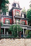
McCormick House McCormick House November 4, 2009 (#09000869 ) 1919 Pinon St. 37°10′56″N 104°31′14″W / 37.18222°N 104.52051°W / 37.18222; -104.52051 (McCormick House ) Trinidad Large Queen Anne house completed in 1891.
22
Monument Lake Park Building and Hatchery Complex Monument Lake Park Building and Hatchery Complex November 24, 2014 (#14000950 ) 4789 CO 12 37°12′38″N 105°02′51″W / 37.2105°N 105.0474°W / 37.2105; -105.0474 (Monument Lake Park Building and Hatchery Complex ) Weston
23
Nichols House Nichols House August 30, 2005 (#05000930 ) 212 E. 2nd St. 37°10′02″N 104°30′07″W / 37.167222°N 104.501944°W / 37.167222; -104.501944 (Nichols House ) Trinidad
24
Our Lady of Guadalupe Church and Medina Cemetery Our Lady of Guadalupe Church and Medina Cemetery November 15, 2019 (#100004628 ) CO Hwy. 12 37°07′45″N 104°47′59″W / 37.129112°N 104.799595°W / 37.129112; -104.799595 (Our Lady of Guadalupe Church and Medina Cemetery ) Medina Plaza The church dates from 1866 or 1867 and may be known more commonly as Nuestra Senora de Guadalupe .
25
Pleasant Valley School Pleasant Valley School August 13, 2008 (#08000764 ) County Road 143 just south of U.S. Route 160 37°09′42″N 103°51′02″W / 37.161531°N 103.850694°W / 37.161531; -103.850694 (Pleasant Valley School ) Branson
26
Raton Pass Raton Pass October 15, 1966 (#66000474 ) U.S. Routes 85 /87 along the Colorado /New Mexico border 36°59′19″N 104°29′11″W / 36.988611°N 104.486389°W / 36.988611; -104.486389 (Raton Pass ) Trinidad
27
Rourke Ranch Historic District Rourke Ranch Historic District September 21, 2000 (#00001047 ) Comanche National Grassland 37°35′27″N 103°38′35″W / 37.590833°N 103.643056°W / 37.590833; -103.643056 (Rourke Ranch Historic District ) La Junta
28
Santa Fe Trail Mountain Route Trail Segment-Delhi Vicinity I Santa Fe Trail Mountain Route Trail Segment-Delhi Vicinity I June 8, 2015 (#15000313 ) Address Restricted Delhi
29
Santa Fe Trail Mountain Route Trail Segment-Delhi Vicinity II Santa Fe Trail Mountain Route Trail Segment-Delhi Vicinity II June 8, 2015 (#15000314 ) Address Restricted Delhi
30
Santa Fe Trail Mountain Route Trail Segment-Delhi Vicinity III Santa Fe Trail Mountain Route Trail Segment-Delhi Vicinity III June 8, 2015 (#15000315 ) Address Restricted Delhi
31
Starkville Central School Starkville Central School September 13, 2018 (#100002911 ) 8801 Cty. Rd. 69.0 37°07′03″N 104°31′24″W / 37.1176°N 104.5232°W / 37.1176; -104.5232 (Starkville Central School ) Starkville
32
Temple Aaron Temple Aaron December 11, 2023 (#100009802 ) 407 South Maple Street 37°09′59″N 104°30′10″W / 37.1664°N 104.5029°W / 37.1664; -104.5029 (Temple Aaron ) Trinidad
32
Torres Cave Archeological Site Torres Cave Archeological Site April 29, 1980 (#80000911 ) Address Restricted Villegreen
33
Trinchera Cave Archeological District Trinchera Cave Archeological District October 22, 2001 (#01001120 ) Along Trinchera Creek, 8.5 miles (13.7 km) north of Trinchera[ 7] 37°09′58″N 104°00′53″W / 37.166111°N 104.014722°W / 37.166111; -104.014722 (Trinchera Cave Archeological District ) Trinchera
34
US Post Office-Trinidad Main US Post Office-Trinidad Main January 22, 1986 (#86000188 ) 301 E. Main St. 37°10′11″N 104°30′09″W / 37.169722°N 104.5025°W / 37.169722; -104.5025 (US Post Office-Trinidad Main ) Trinidad
35
Margarito Varras Homestead Upload image August 1, 2014 (#14000455 ) Address restricted Kim
36
White School White School August 1, 2008 (#08000740 ) Junction of County Roads 30 and 191 37°12′22″N 103°24′31″W / 37.206111°N 103.408611°W / 37.206111; -103.408611 (White School ) Kim
37
Zion's German Lutheran Church Zion's German Lutheran Church October 25, 2006 (#06000950 ) 510 Pine St. 37°10′24″N 104°30′49″W / 37.173333°N 104.513611°W / 37.173333; -104.513611 (Zion's German Lutheran Church ) Trinidad


