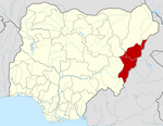
Song, Nigeria
Song | |
|---|---|
LGA and town | |
 Map of Adamawa State highlighting Song | |
| Coordinates: 9°49′28″N 12°37′30″E / 9.82444°N 12.62500°E | |
| Country | |
| State | Adamawa State |
| Time zone | UTC+1 (WAT) |
 | |
Song is a town and Local Government Area in Adamawa State, Nigeria is a town and also a local government area in the state with the area council consisting districts of Song, Dumme, Dirma, Kilange, Funa, Gudu, Mboi, Kilange, Hirna, Gari, Waje, Suktu, Zumo, Waltandi and Ditera.[1]
Population
[edit]The estimated population of Song is 260,900.[2]
Climate
[edit]In Song, the dry season is oppressively hot and partly cloudy, and the wet season is oppressively hot and overcast. Throughout the year, the average temperature ranges from 61 to 103 degrees Fahrenheit, rarely falling below 56 or rising over 108.[3]
Geography of Song
[edit]Song has an average temperature of 31°C. The LGA has some slopes with the region having a typical breeze speed of 11 km/h. The LGA likewise has a couple of streams and waterways moving through its domain.[4]
References
[edit]- ^ "Song Local Government Area". www.finelib.com. Retrieved 2022-05-14.
- ^ "Song (Local Government Area, Nigeria) - Population Statistics, Charts, Map and Location". www.citypopulation.de. Retrieved 2022-05-14.
- ^ "Song Climate, Weather By Month, Average Temperature (Nigeria) - Weather Spark". weatherspark.com. Retrieved 2023-08-06.
- ^ "Song Local Government Area". www.manpower.com.ng. Retrieved 2023-10-18.


