From Wikipedia, the free encyclopedia
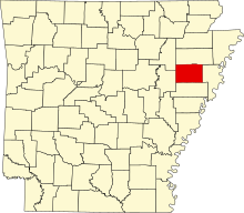
Location of Cross County in Arkansas This is a list of the National Register of Historic Places listings in Cross County, Arkansas .
This is intended to be a complete list of the properties and districts on the National Register of Historic Places in Cross County , Arkansas , United States . The locations of National Register properties and districts for which the latitude and longitude coordinates are included below, may be seen in a map.[ 1]
There are 19 properties and districts listed on the National Register in the county, including 1 National Historic Landmark . There are two formerly listed properties.
Contents: Counties in Arkansas
This National Park Service list is complete through NPS recent listings posted August 16, 2024. [ 2]
[ 3] Name on the Register[ 4]
Image
Date listed[ 5]
Location
City or town
Description
1
Isaac Block House Upload image July 15, 1998 (#98000851 ) 404 E. Hamilton St. 35°13′35″N 90°47′19″W / 35.226389°N 90.788611°W / 35.226389; -90.788611 (Isaac Block House ) Wynne
3
East Hamilton Avenue Historic District East Hamilton Avenue Historic District June 8, 2011 (#11000330 ) E. Hamilton Ave. between N. Falls Blvd. & N. Killough Rd.; Eldridge Ct. 35°13′31″N 90°48′51″W / 35.225278°N 90.814167°W / 35.225278; -90.814167 (East Hamilton Avenue Historic District ) Wynne
4
Giboney-Robertson-Stewart House Giboney-Robertson-Stewart House June 5, 1998 (#98000585 ) 734 Hamilton Ave. 35°13′32″N 90°47′05″W / 35.225556°N 90.784722°W / 35.225556; -90.784722 (Giboney-Robertson-Stewart House ) Wynne
5
Grace Episcopal Church Grace Episcopal Church March 5, 1992 (#92000106 ) 614 E. Poplar St. 35°13′40″N 90°47′12″W / 35.227778°N 90.786667°W / 35.227778; -90.786667 (Grace Episcopal Church ) Wynne
6
John H. Johnston Cotton Gin Historic District John H. Johnston Cotton Gin Historic District June 1, 2005 (#05000490 ) Junction of U.S. Route 64 and Highway 163 35°15′01″N 90°42′48″W / 35.250278°N 90.713333°W / 35.250278; -90.713333 (John H. Johnston Cotton Gin Historic District ) Levesque
7
Memphis to Little Rock Road-Strong's Ferry Segment Upload image May 15, 2012 (#12000274 ) Address Restricted Jennette vicinitypart of the Cherokee Trail of Tears Multiple Property Submission
8
Memphis to Little Rock Road-Village Creek Segment Memphis to Little Rock Road-Village Creek Segment April 11, 2003 (#03000193 ) East of Lake Austell within Village Creek State Park 35°08′48″N 90°43′00″W / 35.146667°N 90.716667°W / 35.146667; -90.716667 (Memphis to Little Rock Road-Village Creek Segment ) Newcastle A segment of the Trail of Tears
9
New Hope School New Hope School November 12, 2008 (#08001037 ) 3762 Highway 284 35°12′26″N 90°43′56″W / 35.207139°N 90.732144°W / 35.207139; -90.732144 (New Hope School ) Wynne
10
Northern Ohio School Northern Ohio School May 23, 2014 (#14000247 ) 60 Highway 84N 35°16′47″N 90°33′28″W / 35.2797°N 90.5578°W / 35.2797; -90.5578 (Northern Ohio School ) Parkin
11
Servetus W. Ogan House Servetus W. Ogan House September 28, 2015 (#15000624 ) 504 E. Forrest Ave. 35°13′42″N 90°47′15″W / 35.2283°N 90.7875°W / 35.2283; -90.7875 (Servetus W. Ogan House ) Wynne
12
Parkin Indian Mound Parkin Indian Mound October 15, 1966 (#66000200 ) Junction of U.S. Route 64 and Highway 184 [ 6] 35°16′38″N 90°33′27″W / 35.277139°N 90.557406°W / 35.277139; -90.557406 (Parkin Indian Mound ) Parkin
13
South Elementary School South Elementary School May 24, 2006 (#06000419 ) 711 E. Union Ave. 35°13′31″N 90°47′09″W / 35.225278°N 90.785833°W / 35.225278; -90.785833 (South Elementary School ) Wynne
14
Wittsburg Fortification Upload image December 31, 2002 (#02001626 ) Address Restricted Wittsburg
15
Wittsburg Store and Gas Station Upload image November 22, 2000 (#00001386 ) County Road 739 35°13′05″N 90°42′00″W / 35.218056°N 90.7°W / 35.218056; -90.7 (Wittsburg Store and Gas Station ) Wittsburg
16
Woman's Progressive Club Woman's Progressive Club March 27, 1990 (#90000430 ) Rowena St. and Merriman Ave. 35°13′25″N 90°47′21″W / 35.223611°N 90.789167°W / 35.223611; -90.789167 (Woman's Progressive Club ) Wynne
17
Wynne Commercial Historic District Wynne Commercial Historic District December 22, 2009 (#09001115 ) Roughly bounded by Front St., Commercial Ave., Terry St., Wilson St., and Pecan Ave. 35°13′23″N 90°47′30″W / 35.223172°N 90.791717°W / 35.223172; -90.791717 (Wynne Commercial Historic District ) Wynne
18
Wynne Post Office Wynne Post Office August 14, 1998 (#98000914 ) 402 E. Merriman Ave. 35°13′27″N 90°47′21″W / 35.224167°N 90.789167°W / 35.224167; -90.789167 (Wynne Post Office ) Wynne
19
Wynne Wholesale Commercial Historic District Wynne Wholesale Commercial Historic District January 25, 2010 (#09000772 ) Corner of W. Merriman and Martin Luther King Dr. 35°13′28″N 90°47′38″W / 35.224536°N 90.793917°W / 35.224536; -90.793917 (Wynne Wholesale Commercial Historic District ) Wynne
^ The latitude and longitude information provided in this table was derived originally from the National Register Information System, which has been found to be fairly accurate for about 99% of listings. Some locations in this table may have been corrected to current GPS standards.
^ National Park Service, United States Department of the Interior , "National Register of Historic Places: Weekly List Actions" , retrieved August 16, 2024.
^ a b Numbers represent an alphabetical ordering by significant words. Various colorings, defined here , differentiate National Historic Landmarks and historic districts from other NRHP buildings, structures, sites or objects.
^ "National Register Information System" . National Register of Historic Places National Park Service . March 13, 2009.^ The eight-digit number below each date is the number assigned to each location in the National Register Information System database, which can be viewed by clicking the number.
^ Location derived from this Parkin Archeological State Park webpage; the NRIS lists the site as "Address Restricted".
Topics Lists by state Lists by insular areas Lists by associated state Other areas Related


