Garzweiler surface mine
You can help expand this article with text translated from the corresponding article in German. (June 2017) Click [show] for important translation instructions.
|
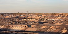
 Panoramic view of Tagebau Garzweiler | |
| Location | |
|---|---|
| Country | Germany |
| Coordinates | 51°03′15″N 6°30′35″E / 51.05417°N 6.50972°E |
| Production | |
| Products | Lignite |
| Owner | |
| Company | RWE |

The Tagebau Garzweiler (German pronunciation: [ˈtaːɡəbaʊ̯ ˈɡaʁt͜sˌʋaɪ̯lɐ]) is a surface mine (German: Tagebau) in the German state of North Rhine-Westphalia. It is operated by RWE and used for mining lignite.[1] The mine currently has a size of 48 km2 (19 sq mi) and got its name from the village of Garzweiler which previously existed at this location. The community was moved to a section of Jüchen with the same name.[2]
The open-pit mine
[edit]
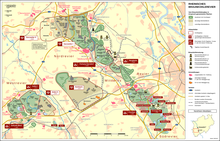
The mine is located west of Grevenbroich and exploitation is progressing towards Erkelenz. Mining was originally limited to the 66 km2 (25 sq mi) Garzweiler I area located east of the A 44 motorway. Mining in the 48 km2 (19 sq mi) Garzweiler II area started in 2006 and it will take until around 2045 to fully exploit both sectors. The lignite is used for power generation at nearby power plants such as Neurath[3] and Niederaußem. In 2015 1500 protesters took part in civil disobedience against the mine on the basis that it is Europe’s biggest source of CO2 emissions. Around 1000 people entered the coal mine and all of the diggers in its pit were brought to a standstill.[4]
It is not yet known what effect the plan to phase out all coal-fired power plants in Germany by 2038 will have on the Garzweiler lignite mine system.[5]
Traffic
[edit]The A 44 and A 61 motorways that crossed the planned mine area were also affected. The A 44 was closed in 2005, dismantled in 2006 and traffic rerouted to the widened A 61 and A 46 motorways. In 2017, as the mine expanded to the west, the A 61 was closed with traffic diverted onto a stretch of newly built A 44 to the east of its original route.
Displacement of people
[edit]In the early 1980s, it is estimated that more than 30,000 people had to be moved for the Garzweiler mine.[6] These people had to leave their houses and move. Plans for Garzweiler II required that 12 more towns would have to be removed, with around 12,000 more people relocated. This has caused many controversies where people protested to save their homes.
See also
[edit]- Church of St. Lambertus, Immerath
- Berverath
- Keyenberg
- Lützerath
- Kuckum
- Oberwestrich
- Unterwestrich
- North–South industrial spur
- Schloss Paffendorf
- Straße der Energie ("Street of energy")
- Ende Gelände 2015
- Ende Gelände 2019
- Inden open pit mine
- Hambach open pit mine
- Rhenish lignite mining area
- List of lignite mines in Germany
- List of active mines in Germany
- Commission on Growth, Structural Change and Employment
References
[edit]- ^ Barry, John (2002). International Encyclopedia of International Politics. Taylor & Francis. p. 216. ISBN 9780415202855. Retrieved 2013-05-26.
- ^ Rolf Sevenich: Garzweiler II. Kersting, Aachen 1996, ISBN 3-928047-12-4.
- ^ Hambachgruppe: Verheizte Heimat – Der Braunkohletagebau und seine Folgen. Aachen 1985, ISBN 3-924007-14-4 (PDF[permanent dead link])
- ^ 350.org (2023-09-06). "Organising Civil Disobedience for Newcomers". The Commons Social Change Library. Retrieved 2023-10-23.
{{cite web}}: CS1 maint: numeric names: authors list (link) - ^ Kirschbaum, Erik (January 26, 2019). "Germany to close all 84 of its coal-fired power plants, will rely primarily on renewable energy". Los Angeles Times. Archived from the original on 2019-01-30. Retrieved January 27, 2019.
Germany, one of the world's biggest consumers of coal, will shut down all 84 of its coal-fired power plants over the next 19 years to meet its international commitments in the fight against climate change, a government commission said Saturday.
- ^ Aben, T.T., Kroonen, K.J., Piket, J.J. & Puts, P.J.P. (2021) Make a little space for the human race. Retrieved 8 December 2021.


