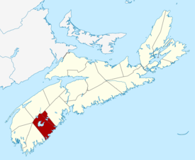
Region of Queens Municipality
Region of Queens Municipality | |
|---|---|
| Motto(s): Rivers, Forest, Sea | |
 Location of Region of Queens Municipality, Nova Scotia | |
| Coordinates: 44°02′N 64°43′W / 44.033°N 64.717°W | |
| Country | Canada |
| Province | Nova Scotia |
| Incorporated | April 1, 1996 |
| Electoral Districts Federal | South Shore—St. Margaret's |
| Provincial | Queens-Shelburne |
| Government | |
| • Type | Queens Regional Council |
| • Mayor | Darlene Norman |
| Area (2016)[1] | |
| • Land | 2,387.52 km2 (921.83 sq mi) |
| Population (2021)[1] | |
| • Total | 10,422 |
| • Density | 4.3/km2 (11/sq mi) |
| • Change 2011-2016 | |
| • Census ranking | 400 of 5,162 |
| Time zone | UTC-4 (AST) |
| • Summer (DST) | UTC-3 (ADT) |
| Area code(s) | 902, 782 |
| Dwellings | 6,150 |
| Median Income* | $36,461 CDN |
| Website | regionofqueens.com |
| |
The Region of Queens Municipality is a regional municipality in southwestern Nova Scotia, Canada. It is the northern gateway of the UNESCO Southwest Nova Biosphere Reserve, a centre of outdoor activities. Campgrounds at Kejimukujik National Park and National Historic Site, Thomas H. Raddall Provincial Park, and several other locations offer hiking, biking, canoeing, kayaking, cross-country skiing and snowshoeing. Its seacoast and inland areas are popular photo locations.
Geography
[edit]The municipality's boundary includes all of Queens County except for First Nations reserves.
The municipality is 2,760 km2 (1,070 sq mi), with a diverse geography. Some of its communities are on the Atlantic Ocean's shoreline, while others are further inland; these differences can lead to localized weather patterns. Overall, the municipality's proximity to the ocean provides a temperate climate with mild winters, comfortable summers and a long autumn season.
History
[edit]The Region of Queens Municipality was formed in 1996 through an amalgamation of the town of Liverpool and the Municipality of the County of Queens. Its other communities include:
- Beach Meadows
- Brooklyn
- Caledonia
- Greenfield
- Middlefield
- Mill Village
- Milton
- Northfield
- Port Joli
- Port Medway
- Port Mouton
- Western Head
Demographics
[edit]In the 2021 Census of Population conducted by Statistics Canada, the Region of Queens Municipality had a population of 10,422 living in 4,977 of its 6,676 total private dwellings, a change of 1.2% from its 2016 population of 10,302. With a land area of 2,387.52 km2 (921.83 sq mi), it had a population density of 4.4/km2 (11.3/sq mi) in 2021.[2]
|
|
| Ethnic Origin | Population | Pct (%) |
|---|---|---|
| Canadian | 5,245 | 47.6% |
| German | 3,110 | 28.2% |
| English | 3,005 | 27.3% |
| Scottish | 2,225 | 20.2% |
| Irish | 1,740 | 15.8% |
| French | 1,205 | 10.9% |
| Dutch (Netherlands) | 910 | 8.3% |
| North American Indian | 840 | 7.6% |
Access routes
[edit]Highways and numbered routes that run through the municipality, including external routes that start or finish at the municipal boundary:[6]
|
|
See also
[edit]References
[edit]- ^ a b "Population and dwelling counts, for Canada, provinces and territories, and census subdivisions (municipalities), 2016 and 2011 censuses – 100% data (Nova Scotia)". Statistics Canada. February 8, 2017. Retrieved February 12, 2017.
- ^ "Population and dwelling counts: Canada, provinces and territories, census divisions and census subdivisions (municipalities), Nova Scotia". Statistics Canada. February 9, 2022. Retrieved March 12, 2022.
- ^ Statistics Canada: 1996, 2001, 2006 census
- ^ Statistics Canada: 2011 census
- ^ 2006 Statistics Canada Census Ethnocultural Portrait of Canada: Queens Regional Municipality, Nova Scotia
- ^ Atlantic Canada Back Road Atlas ISBN 978-1-55368-618-7 Pages 86-87, 90

