Griesheim (Frankfurt am Main)
This article needs additional citations for verification. (September 2021) |
Griesheim | |
|---|---|
 | |
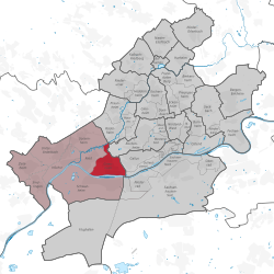
Location of Griesheim (red) and the Ortsbezirk West (light red) within Frankfurt am Main | |
| Coordinates: 50°05′32″N 08°36′25″E / 50.09222°N 8.60694°E | |
| Country | Germany |
| State | Hesse |
| Admin. region | Darmstadt |
| District | Urban district |
| City | Frankfurt am Main |
| Area | |
| • Total | 4.200 km2 (1.622 sq mi) |
| Population (2020-12-31)[1] | |
| • Total | 23,569 |
| • Density | 5,600/km2 (15,000/sq mi) |
| Time zone | UTC+01:00 (CET) |
| • Summer (DST) | UTC+02:00 (CEST) |
| Postal codes | 65933 |
| Dialling codes | 069 |
| Vehicle registration | F |
| Website | www.frankfurt.de |
Griesheim (German pronunciation: [ˈɡʁiːsˌhaɪ̯m] ) is a quarter of Frankfurt am Main, Germany. It is part of the Ortsbezirk West.
Griesheim had been an independent town until 1928, the year of its suburbanisation. It is located between Nied, Sossenheim, Bockenheim, Gallus and Schwanheim.
References
[edit]- ^ "Frankfurt Statsitik Aktuell 07/2021". Stadt Frankfurt am Main. July 2021. Archived from the original on 2021-08-01. Retrieved 2021-09-22.
External links
[edit]![]() Media related to Frankfurt-Griesheim at Wikimedia Commons
Media related to Frankfurt-Griesheim at Wikimedia Commons


