Pico de Orizaba (Citlaltépetl ), a stratovolcano on the boundary between the states of Puebla and Veracruz , is the highest mountain peak of Mexico .This article comprises three sortable tables of major mountain peaks [1] Mexico .
The summit of a mountain or hill may be measured in three principal ways:
The topographic elevation of a summit measures the height on the summit above a geodetic sea level .[2] first table below ranks the 40 highest major summits of México by elevation. The topographic prominence of a summit is a measure of how high the summit rises above its surroundings.[3] [2] second table below ranks the 40 most prominent summits of México. The topographic isolation (or radius of dominance) of a summit measures how far the summit lies from its nearest point of equal elevation.[4] third table below ranks the 40 most isolated major summits of México.
Highest major summits [ edit ] Of the 40 highest major summits of Mexico, three peaks exceed 5000 meters (16,404 feet) elevation, ten peaks exceed 4000 meters (13,123 feet), and 38 peaks exceed 3000 meters (9843 feet) elevation.
Of these 40 peaks, five are located in Jalisco, five in Coahuila, four in Oaxaca, six in Puebla, four in the state of Mexico, three in Chiapas, two in Nuevo León, two in Veracruz, two in Michoacán, two in Querétaro, two in Durango, two in Chihuahua, two in San Luis Potosí, and one each in Morelos, Tlaxcala, Mexico City, Colima, Guerrero, Guanajuato, Zacatecas, Baja California, Aguascalientes, Sinaloa, and Sonora. Volcán Tacaná lies on the international border between Chiapas and Guatemala, and nine other peaks lie on a state border.
The 40 highest summits of Mexico with at least 500 meters of topographic prominence 1 Pico de Orizaba [5] [6] [a] Citlaltépetl )Puebla Veracruz Trans-Mexican Volcanic Belt 19°01′50″N 97°16′11″W / 19.0305°N 97.2698°W / 19.0305; -97.2698 (Pico de Orizaba ) 2 Volcán Popocatépetl [7] [8] [b] [c] México Morelos Puebla Trans-Mexican Volcanic Belt 19°01′21″N 98°37′41″W / 19.0225°N 98.6280°W / 19.0225; -98.6280 (Volcán Popocatépetl ) 3 Iztaccíhuatl [9] [10] [d] México Puebla Trans-Mexican Volcanic Belt 19°10′48″N 98°38′30″W / 19.1801°N 98.6416°W / 19.1801; -98.6416 (Volcán Iztaccíhuatl ) 4 Nevado de Toluca [11] [12] [e] Xinantécatl )México Trans-Mexican Volcanic Belt 19°06′07″N 99°46′04″W / 19.1020°N 99.7677°W / 19.1020; -99.7677 (Nevado de Toluca ) 5 Sierra Negra [13] [f] Tliltépetl )Puebla Trans-Mexican Volcanic Belt 18°59′09″N 97°18′50″W / 18.9859°N 97.3140°W / 18.9859; -97.3140 (Sierra Negra ) 6 Volcán La Malinche [14] [15] [g] [h] Matlalcuéyetl )Puebla Tlaxcala Trans-Mexican Volcanic Belt 19°13′52″N 98°01′55″W / 19.2310°N 98.0320°W / 19.2310; -98.0320 (Volcán La Malinche ) 7 Cofre de Perote [16] [17] [i] Naucampatépetl )Veracruz Trans-Mexican Volcanic Belt 19°29′38″N 97°08′53″W / 19.4940°N 97.1480°W / 19.4940; -97.1480 (Cofre de Perote ) 8 Nevado de Colima [18] [19] [j] [k] Tzapotépetl )Jalisco Trans-Mexican Volcanic Belt 19°33′48″N 103°36′31″W / 19.5633°N 103.6087°W / 19.5633; -103.6087 (Nevado de Colima ) 9 Cerro Tláloc [20] [21] [l] México Trans-Mexican Volcanic Belt 19°24′45″N 98°42′45″W / 19.4125°N 98.7124°W / 19.4125; -98.7124 (Cerro Tláloc ) 10 Volcán Tacaná [22] [23] [m] Chiapas Guatemala Sierra Madre de Chiapas 15°07′57″N 92°06′31″W / 15.1325°N 92.1085°W / 15.1325; -92.1085 (Volcán Tacaná ) 11 Cerro Ajusco [24] [25] [n] Mexico City Trans-Mexican Volcanic Belt 19°12′27″N 99°15′30″W / 19.2074°N 99.2582°W / 19.2074; -99.2582 (Cerro Ajusco ) 12 Jocotitlán (volcano) [26] [27] México (state) Trans-Mexican Volcanic Belt 19°44′17″N 99°45′32″W / 19.738056°N 99.758889°W / 19.738056; -99.758889 (Jocotitlán ) 13 Volcán Tancítaro [28] [29] [o] Michoacán Trans-Mexican Volcanic Belt 19°25′00″N 102°19′11″W / 19.4166°N 102.3198°W / 19.4166; -102.3198 (Volcán Tancítaro ) 14 Volcán de Colima [30] [31] [p] Colima Jalisco Trans-Mexican Volcanic Belt 19°30′48″N 103°37′03″W / 19.5132°N 103.6174°W / 19.5132; -103.6174 (Volcán de Colima ) 15 Cerro El Potosí [32] [33] [q] Nuevo León Sierra Madre Oriental 24°52′19″N 100°13′58″W / 24.8719°N 100.2327°W / 24.8719; -100.2327 (Cerro el Potosí ) 16 Cerro San Rafael [34] [35] [r] [s] Coahuila Sierra Madre Oriental 25°21′49″N 100°33′26″W / 25.3637°N 100.5571°W / 25.3637; -100.5571 (Cerro San Rafael ) 17 Cerro el Nacimiento [36] [37] [t] Oaxaca Sierra Madre del Sur 16°12′41″N 96°11′48″W / 16.2115°N 96.1967°W / 16.2115; -96.1967 (Cerro el Nacimiento ) 18 Cerro El Campanario [u] Michoacán Trans-Mexican Volcanic Belt 19°35′43″N 100°14′50″W / 19.595297°N 100.247212°W / 19.595297; -100.247212 (Cerro El Campanario ) 19 Cerro Pelón massif high point México (state) Trans-Mexican Volcanic Belt 19°24′08″N 100°13′32″W / 19.402250°N 100.225493°W / 19.402250; -100.225493 (Cerro El Pelón massif high point ) 20 Cerro Teotepec [38] [v] Guerrero Sierra Madre del Sur 17°28′06″N 100°08′11″W / 17.4682°N 100.1364°W / 17.4682; -100.1364 (Cerro Teotepec ) Picacho San Onofre [39] Sierra Peña Nevada )Nuevo León Sierra Madre Oriental 23°48′03″N 99°50′47″W / 23.8007°N 99.8464°W / 23.8007; -99.8464 (Picacho San Onofre ) 22 Las Derrumbadas south summit Puebla Trans-Mexican Volcanic Belt 19°15′53″N 97°26′50″W / 19.264808°N 97.447356°W / 19.264808; -97.447356 (Las Derrumbadas ) 23 Cerro El Jabalín [40] [41] [w] Coahuila Mexican Plateau 25°11′24″N 101°22′39″W / 25.1899°N 101.3775°W / 25.1899; -101.3775 (Cerro El Jabalín ) 24 Cerro El Rosario [42] [x] Puebla Trans-Mexican Volcanic Belt 19°40′44″N 98°12′06″W / 19.678789°N 98.201574°W / 19.678789; -98.201574 (Cerro El Rosario ) 25 Cerro Zempoaltépetl [43] Oaxaca Sierra Madre de Oaxaca 17°07′57″N 96°00′45″W / 17.1324°N 96.0125°W / 17.1324; -96.0125 (Cerro Zempoaltépetl ) Las Derrumbadas north summit Puebla Trans-Mexican Volcanic Belt 19°18′06″N 97°28′14″W / 19.301626°N 97.470537°W / 19.301626; -97.470537 (Las Derrumbadas ) 27 El Zamorano [44] [45] [y] Querétaro Guanajuato Mexican Plateau 20°56′02″N 100°10′50″W / 20.9338°N 100.1805°W / 20.9338; -100.1805 (El Zamorano ) 28 Cerro la Muralla [46] Oaxaca Sierra Madre del Sur 17°08′04″N 97°39′50″W / 17.1344°N 97.6640°W / 17.1344; -97.6640 (Cerro la Muralla ) 29 Cerro Gordo [47] [48] [z] [aa] Durango Sierra Madre Occidental 23°12′22″N 104°56′39″W / 23.2060°N 104.9442°W / 23.2060; -104.9442 (Cerro Gordo ) 30 Cerro Mohinora [49] [50] [ab] [ac] Chihuahua Sierra Madre Occidental 25°57′22″N 107°02′51″W / 25.9560°N 107.0476°W / 25.9560; -107.0476 (Cerro Mohinora ) 31 El Pinal Puebla Trans-Mexican Volcanic Belt 19°08′32″N 97°54′25″W / 19.142227°N 97.906845°W / 19.142227; -97.906845 (El Pinal ) 32 Cerro El Refugio [51] [ad] Zacatecas Coahuila Mexican Plateau 24°34′34″N 101°06′17″W / 24.5761°N 101.1047°W / 24.5761; -101.1047 (Cerro El Refugio ) 33 Cerro Grande [52] [ae] San Luis Potosí Mexican Plateau 23°40′00″N 100°53′14″W / 23.6667°N 100.8873°W / 23.6667; -100.8873 (Cerro Grande ) 34 Cerro El Centinela [53] Coahuila Mexican Plateau 25°08′09″N 103°13′49″W / 25.1359°N 103.2304°W / 25.1359; -103.2304 (El Centinela (Baja California, Mexico) ) 35 Picacho del Diablo [54] [55] [af] [ag] Baja California Sierra de San Pedro Mártir 30°59′33″N 115°22′31″W / 30.9925°N 115.3753°W / 30.9925; -115.3753 (Picacho del Diablo ) 36 Sierra la Madera [56] Coahuila Mexican Plateau 27°02′04″N 102°23′32″W / 27.0345°N 102.3922°W / 27.0345; -102.3922 (Sierra la Madera ) 37 Sierra Fría [57] [ah] Aguascalientes Sierra Madre Occidental 22°16′26″N 102°36′26″W / 22.2739°N 102.6073°W / 22.2739; -102.6073 (Sierra Fría ) 38 Cerro Pinto Puebla Trans-Mexican Volcanic Belt 19°22′19″N 97°29′57″W / 19.371839°N 97.499266°W / 19.371839; -97.499266 (Cerro Pinto ) 39 Cerro Viejo [58] [59] Jalisco Mexican West Coast Ranges 20°21′53″N 103°26′12″W / 20.3648°N 103.4368°W / 20.3648; -103.4368 (Cerro Viejo ) 40 Cerro Alto Tapanco [60] [61] [ai] Sinaloa Durango Sierra Madre Occidental 25°37′14″N 106°57′59″W / 25.6206°N 106.9665°W / 25.6206; -106.9665 (Cerro Alto Tapanco )
Most prominent summits [ edit ] Of the 40 most prominent summits of México, only Pico de Orizaba exceeds 4000 meters (13,123 feet) of topographic prominence, Popocatépetl exceeds 3000 meters (9843 feet), five peaks exceed 2000 meters (6562 feet), and 26 peaks are ultra-prominent summits with at least 1500 meters (4921 feet) of topographic prominence .
Of these 40 peaks, five are located in Oaxaca, five in Baja California, four in Puebla, four in Jalisco, four in Nuevo León, four in Coahuila, three in Veracruz, three in México, three in Baja California Sur, two in Michoacán, two in Querétaro, and one each in Morelos, Guerrero, Tlaxcala, Guanajuato, Durango, Chiapas, and Distrito Federal. Five peaks lie on a state border.
The 40 most topographically prominent summits of México 1 Pico de Orizaba [5] [6] [a] Citlaltépetl )Puebla Veracruz Trans-Mexican Volcanic Belt 19°01′50″N 97°16′11″W / 19.0305°N 97.2698°W / 19.0305; -97.2698 (Pico de Orizaba ) 2 Volcán Popocatépetl [7] [8] [b] [c] México Morelos Puebla Trans-Mexican Volcanic Belt 19°01′21″N 98°37′41″W / 19.0225°N 98.6280°W / 19.0225; -98.6280 (Volcán Popocatépetl ) 3 Nevado de Colima [18] [19] [j] [k] Tzapotépetl )Jalisco Trans-Mexican Volcanic Belt 19°33′48″N 103°36′31″W / 19.5633°N 103.6087°W / 19.5633; -103.6087 (Nevado de Colima ) 4 Nevado de Toluca [11] [12] [e] Xinantécatl )México Trans-Mexican Volcanic Belt 19°06′07″N 99°46′04″W / 19.1020°N 99.7677°W / 19.1020; -99.7677 (Nevado de Toluca ) 5 Cerro Teotepec [38] [v] Guerrero Sierra Madre del Sur 17°28′06″N 100°08′11″W / 17.4682°N 100.1364°W / 17.4682; -100.1364 (Cerro Teotepec ) 6 Cerro el Nacimiento [36] [37] [t] Oaxaca Sierra Madre del Sur 16°12′41″N 96°11′48″W / 16.2115°N 96.1967°W / 16.2115; -96.1967 (Cerro el Nacimiento ) 7 Picacho del Diablo [54] [55] [af] [ag] Baja California Sierra de San Pedro Mártir 30°59′33″N 115°22′31″W / 30.9925°N 115.3753°W / 30.9925; -115.3753 (Picacho del Diablo ) 8 Sierra de Minas Viejas [62] Nuevo León Sierra Madre Oriental 26°07′11″N 100°33′24″W / 26.1196°N 100.5568°W / 26.1196; -100.5568 (Cerro Tia Chena ) 9 Cerro Las Conchas [63] [64] Michoacán Michoacán 18°43′17″N 102°58′26″W / 18.7215°N 102.9740°W / 18.7215; -102.9740 (Cerro Las Conchas ) 10 Volcán La Malinche [14] [15] [g] [h] Matlalcuéyetl )Puebla Tlaxcala Trans-Mexican Volcanic Belt 19°13′52″N 98°01′55″W / 19.2310°N 98.0320°W / 19.2310; -98.0320 (Volcán La Malinche ) 11 Pico La Laguna [65] [66] [aj] Baja California Sur Sierra La Laguna 23°32′21″N 109°57′15″W / 23.5392°N 109.9542°W / 23.5392; -109.9542 (Pico La Laguna ) 12 Sierra la Madera [56] Coahuila Mexican Plateau 27°02′04″N 102°23′32″W / 27.0345°N 102.3922°W / 27.0345; -102.3922 (Sierra la Madera ) 13 Cerro la Joya [67] Querétaro Sierra Madre Oriental 21°25′51″N 99°07′57″W / 21.4309°N 99.1326°W / 21.4309; -99.1326 (Cerro la Joya ) 14 Cerro El Potosí [68] [69] [ak] Nuevo León Sierra Madre Oriental 24°52′19″N 100°13′58″W / 24.8719°N 100.2327°W / 24.8719; -100.2327 (Cerro el Potosí ) 15 Volcán Tancítaro [28] [29] [o] Michoacán Trans-Mexican Volcanic Belt 19°25′00″N 102°19′11″W / 19.4166°N 102.3198°W / 19.4166; -102.3198 (Volcán Tancítaro ) 16 Cerro El Centinela [53] Coahuila Mexican Plateau 25°08′09″N 103°13′49″W / 25.1359°N 103.2304°W / 25.1359; -103.2304 (Cerro El Centinela ) 17 Picacho San Onofre [39] Sierra Peña Nevada )Nuevo León Sierra Madre Oriental 23°48′03″N 99°50′47″W / 23.8007°N 99.8464°W / 23.8007; -99.8464 (Picacho San Onofre ) El Aguacate Oeste [70] Oaxaca Sierra Madre del Sur 16°34′52″N 95°48′13″W / 16.5812°N 95.8035°W / 16.5812; -95.8035 (El Aguacate Oeste ) 19 Volcán Las Tres Vírgenes [71] Baja California Sur Tres Vírgenes 27°28′12″N 112°35′31″W / 27.4700°N 112.5919°W / 27.4700; -112.5919 (Volcán Las Tres Vírgenes ) 20 Sierra de Santa Martha [72] Veracruz Trans-Mexican Volcanic Belt 18°20′44″N 94°51′27″W / 18.3455°N 94.8576°W / 18.3455; -94.8576 (Sierra de Santa Martha ) 21 Cerro las Capillas [73] Jalisco Jalisco 19°33′19″N 104°08′50″W / 19.5552°N 104.1472°W / 19.5552; -104.1472 (Cerro las Capillas ) 22 Cerro Zempoaltépetl [43] Oaxaca Sierra Madre del Sur 17°07′57″N 96°00′45″W / 17.1324°N 96.0125°W / 17.1324; -96.0125 (Cerro Zempoaltépetl ) 23 Iztaccíhuatl [9] [10] [d] México Puebla Trans-Mexican Volcanic Belt 19°10′48″N 98°38′30″W / 19.1801°N 98.6416°W / 19.1801; -98.6416 (Volcán Iztaccíhuatl ) Volcán de Tequila [74] [75] Jalisco Jalisco 20°47′14″N 103°50′48″W / 20.7872°N 103.8468°W / 20.7872; -103.8468 (Volcán de Tequila ) 25 Cerro Atravesado [76] Sierra el Cerro Azul )Oaxaca Oaxaca 16°45′55″N 94°27′05″W / 16.7652°N 94.4514°W / 16.7652; -94.4514 (Cerro Atravesado ) Sierra del Fraile [77] Nuevo León Sierra Madre Oriental 25°51′52″N 100°36′34″W / 25.8645°N 100.6095°W / 25.8645; -100.6095 (Picachos el Fraile ) 27 Cerro El Zamorano [78] [79] [al] Querétaro Guanajuato Mexican Plateau 20°56′02″N 100°10′50″W / 20.9338°N 100.1805°W / 20.9338; -100.1805 (Cerro El Zamorano ) 28 Cerro la Muralla [46] Oaxaca Sierra Madre del Sur 17°08′04″N 97°39′50″W / 17.1344°N 97.6640°W / 17.1344; -97.6640 (Cerro la Muralla ) 29 Cofre de Perote [16] [17] [i] Naucampatépetl )Veracruz Trans-Mexican Volcanic Belt 19°29′38″N 97°08′53″W / 19.4940°N 97.1480°W / 19.4940; -97.1480 (Cofre de Perote ) 30 Cerro San Rafael [34] [35] [r] [s] Coahuila Sierra Madre Oriental 25°21′49″N 100°33′26″W / 25.3637°N 100.5571°W / 25.3637; -100.5571 (Cerro San Rafael ) 31 Cerro La Sandía [80] Baja California Baja California Peninsula 28°24′26″N 113°26′19″W / 28.4073°N 113.4387°W / 28.4073; -113.4387 (Cerro La Sandía ) Cerro Giganta [81] [am] Baja California Sur Sierra de la Giganta 26°06′23″N 111°35′04″W / 26.1064°N 111.5844°W / 26.1064; -111.5844 (Cerro Giganta ) 33 Cerro Gordo [47] [48] [z] [aa] Durango Sierra Madre Occidental 23°12′22″N 104°56′39″W / 23.2060°N 104.9442°W / 23.2060; -104.9442 (Cerro Gordo ) 34 Cerro Tzontehuitz [82] Chiapas Sierra Madre de Chiapas 16°50′09″N 92°35′22″W / 16.8358°N 92.5894°W / 16.8358; -92.5894 (Cerro Tzontehuitz ) 35 Cerro Viejo [58] [59] Jalisco Mexican West Coast Ranges 20°21′53″N 103°26′12″W / 20.3648°N 103.4368°W / 20.3648; -103.4368 (Cerro Viejo ) 36 Cerro El Jabalín [40] [41] [w] Coahuila Mexican Plateau 25°11′24″N 101°22′39″W / 25.1899°N 101.3775°W / 25.1899; -101.3775 (Cerro El Jabalín ) 37 Isla Guadalupe high point [83] [an] Baja California Isla Guadalupe 29°06′06″N 118°18′48″W / 29.1016°N 118.3132°W / 29.1016; -118.3132 (Isla Guadalupe high point ) 38 Cerro Las Palmas [84] [ao] Baja California Sur Sierra de la Giganta 26°51′40″N 112°27′27″W / 26.8612°N 112.4574°W / 26.8612; -112.4574 (Cerro Las Palmas ) 39 Cerro Ajusco [24] [25] [n] Distrito Federal Trans-Mexican Volcanic Belt 19°12′27″N 99°15′30″W / 19.2074°N 99.2582°W / 19.2074; -99.2582 (Cerro Ajusco ) 40 Isla Cedros high point [85] Baja California Isla Cedros 28°07′48″N 115°13′14″W / 28.1301°N 115.2206°W / 28.1301; -115.2206 (Isla Cedros high point )
Most isolated major summits [ edit ] Of the 40 most isolated major summits of México, only Pico de Orizaba exceeds 2000 kilometers (1243 miles) of topographic isolation. Four peaks exceed 500 kilometers (310.7 miles), 14 peaks exceed 200 kilometers (124.3 miles), and 33 peaks exceed 100 kilometers (62.14 miles) of topographic isolation.
Of these 40 peaks, five are located in Coahuila, four in Baja California, four in Oaxaca, three in Puebla, three in Jalisco, three in Baja California Sur, two in Veracruz, two in Nuevo León, two in Chihuahua, two in Chiapas, two in México, two in Michoacán, two in Querétaro, and one each in Colima, Durango, Guerrero, Sonora, Morelos, Guanajuato, San Luis Potosí, Zacatecas, Tlaxcala, and Nayarit. Six peaks lie on a state border.
The 40 most topographically isolated summits of México with at least 500 meters of topographic prominence 1 Pico de Orizaba [5] [6] [a] Citlaltépetl )Puebla Veracruz Trans-Mexican Volcanic Belt 19°01′50″N 97°16′11″W / 19.0305°N 97.2698°W / 19.0305; -97.2698 (Pico de Orizaba ) 2 Cerro San Rafael [34] [35] [r] [s] Coahuila Sierra Madre Oriental 25°21′49″N 100°33′26″W / 25.3637°N 100.5571°W / 25.3637; -100.5571 (Cerro San Rafael ) 3 Cerro El Potosí [68] [69] [ak] Nuevo León Sierra Madre Oriental 24°52′19″N 100°13′58″W / 24.8719°N 100.2327°W / 24.8719; -100.2327 (Cerro el Potosí ) 4 Volcán Everman [86] [ap] Colima Isla Socorro 18°48′00″N 110°59′00″W / 18.8000°N 110.9833°W / 18.8000; -110.9833 (Volcán Everman ) 5 Cerro Gordo [47] [48] [z] [aa] Durango Sierra Madre Occidental 23°12′22″N 104°56′39″W / 23.2060°N 104.9442°W / 23.2060; -104.9442 (Cerro Gordo ) 6 Nevado de Colima [18] [19] [j] [k] Tzapotépetl )Jalisco Trans-Mexican Volcanic Belt 19°33′48″N 103°36′31″W / 19.5633°N 103.6087°W / 19.5633; -103.6087 (Nevado de Colima ) 7 Pico La Laguna [65] [66] [aj] Baja California Sur Sierra La Laguna 23°32′21″N 109°57′15″W / 23.5392°N 109.9542°W / 23.5392; -109.9542 (Pico La Laguna ) 8 Volcán Las Tres Vírgenes [87] Baja California Sur Tres Virgenes 27°28′12″N 112°35′31″W / 27.4700°N 112.5919°W / 27.4700; -112.5919 (Volcán Las Tres Vírgenes ) 9 Isla Guadalupe high point [83] [an] Baja California Isla Guadalupe 29°06′06″N 118°18′48″W / 29.1016°N 118.3132°W / 29.1016; -118.3132 (Isla Guadalupe high point ) 10 Picacho del Diablo [54] [55] [af] [ag] Baja California Sierra de San Pedro Mártir 30°59′33″N 115°22′31″W / 30.9925°N 115.3753°W / 30.9925; -115.3753 (Picacho del Diablo ) 11 Cerro el Nacimiento [36] [37] [t] Oaxaca Sierra Madre del Sur 16°12′41″N 96°11′48″W / 16.2115°N 96.1967°W / 16.2115; -96.1967 (Cerro el Nacimiento ) 12 Sierra Fría [57] [ah] Aguascalientes Sierra Madre Occidental 22°16′26″N 102°36′26″W / 22.2739°N 102.6073°W / 22.2739; -102.6073 (Sierra Fría ) 13 Cerro Mohinora [49] [50] [ab] [ac] Chihuahua Sierra Madre Occidental 25°57′22″N 107°02′51″W / 25.9560°N 107.0476°W / 25.9560; -107.0476 (Cerro Mohinora ) 14 Sierra la Madera [56] Coahuila Mexican Plateau 27°02′04″N 102°23′32″W / 27.0345°N 102.3922°W / 27.0345; -102.3922 (Sierra la Madera ) 15 Cerro El Centinela [53] Coahuila Mexican Plateau 25°08′09″N 103°13′49″W / 25.1359°N 103.2304°W / 25.1359; -103.2304 (Cerro El Centinela ) 16 Cerro Teotepec [38] [v] Guerrero Sierra Madre del Sur 17°28′06″N 100°08′11″W / 17.4682°N 100.1364°W / 17.4682; -100.1364 (Cerro Teotepec ) 17 Sierra de Santa Martha [72] Veracruz Trans-Mexican Volcanic Belt 18°20′44″N 94°51′27″W / 18.3455°N 94.8576°W / 18.3455; -94.8576 (Sierra de Santa Martha ) 18 Cerro la Muralla [46] Oaxaca Sierra Madre del Sur 17°08′04″N 97°39′50″W / 17.1344°N 97.6640°W / 17.1344; -97.6640 (Cerro la Muralla ) 19 Isla Cedros high point [85] Baja California Isla Cedros 28°07′48″N 115°13′14″W / 28.1301°N 115.2206°W / 28.1301; -115.2206 (Isla Cedros high point ) 20 Cerro Tzontehuitz [82] Chiapas Sierra Madre de Chiapas 16°50′09″N 92°35′22″W / 16.8358°N 92.5894°W / 16.8358; -92.5894 (Cerro Tzontehuitz ) 21 Cerro San José [88] [89] [aq] Chihuahua Sonora Mexican Plateau 30°32′54″N 108°37′00″W / 30.5483°N 108.6167°W / 30.5483; -108.6167 (Cerro San José ) 22 Volcán Popocatépetl [7] [8] [b] [c] México Morelos Puebla Trans-Mexican Volcanic Belt 19°01′21″N 98°37′41″W / 19.0225°N 98.6280°W / 19.0225; -98.6280 (Volcán Popocatépetl ) 23 Volcán Tancítaro [28] [29] [o] Michoacán Trans-Mexican Volcanic Belt 19°25′00″N 102°19′11″W / 19.4166°N 102.3198°W / 19.4166; -102.3198 (Volcán Tancítaro ) 24 Cerro La Sandía [80] Baja California Baja California Peninsula 28°24′26″N 113°26′19″W / 28.4073°N 113.4387°W / 28.4073; -113.4387 (Cerro La Sandía ) 25 Cerro Tres Picos [90] Chiapas Sierra Madre de Chiapas 16°11′49″N 93°36′40″W / 16.1970°N 93.6112°W / 16.1970; -93.6112 (Cerro Tres Picos ) 26 Picacho San Onofre [39] Sierra Peña Nevada )Nuevo León Sierra Madre Oriental 23°48′03″N 99°50′47″W / 23.8007°N 99.8464°W / 23.8007; -99.8464 (Picacho San Onofre ) 27 Cerro Giganta [81] [am] Baja California Sur Sierra de la Giganta 26°06′23″N 111°35′04″W / 26.1064°N 111.5844°W / 26.1064; -111.5844 (Cerro Giganta ) 28 Nevado de Toluca [11] [12] [e] Xinantécatl )México Trans-Mexican Volcanic Belt 19°06′07″N 99°46′04″W / 19.1020°N 99.7677°W / 19.1020; -99.7677 (Nevado de Toluca ) 29 Cerro Atravesado [76] Sierra el Cerro Azul )Oaxaca Oaxaca 16°45′55″N 94°27′05″W / 16.7652°N 94.4514°W / 16.7652; -94.4514 (Cerro Atravesado ) 30 Cerro El Zamorano [78] [79] [al] Querétaro Guanajuato Mexican Plateau 20°56′02″N 100°10′50″W / 20.9338°N 100.1805°W / 20.9338; -100.1805 (Cerro El Zamorano ) 31 Cerro Las Conchas [63] [64] Michoacán Michoacán 18°43′17″N 102°58′26″W / 18.7215°N 102.9740°W / 18.7215; -102.9740 (Cerro Las Conchas ) 32 Cerro Zempoaltépetl [43] Oaxaca Sierra Madre del Sur 17°07′57″N 96°00′45″W / 17.1324°N 96.0125°W / 17.1324; -96.0125 (Cerro Zempoaltépetl ) 33 Cerro Grande [52] [ae] San Luis Potosí Mexican Plateau 23°40′00″N 100°53′14″W / 23.6667°N 100.8873°W / 23.6667; -100.8873 (Cerro Grande ) 34 Cerro Viejo [58] [59] Jalisco Mexican West Coast Ranges 20°21′53″N 103°26′12″W / 20.3648°N 103.4368°W / 20.3648; -103.4368 (Cerro Viejo ) 35 Cerro El Jabalín [40] [41] [w] Coahuila Mexican Plateau 25°11′24″N 101°22′39″W / 25.1899°N 101.3775°W / 25.1899; -101.3775 (Cerro El Jabalín ) 36 Cerro El Refugio [51] [ad] Zacatecas Coahuila Mexican Plateau 24°34′34″N 101°06′17″W / 24.5761°N 101.1047°W / 24.5761; -101.1047 (Cerro El Refugio ) 37 Cerro Las Palmas [84] [ao] Baja California Sur Sierra de la Giganta 26°51′40″N 112°27′27″W / 26.8612°N 112.4574°W / 26.8612; -112.4574 (Cerro Las Palmas ) 38 Cerro la Joya [67] Querétaro Sierra Madre Oriental 21°25′51″N 99°07′57″W / 21.4309°N 99.1326°W / 21.4309; -99.1326 (Cerro la Joya ) 39 Volcán de Tequila [74] [75] Jalisco Jalisco 20°47′14″N 103°50′48″W / 20.7872°N 103.8468°W / 20.7872; -103.8468 (Volcán de Tequila ) 40 Volcán La Malinche [14] [15] [g] [h] Matlalcuéyetl )Puebla Tlaxcala Trans-Mexican Volcanic Belt 19°13′52″N 98°01′55″W / 19.2310°N 98.0320°W / 19.2310; -98.0320 (Volcán La Malinche )
^ This article defines a significant summit as a summit with at least 100 meters (328.1 feet) of topographic prominence , and a major summit as a summit with at least 500 meters (1640 feet) on topographic prominence. All summits in this article have at least 500 meters of topographic prominence. An ultra-prominent summit is a summit with at least 1500 meters (4921 feet) of topographic prominence. ^ Jump up to: a b If the elevation or prominence of a summit is calculated as a range of values, the arithmetic mean is shown. ^ The topographic prominence of a summit is the topographic elevation difference between the summit and its highest or key col to a higher summit . The summit may be near its key col or quite far away. The key col for Denali in Alaska is the Isthmus of Rivas in Nicaragua , 7642 kilometers (4749 miles) away. ^ The topographic isolation of a summit is the great-circle distance to its nearest point of equal elevation. ^ Jump up to: a b c "Pico de Orizaba" . Peakbagger.com . Retrieved December 12, 2023 .^ Jump up to: a b c "Pico de Orizaba" . Bivouac.com . Retrieved December 12, 2023 .^ Jump up to: a b c "Volcán Popocatépetl" . Peakbagger.com . Retrieved December 12, 2023 .^ Jump up to: a b c "Volcán Popocatépetl" . Bivouac.com . Retrieved December 12, 2023 .^ Jump up to: a b "Iztaccíhuatl" . Peakbagger.com . Retrieved December 12, 2023 .^ Jump up to: a b "Iztaccíhuatl" . Bivouac.com . Retrieved December 12, 2023 .^ Jump up to: a b c "Nevado de Toluca" . Peakbagger.com . Retrieved December 12, 2023 .^ Jump up to: a b c "Nevado de Toluca" . Bivouac.com . Retrieved December 12, 2023 .^ "Sierra Negra" . Peakbagger.com . Retrieved December 12, 2023 .^ Jump up to: a b c "Volcán La Malinche" . Peakbagger.com . Retrieved December 12, 2023 .^ Jump up to: a b c "Volcán La Malinche" . Bivouac.com . Retrieved December 12, 2023 .^ Jump up to: a b "Cofre de Perote" . Peakbagger.com . Retrieved December 12, 2023 .^ Jump up to: a b "Cofre de Perote" . Bivouac.com . Retrieved December 12, 2023 .^ Jump up to: a b c "Nevado de Colima" . Peakbagger.com . Retrieved December 12, 2023 .^ Jump up to: a b c "Nevado de Colima" . Bivouac.com . Retrieved December 12, 2023 .^ "Cerro Tláloc" . Peakbagger.com . Retrieved December 12, 2023 .^ "Cerro Tláloc" . Bivouac.com . Retrieved December 12, 2023 .^ "Volcán Tacaná" . Peakbagger.com . Retrieved December 12, 2023 .^ "Volcán Tacaná" . Bivouac.com . Retrieved December 12, 2023 .^ Jump up to: a b "Cerro Ajusco" . Peakbagger.com . Retrieved 4 May 2016 .^ Jump up to: a b "Cerro Ajusco" . Bivouac.com . Retrieved 4 May 2016 .^ "Jocotitlán (volcano)" . Peakbagger.com . Retrieved 3 November 2016 .^ "Jocotitlán (volcano)" . Bivouac.com . Retrieved 3 November 2016 .^ Jump up to: a b c "Volcán Tancítaro" . Peakbagger.com . Retrieved 4 May 2016 .^ Jump up to: a b c "Volcán Tancítaro" . Bivouac.com . Retrieved 4 May 2016 .^ "Volcán de Colima" . Peakbagger.com . Retrieved 4 May 2016 .^ "Volcán de Colima" . Bivouac.com . Retrieved 4 May 2016 .^ "Cerro El Potosí" . Peakbagger.com . Retrieved 4 May 2016 .^ "Cerro El Potosí" . Bivouac.com . Retrieved 4 May 2016 .^ Jump up to: a b c "Cerro San Rafael" . Peakbagger.com . Retrieved 4 May 2016 .^ Jump up to: a b c "Cerro San Rafael" . Bivouac.com . Retrieved 4 May 2016 .^ Jump up to: a b c "Cerro el Nacimiento" . Peakbagger.com . Retrieved 4 May 2016 .^ Jump up to: a b c "Cerro el Nacimiento" . Bivouac.com . Retrieved 4 May 2016 .^ Jump up to: a b c "Cerro Teotepec" . Peakbagger.com . Retrieved 4 May 2016 .^ Jump up to: a b c "Picacho San Onofre" . Peakbagger.com . Retrieved 4 May 2016 .^ Jump up to: a b c "Cerro El Jabalín" . Peakbagger.com . Retrieved 4 May 2016 .^ Jump up to: a b c "Cerro El Jabalín" . Bivouac.com . Retrieved 4 May 2016 .^ "Cerro El Rosario" . Peakbagger.com . Retrieved 28 October 2016 .^ Jump up to: a b c "Cerro Zempoaltépetl" . Peakbagger.com . Retrieved 4 May 2016 .^ "El Zamorano" . Peakbagger.com . Retrieved 4 May 2016 .^ "El Zamorano" . Bivouac.com . Retrieved 4 May 2016 .^ Jump up to: a b c "Cerro la Muralla" . Peakbagger.com . Retrieved 4 May 2016 .^ Jump up to: a b c "Cerro Gordo" . Peakbagger.com . Retrieved 4 May 2016 .^ Jump up to: a b c "Cerro Gordo" . Bivouac.com . Retrieved 4 May 2016 .^ Jump up to: a b "Cerro Mohinora" . Peakbagger.com . Retrieved 4 May 2016 .^ Jump up to: a b "Cerro Mohinora" . Bivouac.com . Retrieved 4 May 2016 .^ Jump up to: a b "Cerro El Refugio" . Peakbagger.com . Retrieved 4 May 2016 .^ Jump up to: a b "Cerro Grande" . Peakbagger.com . Retrieved 4 May 2016 .^ Jump up to: a b c "Cerro El Centinela" . Peakbagger.com . Retrieved 4 May 2016 .^ Jump up to: a b c "Picacho del Diablo" . Peakbagger.com . Retrieved 4 May 2016 .^ Jump up to: a b c "Picacho del Diablo" . Bivouac.com . Retrieved 4 May 2016 .^ Jump up to: a b c "Sierra la Madera" . Peakbagger.com . Retrieved 4 May 2016 .^ Jump up to: a b "Sierra Fría" . Peakbagger.com . Retrieved 4 May 2016 .^ Jump up to: a b c "Cerro Viejo" . Peakbagger.com . Retrieved 4 May 2016 .^ Jump up to: a b c "Cerro Viejo" . Bivouac.com . Retrieved 4 May 2016 .^ "Cerro Alto Tapanco" . Peakbagger.com . Retrieved 4 May 2016 .^ "Cerro Alto Tapanco" . Bivouac.com . Retrieved 4 May 2016 .^ "Sierra de Minas Viejas" . Peakbagger.com . Retrieved 4 May 2016 .^ Jump up to: a b "Cerro Las Conchas" . Peakbagger.com . Retrieved 4 May 2016 .^ Jump up to: a b "Cerro Las Conchas" . Bivouac.com . Retrieved 4 May 2016 .^ Jump up to: a b "Pico La Laguna" . Peakbagger.com . Retrieved 4 May 2016 .^ Jump up to: a b "Pico La Laguna" . Bivouac.com . Retrieved 4 May 2016 .^ Jump up to: a b "Cerro la Joya" . Peakbagger.com . Retrieved 4 May 2016 .^ Jump up to: a b "Cerro El Potosí" . Peakbagger.com . Retrieved 4 May 2016 .^ Jump up to: a b "Cerro El Potosí" . Bivouac.com . Retrieved 4 May 2016 .^ "El Aguacate Oeste" . Peakbagger.com . Retrieved 4 May 2016 .^ "Volcán Las Tres Vírgenes" . Peakbagger.com . Retrieved 4 May 2016 .^ Jump up to: a b "Sierra de Santa Martha" . Peakbagger.com . Retrieved 4 May 2016 .^ "Cerro las Capillas" . Peakbagger.com . Retrieved 4 May 2016 .^ Jump up to: a b "Volcán de Tequila" . Peakbagger.com . Retrieved 4 May 2016 .^ Jump up to: a b "Volcán de Tequila" . Bivouac.com . Retrieved 4 May 2016 .^ Jump up to: a b "Cerro Atravesado" . Peakbagger.com . Retrieved 4 May 2016 .^ "Sierra del Fraile" . Peakbagger.com . Retrieved 4 May 2016 .^ Jump up to: a b "Cerro El Zamorano" . Peakbagger.com . Retrieved 4 May 2016 .^ Jump up to: a b "Cerro El Zamorano" . Bivouac.com . Retrieved 4 May 2016 .^ Jump up to: a b "Cerro La Sandía" . Peakbagger.com . Retrieved 4 May 2016 .^ Jump up to: a b "Cerro Giganta" . Peakbagger.com . Retrieved 4 May 2016 .^ Jump up to: a b "Cerro Tzontehuitz" . Peakbagger.com . Retrieved 4 May 2016 .^ Jump up to: a b "Isla Guadalupe high point" . Peakbagger.com . Retrieved 4 May 2016 .^ Jump up to: a b "Cerro Las Palmas" . Peakbagger.com . Retrieved 4 May 2016 .^ Jump up to: a b "Isla Cedros high point" . Peakbagger.com . Retrieved 4 May 2016 .^ "Volcán Everman" . Peakbagger.com . Retrieved 4 May 2016 .^ "Volcán Las Tres Vírgenes" . Peakbagger.com . Retrieved 4 May 2016 .^ "Cerro San José" . Peakbagger.com . Retrieved 4 May 2016 .^ "Cerro San José" . Bivouac.com . Retrieved 4 May 2016 .^ "Cerro Tres Picos" . Peakbagger.com . Retrieved 4 May 2016 .
show Sovereign states Dependencies and
19°01′50″N 97°16′11″W / 19.0305°N 97.2698°W / 19.0305; -97.2698 (Pico de Orizaba )


 The summit of Pico de Orizaba, a stratovolcano on the border between Puebla and Veracruz, is the highest peak of Mexico.
 The summit of Volcán Popocatépetl, a stratovolcano at the junction of Puebla, México State, and Morelos, is the second highest peak of Mexico.
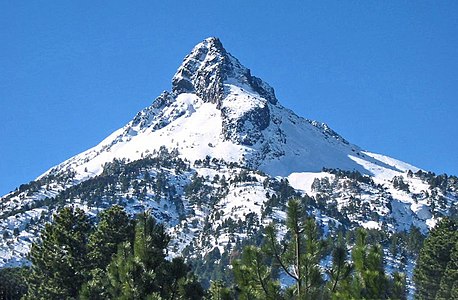
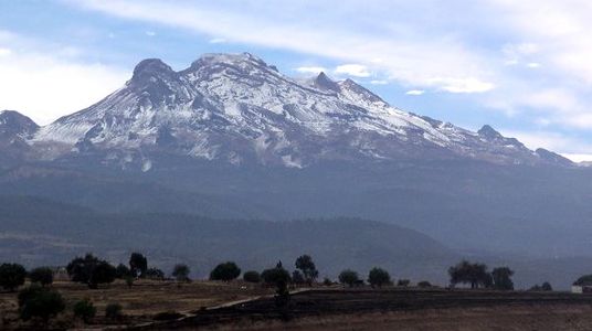 The summit of Volcán Iztaccíhuatl, a stratovolcano on the border between Puebla and México State, is the third highest peak of Mexico.


 Definitions from Wiktionary
 Media from Commons
 News from Wikinews
 Quotations from Wikiquote
 Texts from Wikisource
 Textbooks from Wikibooks
 Resources from Wikiversity