Диапазон вечности

| Диапазон вечности | |
|---|---|
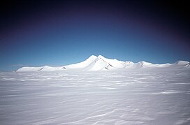 Гора благотворительность, вид с востока | |
| Самая высокая точка | |
| Пик | Гора Хоуп |
| Возвышение | 3239 м (10 627 футов) |
| Координаты | 69 ° 46 'с 64 ° 34′W / 69,767 ° S 64,567 ° W |
| Размеры | |
| Длина | 28 миль (45 км) |
| География | |
 Eternity Range | |
| Continent | Antarctica |
| Region | Palmer Land |
Диапазон вечности ( 69 ° 46 'с 64 ° 34′W / 69,767 ° S 64,567 ° W ) представляет собой диапазон гор 28 морских миль (52 км; длиной 32 мили), поднимаясь до 3239 метров (10 627 футов) [ А ] и в тренде с север -юг приблизительно в середине Антарктического полуострова . Диапазон делится на три основных горных блока, основные вершины на каждом с севера на юг - это вера, надежда и благотворительность. [ 1 ]
Расположение
[ редактировать ]
Диапазон вечности находится в северной части Палмер , между морем Уэдделла на востоке и заливом Маргаритской залива на западе. Это к востоку от Плато Дайера , к юго -востоку от Литли Пик , к югу от головы ледника Лураби , к западу от Стефанссон -Саунд и к северу от гор Колумбии . Особствами с севера на юг являются гора Вера, гора Хоуп и благотворительность на горе. Близлежащие особенности включают в себя пик Брэнд, гору Думлер и гору Салливан на восток, а также вершину Уэйкфилда Хайленда и Дэвис на севере. [ 3 ]
Discovery and name
[ редактировать ]Lincoln Ellsworth discovered the range from the air during his flights of November 21 and November 23, 1935. He applied the names Eternity Range and Mounts Faith, Hope and Charity. In November 1936, the range was surveyed by John Riddoch Rymill of the British Graham Land Expedition (BGLE) who gave the name "Mount Wakefield" to the central mountain in the range. This complication by Rymill, and uncertainty as to the precise location or extent of Ellsworth's discovery, hindered for a time a resolution of its nomenclature. Thus, following the United States Antarctic Service (USAS) expedition in 1939–41, the name Eternity Range or Eternity Mountains was incorrectly applied to the present Welch Mountains 60 nautical miles (110 km; 69 mi) farther south.[1]
A careful study of the original reports, maps and photographs, and comparison with materials from subsequent expeditions such as the Ronne Antarctic Research Expedition (RARE), 1947, and the Falkland Islands Dependencies Survey (FIDS), 1960, has led to the conclusion that the range described comprises at least the core of Ellsworth's Eternity Range and appropriately commemorates his discovery. The name "Wakefield", given by Rymill, has been transferred to nearby Wakefield Highland.[1]
Features
[edit]
Mount Faith
[edit]69°37′S 64°29′W / 69.617°S 64.483°W. A massive mountain 9 nautical miles (17 km; 10 mi) north of Mount Hope, rising to 2,650 metres (8,690 ft) high from the north end of Eternity Range. First seen from the air and named by Lincoln Ellsworth during his flights of November 21 and 23, 1935. Surveyed by J.R. Rymill of BGLE in November 1936. The mountain was subsequently photographed from the air by the US AS in September 1940, and RARE in December 1947.[4]
Mount Hope
[edit]69°46′S 64°34′W / 69.767°S 64.567°W. A massive mountain rising to 3,239 metres (10,627 ft) high[a], forming the central and highest peak of Eternity Range. First seen from the air and named Mount Hope by Lincoln Ellsworth during his flights of November 21 and 23, 1935. The mountain was surveyed and given the name Mount Wakefield by J.R. Rymill of BGLE in November 1936. The feature was subsequently photographed from the air by the USAS in September 1940, and by RARE in December 1947. A careful study of the reports, maps, and photographs of these expeditions, as well as additional survey of the area by FIDS in 1960, has led to the conclusion that Ellsworth's Mount Hope and Rymill's Mount Wakefield are synonymous. For the sake of historical continuity the name Mount Hope has been retained for this mountain, and the name Wakefield has been transferred to Wakefield Highland located close northwestward.[5]
Mount Charity
[edit]69°54′S 64°34′W / 69.900°S 64.567°W. A massive mountain 9 nautical miles (17 km; 10 mi) south of Mount Hope, rising 2,680 metres (8,790 ft) high from the south end of Eternity Range. First seen from the air and named by Lincoln Ellsworth during his flights of November 21 and 23, 1935. Surveyed by J.R. Rymill of BGLE in November 1936. The mountain was subsequently photographed from the air by the US AS in September 1940, and by RARE in December 1947. The feature is one of three major mountains in Ellsworth's Eternity Range to which he gave the names Faith, Hope and Charity.[6]
Nearby features
[edit]-
 Brand Peak
 -
 Southern Mount Duemler, view towards south
 -
 Eastern ridge of Mount Sullivan


Brand Peak
[edit]70°01′S 63°55′W / 70.017°S 63.917°W. A sharp snow-covered peak located 10 nautical miles (19 km; 12 mi) east-southeast of the Eternity Range and 4 nautical miles (7.4 km; 4.6 mi) northwest of Mount Duemler. Mapped by the United States Geological Survey (USGS) in 1974. Named by the United States Advisory Committee on Antarctic Names (US-ACAN) for Timothy Brand, USARP biologist at Palmer Station in 1974.[7]
Mount Duemler
[edit]70°01′S 63°45′W / 70.017°S 63.750°W. Mountain, 2,225 metres (7,300 ft) high, rising southwest of the head of Anthony Glacier and 11 nautical miles (20 km; 13 mi) west of Mount Bailey, inland from the east coast of Palmer Land. This feature was first chartered by the BGLE under Rymill in 1936-37. It was photographed from the air by the USAS in 1940, and the RARE under Finn Ronne in 1947, and recharted in 1947 by a joint sledge party consisting of members of the RARE and FIDS. Named by Ronne for R.F. Duemler, vice president of the Delaware, Lackawanna and Western Coal Co., New York, which contributed coal to the expedition.[8]
Mount Sullivan
[edit]69°39′S 63°49′W / 69.650°S 63.817°W. A mountain, 2,070 metres (6,790 ft) high, standing 12 nautical miles (22 km; 14 mi) east of the north part of the Eternity Range. This feature lies in the area explored from the air by Sir Hubert Wilkins in 1928 and Lincoln Ellsworth in 1935, but it was first charted by the BGLE in 1936-37. It was photographed from the air in 1940 by the USAS and in 1947 by the RARE under Ronne. Named by Ronne for Colonel H.R. Sullivan of the Office of Research and Development of the then USAAF, which furnished equipment for the expedition.[9]
Wakefield Highland
[edit]69°20′S 65°10′W / 69.333°S 65.167°W. A snow-covered highland in central Antarctic Peninsula, bounded to the north by Hermes Glacier and the heads of Weyerhaeuser Glacier and Aphrodite Glacier, to the west by the heads of Airy Glacier, Rotz Glacier and Seller Glacier, to the south by Fleming Glacier and to the east by the heads of Lurabee Glacier, Sunfix Glacier and Grimley Glacier. Photographed from the air by RARE on December 22, 1947. Surveyed by FIDS in November 1960. Named after Viscount Wakefield of Hythe, a contributor to BGLE, 1934-37. This toponym, concurred in by the UK Antarctic Place-Names Committee (UK-APC) and the US-ACAN, restores the name Wakefield in the vicinity of the BGLE's displaced "Mount Wakefield" (now Mount Hope).[10]
Davies Top
[edit]69°24′S 64°56′W / 69.400°S 64.933°W. A conspicuous isolated peak 2,360 metres (7,740 ft) high on the east side of Wakefield Highland, near the head of Lurabee Glacier. Photographed from the air by RARE on December 22, 1947. Surveyed by FIDS in November 1960. Named by UK-APC after Anthony G. Davies of FIDS, Medical Officer at Horseshoe Island and Stonington Island, 1960.[11]
See also
[edit]- Antarctandes, the Antarctic Peninsula Cordillera
Notes
[edit]- ^ Jump up to: a b Альберт (1995) дает высоту самой высокой точки на 2860 метров (9 380 футов). [1] В декабре 2017 года британская антарктическая обследование (BAS) объявила, что спутниковые данные показали, что Маунт Хоуп составлял 3239 метров (10 627 футов) высотой, самый высокий на британской антарктической территории, перемещая Маунт -Джексон на 3184 метра (10 446 футов) на второе место в Полем Гора Винсон по -прежнему является самой высокой горой в Антарктиде, на 4892 метра (16 050 футов). [ 2 ]
Ссылки
[ редактировать ]- ^ Jump up to: а беременный в дюймовый Alberts 1995 , pp. 226–227.
- ^ Новые спутниковые образы BAS .
- ^ Palmer Land Usgs .
- ^ Alberts 1995 , p. 231.
- ^ Alberts 1995 , p. 344.
- ^ Alberts 1995 , p. 129
- ^ Alberts 1995 , p. 89
- ^ Alberts 1995 , p. 202
- ^ Alberts 1995 , p. 722.
- ^ Alberts 1995 , p. 791.
- ^ Alberts 1995 , p. 175.
Источники
[ редактировать ]- Альбертс, Фред Г., изд. (1995), Географические названия Антарктики (PDF) (2 Ed.), Совет Соединенных Штатов по географическим именам , извлеченные 2023-12-03
 Эта статья включает в себя материалы общественного достояния с веб -сайтов или документов Совета США по географическим именам .
 - Новые спутниковые образы показывают новую самую высокую гору Антарктического полуострова , BAS; Британская антарктическая обследование, 11 декабря 2017 года , получено 2024-04-29
- Palmer Land , USGS: Геологическая служба США , полученная 2024-04-25
![]() Эта статья включает в себя материалы общественного достояния с веб -сайтов или документов Геологической службы США .
Эта статья включает в себя материалы общественного достояния с веб -сайтов или документов Геологической службы США .