Тхенгский район

Эта статья нуждается в дополнительных цитатах для проверки . ( июль 2019 г. ) |
Затем
Тэн | |
|---|---|
 | |
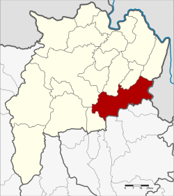 District location in Chiang Rai province | |
| Coordinates: 19°41′8″N 100°11′37″E / 19.68556°N 100.19361°E | |
| Country | Thailand |
| Province | Chiang Rai |
| Area | |
| • Total | 821.0 km2 (317.0 sq mi) |
| Population (2005) | |
| • Total | 84,507 |
| • Density | 102.9/km2 (267/sq mi) |
| Time zone | UTC+7 (ICT) |
| Postal code | 57160 |
| Geocode | 5704 |
Тхоенг ( тайский : Тхоенг ; IPA: [thɤ̄ːŋ] ) — район ( амфоя ) в восточной провинции Чианграй , северный Таиланд .
География
[ редактировать ]расположен Па Даэт - Чианграй юго на провинции западе . находится на востоке Провинция Бокео в Лаосе — на юге. а провинция Пхаяо ,
Thoeng is a mountainous district. The conspicuous 1,174 m high Doi Ian rises 12 km to the east and 823 m high Doi Kham rises four km south of the town between Thoeng and Chiang Kham. There are some higher mountains in the east of the district such as 1,013 m high Doi Pha Mon and 1,442 m high Phu Chi Fa at the border with Wiang Kaen District.[1] The Ing River, with its source in the Phi Pan Nam Range (Doi Luang in Mae Chai district, Phayao Province) flows through the plain area of Thoeng. Other rivers in the area are the Lao River, a tributary of the Kok River, from Doi Phu Lang Ka, Chiang Kham district, in the north and Ngao River from Doi Pha Mon and the Plong River.[2]
Administration
[edit]The district is divided into 10 subdistricts (tambons), which are further subdivided into 175 villages (mubans). There are two townships (thesaban tambons): Wiang Thoeng covers parts of tambon Wiang, and Ban Plong covers parts of tambon Plong. There are a further 10 sub-district administrative organizations (SAO).
| No. | Name | Thai name | Villages | Pop. | |
|---|---|---|---|---|---|
| 1. | Wiang | เวียง | 24 | 16,004 | |
| 2. | Ngio | งิ้ว | 23 | 12,589 | |
| 3. | Plong | ปล้อง | 12 | 8,612 | |
| 4. | Mae Loi | แม่ลอย | 13 | 7,015 | |
| 5. | Chiang Khian | เชียงเคี่ยน | 10 | 4,655 | |
| 9. | Tap Tao | ตับเต่า | 26 | 12,252 | |
| 10. | Ngao | หงาว | 20 | 9,943 | |
| 11. | San Sai Ngam | สันทรายงาม | 7 | 4,308 | |
| 12. | Si Don Chai | ศรีดอนไชย | 9 | 4,892 | |
| 13. | Nong Raet | หนองแรด | 7 | 4,237 |
Missing numbers belong to tambons which now form Khun Tan District.
References
[edit]- ^ "Thoeng". Archived from the original on 2012-01-04. Retrieved 2012-01-09.
- ^ Amphoe Thoeng[permanent dead link]
External links
[edit] Chiang Rai Province travel guide from Wikivoyage
- amphoe.com (Thai)
This Chiang Rai province location article is a stub. You can help Wikipedia by expanding it. |