Арканзасское шоссе 309
 Шоссе 309 | ||||
|---|---|---|---|---|
| Mount Magazine Scenic Byway [ 1 ] | ||||
 | ||||
| Информация о маршруте | ||||
| Поддерживается Ardot | ||||
| Раздел 1 | ||||
| Длина | 5,11 миль [ 2 ] (8,22 км) | |||
| Уэст -Энд | ||||
| Ист -Энд | ||||
| Section 2 | ||||
| Length | 42.90 mi[2] (69.04 km) | |||
| West end | ||||
| East end | ||||
| Location | ||||
| Country | United States | |||
| State | Arkansas | |||
| Counties | Yell, Logan, Franklin | |||
| Highway system | ||||
| ||||
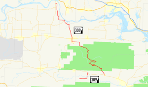
Арканзасское шоссе 309 ( AR 309 и Hwy. 309 ) является обозначением двух государственных автомагистралей в Западном Арканзасе . Один маршрут в 5,11 мили (8,22 км) проходит от маршрута округа Йелл 28 (CR 28) на озере Голубой горы на северо -востоке до шоссе 10 в Waveland . [ 3 ] Второй сегмент начинается на шоссе 10 в Гаване и ветра на северо -западе через Национальный лес Озарк до шоссе 23 в городе Уэбб через Париж . [ 3 ] [ 4 ] [ 5 ] Часть второго маршрута обозначена как Mount Magazine Scenic Byway , один из одиннадцати живописных Arkansas Scenic, поддерживаемых Департаментом шоссе и транспорта штата Арканзас (AHTD).
Описание маршрута
[ редактировать ]Голубое горный озеро до волны
[ редактировать ]Шоссе 309 начинается на маршруте округа Йелл 28 возле озера Голубой горы в округе Йелл . Маршрут проходит на восток и поворачивается на север, чтобы закончить на шоссе 10 . [ 3 ] Это выравнивание не пересекает никаких других государственных автомагистралей. Среднесуточное количество транспортных средств от 2010 года показало, что 630 автомобилей в день используют этот сегмент шоссе 309. [2]
Havana to Webb City
[edit]
A second, longer routing of Highway 309 begins in Havana at Highway 10. The route begins north through the Ozark National Forest. The route runs near the Cove Creek Bridge, Burnett Springs, and the Cove Lake Bathhouse and Cove Lake Spillway Dam-Bridge near Cove Lake. The highway also passes over the Cove Creek Tributary Bridge prior to exiting the forest northbound to Paris. Along this route lies the small town of Roseville. According to local folklore Roseville missed out on being the capital of Arkansas by only one vote. Whither this is true or not has never been proven, but this story has been passed down from generation to generation and survives til this day.[6]
Upon entering the northern county seat of Logan County Highway 309 forms a concurrency with Highway 109 in south Paris, continuing north to Highway 22. This junction also contains Logan County Courthouse and the Paris Commercial Historic District on the National Register of Historic Places. Highway 309 continues north past the Methodist Episcopal Church, and Paris Post Office to exit town heading north. The route runs north, briefly along the Arkansas River before it enters Franklin County. The route runs almost due north to Webb City, where it terminates at Highway 23.
Mount Magazine Scenic Byway
[edit]
A segment of 20.4 miles (32.8 km) winds from Havana north through the Ozark National Forest to an area south of Paris.[7] The route passes by Mount Magazine, which at 2,753 feet (839 m) is Arkansas's highest point.[8] Recreation areas include Cove Lake and Mt. Magazine Recreation Areas, with views of Blue Mountain Lake available from an overlook.[9] Many current camp sites are former home sites that were bought by the government during the depression.
Major intersections
[edit]Mile markers reset at concurrencies.
| County | Location | mi[2] | km | Destinations | Notes | ||
|---|---|---|---|---|---|---|---|
| Yell | Blue Mountain Lake | 0.00 | 0.00 | Western terminus | |||
| Waveland | 5.11 | 8.22 | Eastern terminus | ||||
| Gap in route | |||||||
| Havana | 0.00 | 0.00 | Western terminus | ||||
| Logan | Paris | 26.93 | 43.34 | ||||
| 0.00 | 0.00 | ||||||
| Roseville | 7.43 | 11.96 | |||||
| Franklin | Webb City | 15.97 | 25.70 | Eastern terminus | |||
1.000 mi = 1.609 km; 1.000 km = 0.621 mi
| |||||||
Former route
[edit]Highway 309 | |
|---|---|
| Location | Ozark |
| Length | 1.84 mi[2] (2.96 km) |
| Existed | March 26, 1975[10]–September 25, 1991[11] |
Highway 309 (AR 309, Ark. 309, and Hwy. 309) is a former route in Ozark. The route of 1.84 miles (2.96 km) began at Highway 23 and ran east to Highway 219. It was redesignated as Highway 96 in 1991 due to traveler confusion with the existing section of Highway 309.
History
[edit]Highway 309 was first added to the state highway system as a 0.5 miles (0.80 km) access road to the Ozark Municipal Airport by the Arkansas State Highway Commission on March 26, 1975.[10] The Commission requested a study regarding extending the route east to Highway 219 on July 31, 1975,[12] and requested an update to that study on March 22, 1978.[13] Although the Commission requested the study's findings be reported at a later meeting, no record of the report's findings exist in subsequent meeting minutes between 1978 and June 1, 1991, when the Commission authorized the extension to Highway 219.[14] Three months later, the Commission redesignated the highway as Highway 96 due to confusion between the two eastbound routes with junctions on Highway 23 within a few miles of each other.[11]
Major intersections
[edit]The entire route was in Ozark, Franklin County.
| mi[11] | km | Destinations | Notes | ||
|---|---|---|---|---|---|
| 0.00 | 0.00 | Southern terminus | |||
| 1.84 | 2.96 | Northern terminus | |||
| 1.000 mi = 1.609 km; 1.000 km = 0.621 mi | |||||
See also
[edit]References
[edit]- ^ "Mount Magazine Scenic Byway/Highway 309." Arkansas State Highway and Transportation Department, Scenic Byways Program. Link Retrieved July 8, 2011.
- ^ Jump up to: a b c d e "[Arkansas] State Highways 2009 (Database)." April 2010. AHTD: Planning and Research Division. Database. Archived 2011-07-07 at the Wayback Machine Retrieved April 3, 2011.
- ^ Jump up to: a b c General Highway Map, Yell County, Arkansas (PDF) (Map). 1:62500. Cartography by Planning and Research Division. Arkansas State Highway and Transportation Department. 2002. Retrieved November 22, 2011.
- ^ General Highway Map, Logan County, Arkansas (PDF) (Map). 1:62500. Cartography by Planning and Research Division. Arkansas State Highway and Transportation Department. 2002. Retrieved November 22, 2011.
- ^ Генеральная карта шоссе, округ Франклин, Арканзас (PDF) (MAP). 1: 62500. Картография по планированию и исследовательскому отделу. Арканзас Государственный шоссе и транспортный отдел. 2011 год Получено 22 ноября 2011 года .
- ^ Lancaster, Guy. "Folkloric Relocations of the Arkansas State Capitol". Retrieved 7 August 2012.
- ^ "Mount Magazine Scenic Byway". United States Department of Transportation. Archived from the original on March 20, 2007. Retrieved November 22, 2011.
- ^ "Magazine Mountain." U.S. Geological Survey Geographic Names Information System: Arkansas Highway 309 United States Geological Survey. Retrieved November 22, 2011.
- ^ "Mount Magazine Scenic Byway". February 28, 2006. Archived from the original on November 7, 2011. Retrieved November 22, 2011.
- ^ Jump up to: a b "Minutes" (1970–79), p. 789.
- ^ Jump up to: a b c "Minutes" (1990–99), p. 173.
- ^ "Minutes" (1970–79), p. 874.
- ^ "Minutes" (1970–79), p. 249.
- ^ "Minutes" (1990–99), p. 142.
- «Протокол встречи» (PDF) . Арканзасская государственная комиссия по шоссе. 1970–1979. Архивировано из оригинала (PDF) 5 ноября 2011 года . Получено 22 ноября 2016 года .
- «Протокол встречи» (PDF) . Арканзасская государственная комиссия по шоссе. 1990–1999. Архивировано из оригинала (PDF) 21 июля 2019 года . Получено 22 ноября 2016 года .
Внешние ссылки
[ редактировать ]![]() СМИ, связанные с Арканзасским шоссе 309 в Wikimedia Commons
СМИ, связанные с Арканзасским шоссе 309 в Wikimedia Commons