Jump to content

Wetteraukreis

Coordinates: 50°22′N 8°55′E / 50.367°N 8.917°E / 50.367; 8.917
Wetteraukreis
Flag of Wetteraukreis
Coat of arms of Wetteraukreis
Map
CountryGermany
StateHesse
Adm. regionDarmstadt
CapitalFriedberg
Government
 • District admin.Jan Weckler (CDU)
Area
 • Total1,101.71 km2 (425.37 sq mi)
Population
 (31 December 2022)[1]
 • Total317,298
 • Density290/km2 (750/sq mi)
Time zoneUTC+01:00 (CET)
 • Summer (DST)UTC+02:00 (CEST)
Vehicle registrationFB, BÜD
Websitewww.wetteraukreis.de

The Wetteraukreis is a Kreis (district) in the middle of Hesse, Germany. Neighbouring districts are Landkreis Gießen, Vogelsbergkreis, Main-Kinzig-Kreis, district-free Stadt Frankfurt, Hochtaunuskreis and Lahn-Dill-Kreis.

History

[edit]

The district was created in 1972 when the two districts Friedberg and Büdingen were merged.

Geography

[edit]
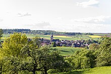
Area view of Eckartshausen

The district is located between the Taunus mountains and the Vogelsberg volcanic mountain. The main rivers of the district are the Nidda River and the Wetter River.

Coat of arms

[edit]

The imperial eagle in the top of the coat of arms was chosen because the Wetterau was imperial possession in the past. The bars in the bottom derive from the lords of Isenburg-Büdingen, who owned most of the area. The wavy line depicts the river Wetter which flows through the capital Friedberg.

Towns and municipalities

[edit]
ButzbachMünzenbergRockenbergOber-MörlenBad NauheimFriedbergRosbach vor der HöheWöllstadtKarbenBad VilbelWölfersheimReichelsheimNiddatalFlorstadtEchzellReichelsheimNiddaHirzenhainGedernRanstadtGlauburgAltenstadtLimeshainOrtenbergKefenrodBüdingenLahn-Dill-KreisGießen (district)VogelsbergkreisHochtaunuskreisFrankfurtMain-Kinzig-Kreis
Clickable map of towns and municipalities in the district
TownsMunicipalities
  1. Bad Nauheim
  2. Bad Vilbel
  3. Büdingen
  4. Butzbach
  5. Florstadt
  6. Friedberg
  7. Gedern
  8. Karben
  9. Münzenberg
  10. Nidda
  11. Niddatal
  12. Ortenberg
  13. Reichelsheim
  14. Rosbach vor der Höhe
  1. Altenstadt
  2. Echzell
  3. Glauburg
  4. Hirzenhain
  5. Kefenrod
  6. Limeshain
  7. Ober-Mörlen
  8. Ranstadt
  9. Rockenberg
  10. Wölfersheim
  11. Wöllstadt

References

[edit]
  1. ^ "Bevölkerung in Hessen am 31.12.2022 nach Gemeinden" (XLS) (in German). Hessisches Statistisches Landesamt. June 2023.
[edit]

Media related to Wetteraukreis at Wikimedia Commons

50°22′N 8°55′E / 50.367°N 8.917°E / 50.367; 8.917

Arc.Ask3.Ru: конец переведенного документа.
Arc.Ask3.Ru
Номер скриншота №: 504b78bc2658d3cca01422c9b4ee6f1d__1713306540
URL1:https://arc.ask3.ru/arc/aa/50/1d/504b78bc2658d3cca01422c9b4ee6f1d.html
Заголовок, (Title) документа по адресу, URL1:
Wetteraukreis - Wikipedia
Данный printscreen веб страницы (снимок веб страницы, скриншот веб страницы), визуально-программная копия документа расположенного по адресу URL1 и сохраненная в файл, имеет: квалифицированную, усовершенствованную (подтверждены: метки времени, валидность сертификата), открепленную ЭЦП (приложена к данному файлу), что может быть использовано для подтверждения содержания и факта существования документа в этот момент времени. Права на данный скриншот принадлежат администрации Ask3.ru, использование в качестве доказательства только с письменного разрешения правообладателя скриншота. Администрация Ask3.ru не несет ответственности за информацию размещенную на данном скриншоте. Права на прочие зарегистрированные элементы любого права, изображенные на снимках принадлежат их владельцам. Качество перевода предоставляется как есть. Любые претензии, иски не могут быть предъявлены. Если вы не согласны с любым пунктом перечисленным выше, вы не можете использовать данный сайт и информация размещенную на нем (сайте/странице), немедленно покиньте данный сайт. В случае нарушения любого пункта перечисленного выше, штраф 55! (Пятьдесят пять факториал, Денежную единицу (имеющую самостоятельную стоимость) можете выбрать самостоятельно, выплаичвается товарами в течение 7 дней с момента нарушения.)