Trambileno
Trambileno | |
|---|---|
| Comune di Trambileno | |
 | |
Location of Trambileno | |
| Coordinates: 45°52′N 11°4′E / 45.867°N 11.067°E | |
| Country | Italy |
| Region | Trentino-Alto Adige/Südtirol |
| Province | Trentino (TN) |
| Frazioni | Acheni, Boccaldo, Ca' Bianca, Clocchi, Dosso, Giazzera, Lesi, Moscheri (sede comunale), Porte, Pozza, Pozzacchio, Rocchi, San Colombano, Sega, Spino, Toldo, Vanza, Vignala |
| Government | |
| • Mayor | Franco Vigagni |
| Area | |
| • Total | 50.7 km2 (19.6 sq mi) |
| Elevation | 525 m (1,722 ft) |
| Population (31 December 2015)[2] | |
| • Total | 1,452 |
| • Density | 29/km2 (74/sq mi) |
| Demonym | Trambeleri |
| Time zone | UTC+1 (CET) |
| • Summer (DST) | UTC+2 (CEST) |
| Postal code | 38068 |
| Dialing code | 0464 |
| Website | Official website |
Trambileno (Trambelém in local dialect) is a comune (municipality) in Trentino in the northern Italian region Trentino-Alto Adige/Südtirol, located about 25 kilometres (16 mi) south of Trento.
Trambileno borders the following municipalities: Rovereto, Terragnolo, Vallarsa, Posina and Valli del Pasubio.
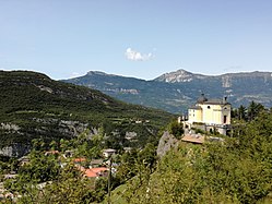
It is known as the location of the Eremo di San Colombano monastery, a church set on a rock ledge.
Twin towns
[edit] Bento Gonçalves, Brazil, since 2007
References
[edit]- ^ "Superficie di Comuni Province e Regioni italiane al 9 ottobre 2011". Italian National Institute of Statistics. Retrieved 16 March 2019.
- ^ All demographics and other statistics: Italian statistical institute Istat.


