Temelín

Temelín | |
|---|---|
 Temelín Nuclear Power Station | |
 Flag  Coat of arms | |
 Temelín Location in the Czech Republic | |
| Coordinates: 49°11′34″N 14°20′56″E / 49.19278°N 14.34889°E | |
| Country | |
| Region | South Bohemian |
| District | České Budějovice |
| First mentioned | 1381 |
| Area | |
| • Total | 50.40 km2 (19.46 sq mi) |
| Elevation | 443 m (1,453 ft) |
| Population (2024-01-01)[1] | |
| • Total | 896 |
| • Density | 18/km2 (46/sq mi) |
| Time zone | UTC+1 (CET) |
| • Summer (DST) | UTC+2 (CEST) |
| Postal codes | 373 01, 375 01 |
| Website | www |
Temelín (German: Groß Temelin) is a municipality and village in České Budějovice District in the South Bohemian Region of the Czech Republic. It has about 900 inhabitants. It is known for the Temelín Nuclear Power Station.
Administrative parts
[edit]The villages of Kočín, Lhota pod Horami, Litoradlice, Podhájí, Sedlec and Zvěrkovice and the areas of the abandoned villages of Březí u Týna nad Vltavou, Knín, Křtěnov and Temelínec are administrative parts of Temelín.
Etymology
[edit]The name is derived from the personal name Temela.[2]
Geography
[edit]Temelín is located about 25 kilometres (16 mi) north of České Budějovice. It lies mostly in the Tábor Uplands, only the western part of the municipal territory with the villages of Lhota pod Horami and Sedlec lies in the České Budějovice Basin. The highest point is a hill at 525 m (1,722 ft) above sea level. The eastern municipal border is formed by the Vltava river and by the Hněvkovice Reservoir, built on the Vltava. The area is rich in small fishponds.
History
[edit]The first written mention of Temelín is from 1381. From 1482 until the establishment of an independent municipality in 1850, it was a part of the Neznašov estate.[2]
In the 1980s, the villages of Březí u Týna nad Vltavou, Knín, Křtěnov and Temelínec were demolished for the construction of the power plant.[3]
Demographics
[edit]
|
|
| ||||||||||||||||||||||||||||||||||||||||||||||||||||||
| Source: Censuses[4][5] | ||||||||||||||||||||||||||||||||||||||||||||||||||||||||
Economy
[edit]Temelín Nuclear Power Station, one of the two Czech nuclear power plants, is located in the municipality.
Transport
[edit]A railway runs through the municipal territory, but there is no passenger transport.
Sights
[edit]
The main historical landmark of the municipality is the Church of Saint Procopius. It was built in the Gothic style around 1300. In the 18th century, it was partially rebuilt and modified in the Baroque style. Next to the church is a separate bell tower from the 16th century. The church is the last remnant of the abandoned village of Křtěnov.[6]
Vysoký Hrádek Castle is located next to the nuclear power station, in the area of Březí u Týna nad Vltavou. It is a Renaissance castle that houses the information centre of the nuclear power station.[7]
The Býšov Fortress is located in the area of Knín. It dates from the 14th century.[8]
In the centre of Temelín is a chapel from around 1905.[2]
Gallery
[edit]-
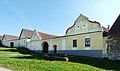 Kočín
Kočín -
 Chapel of Saint Procopius in Kočín
 -
 Panský pond
 -
 Býšov fortress in Knín
 -
 Vysoký Hrádek Castle


See also
[edit]- Dukovany, the second Czech municipality with a nuclear power station
References
[edit]- ^ "Population of Municipalities – 1 January 2024". Czech Statistical Office. 2024-05-17.
- ^ Jump up to: a b c "Temelín a přidružené obce" (in Czech). Obec Temelín. Retrieved 2024-02-07.
- ^ "Museli vymést celý dům, pak jim ho zbořili. Po vesnicích u Temelína nezbylo skoro nic" (in Czech). Czech Radio. 2019-08-11. Retrieved 2024-02-07.
- ^ "Historický lexikon obcí České republiky 1869–2011" (in Czech). Czech Statistical Office. 2015-12-21.
- ^ "Population Census 2021: Population by sex". Public Database. Czech Statistical Office. 2021-03-27.
- ^ "Kostel sv. Prokopa" (in Czech). National Heritage Institute. Retrieved 2024-02-07.
- ^ "Informační centrum Temelín (Zámek Vysoký Hrádek)". budejce.cz (in Czech). City of České Budějovice. Retrieved 2024-02-07.
- ^ "Tvrz Býšov" (in Czech). National Heritage Institute. Retrieved 2024-02-07.