Karasu (village)

Karasu
Қарасу | |
|---|---|
Village | |
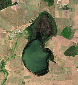 Karasu by lake Koybagar | |
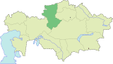
 Karasu Location in Kazakhstan | |
| Coordinates: 52°39′32″N 65°29′9″E / 52.65889°N 65.48583°E | |
| Country | Kazakhstan |
| Region | Kostanay Region |
| District | Karasu District |
| Population (2019) | |
| • Total | 3,476 |
| Time zone | UTC+6 (East Kazakhstan Time) |
| Post code | 030101 |
Karasu (Kazakh: Қарасу) is a village in the Kostanay Region, Kazakhstan. It is the administrative center and the only significant inhabited place of Karasu District (KATO code - 395230100).[1] Population: 3,728 (2009 Census results);[2] 4,374 (1999 Census results).[2][3]
Geography
[edit]The village is located 5 kilometers (3.1 mi) to the west of the northern shore of lake Koybagar, at a bend in river Karasu, which flows northwards, and then bends eastwards into the western shore of the lake.[4][5]
Climate
[edit]| Climate data for Karasu (1991–2020) |
|---|
References
[edit]- ^ "База КАТО". Агентство Республики Казахстан по статистике. Archived from the original on 2013-09-27.
- ^ Jump up to: a b "Население Республики Казахстан" [Population of the Republic of Kazakhstan] (in Russian). Департамент социальной и демографической статистики. Retrieved 8 December 2013.
- ^ "Итоги Национальной переписи населения Республики Казахстан 2009 года" (PDF). Агентство Республики Казахстан по статистике. Archived from the original (PDF) on 2013-05-13.
- ^ "N-41 Topographic Chart (in Russian)". Retrieved 16 August 2022.
- ^ Google Earth.
- ^ "World Meteorological Organization Climate Normals for 1991-2020 — Karasu". National Oceanic and Atmospheric Administration. Retrieved January 2, 2024.
This Kazakhstan location article is a stub. You can help Wikipedia by expanding it. |