Формирование Блэкхока
| Формирование Блэкхока | |
|---|---|
| Стратиграфический диапазон : кампания ~ | |
 Уголь, песчаники и углеродистые мудры в формировании Блэкхока, выставленные вдоль американского шоссе 6, Прайс -Каньон, округ Карбон, штат Юта. | |
| Тип | Геологическое образование |
| Расположение | |
| Область | Юта |
| Страна | |

Формирование Блэкхока -это геологическая формация в Восточной Центральной Юте, США А. Он был назван в честь бывшего города Блэкхок на восточной стороне плато Устах, округ Карбон. [ 1 ] Формирование состоит в основном из светло-коричневого, светло-серого и коричневато-серого, тонко-кровопроката, из тонкого и среднего квартального песчаника, который смешивается с блестящим алером, сланцем, углеродистым сланцем и углем. [ 2 ] Существует много тонких или толстых битумных угольных швов, в том числе несколько экономически важных слоев, таких как уголь суннисайда. Толщина образования колеблется от около 120 м (400 футов) до примерно 270 м (900 футов). Он соответственно перекрывает песчаник Star Point и несогласованно лежит в основе песчаника Castlegate.

Отложения, которые сформировали формирование Блэкхока, возникли из -за эрозии подъема Севье в Западной Юте. [ 2 ] Этот осадок был доставлен на восток реками и нанесен на западный побережье мелового морского пути. В это время морской путь также снимал (регрессию) на восток, но это было нерегулярно, со случайными эпизодами, продвигающимися (трансгрессии), охватывают прибрежные земли. Эта трансгрессия была частично в результате колеблющихся (юстатических) глобальных изменений уровня моря и частично в результате сменного положения дельт. [3][4] These events created wedges of terrestrial sedimentary rock between wedges of marine sedimentary rock (Mancos Shale). These wedges of the Blackhawk Formation have been given names and many of them contain economically important bituminous coal zones, such as the Kenilworth Coal that is up to 11 m (37 feet) thick.[3] The coast probably resembled the Gulf Coast today, being composed of a broad coastal plain, with meandering rivers that ended in wave-dominated deltas. These deltas were flanked by sandy beaches.[4] Swamps were probably developed on the delta plains and on the floodplain (bottomlands) adjacent to the meandering rivers, rather than in brackish-water of lagoons because of the low sulfur content of the coals.[4]

Paleontology
[edit]Fossil plants are extremely common in the Blackhawk Formation.[5] Their distribution is closely tied to specific environments, just like plants are today. The plant community of the swamp environment was dominated by the evergreen conifer Sequoia cuneata and a deciduous angiosperm tree Rhamnites eminens. Other, less abundant trees include Protophyllocladus polymorpha, Moriconia cyclotoxon, Brachyphyllum squammnosum, Podozamites sp., and the angiosperms “Cissus” marginata, Platanus raynoldsii, "Cornus” praetimpressa, Dryophyllum subfalcatum, “Ficus” planicostata, and Myrtophyllum torreyii.[6] Near the swamp margins a small palm, Phoenocites imperialis, grew in thickets. The palm Sabalites grayanus was also present, although not in abundance. The herbaceous understory was composed entirely of two ferns, Cyathea pinnata and Onoclea herbridica. The aquatic plants include a water lily, Nymphaeites dawsoni, a water chestnut, Trapa paulula, and a cattail, Cyperacites. The bottomland community was dominated by the angiosperm trees Platanus raynoldsii and Dryophyllum subfalcatum. Other angiosperm trees also present, but in lesser abundance include Phoenocites, “Cercidophyllum” arcticum, “Ficus” laurophylla, Laurophyllum coloradensis, Manihotites georgiana, Platanus alata, Menispermites sp., and “Viburnum” antiquum; conifers were absent. Ferns were the only understory plants. Overall, the plant communities looked similar to those along the Gulf Coast, although the Blackhawk communities had a larger proportion of conifers and few, if any herbaceous angiosperms in the swamp and bottomland forest understories.[6] Based on angiosperm leaf physiognomy (leaf size, leaf margins and dripping tips), the predominance of medium-size leaves with entire (non-serrated) margins and dripping tips, indicate that the climate was warm temperate- to subtropical, but not tropical.[5] Growth rings in conifer logs and leaf mats from seasonal shedding, also suggests the climate was seasonal. Charcoal occurs indicating that wildfires occasionally swept through the area during the dry season.

Various vertebrates are known to have inhabited the Blackhawk paleoenvironments. These include rare bone fossils of fishes, turtles and crocodiles in the collections of the Prehistoric Museum in Price Utah. The most abundant vertebrate fossils are the tracks of dinosaurs, including the blunt, three-toed hadrosaurs, long, slendered toed theropods, and the short-wide, four-toed ceratopsians.[7][8] Most of these tracks are found in the mine roof when the coal is removed. They formed when the foot of the living animals pressed into the peat of the swamp bottom. Later, sheets of sand were deposited across the swamp during floods filling in the footprints. Thus, the footprints seen represent the bottom of the foot. The larger tracks used to be removed because of their tendency to fall from the roof and many houses in Carbon and Emery Counties in Utah had a footprint or two in their yards.
Some tracks have elongated heels, which indicate the individuals slipping on exposed wet mud (slipping does not happen in standing water). One of these elongated hadrosaur tracks was named Dinosauropodes and heralded as the footprint of the world's biggest dinosaur.[9] The largest hadrosaur tracks are over 62 cm (24 in.) wide, indicating the presence of huge hadrosaurs the size of Shantungosaurus from China. As yet, no bones of hadrosaurs this size are not known from the Blackhawk Formation. Possible pterosaur tracks have been reported[10] from the Kenilworth Mine near Helper, Utah. Problematically, however, these tracks seem to be only those of the wing-hand and do not include any foot (pes) tracks. These asymmetrical three-digit tracks were previously thought to belong to the aquatic bird Hesperornis.[7] A few, rare dinosaur bones have been recovered from the mines, including ceratospian and possibly hadrosaur.[11]
The hadrosaur tracks from the Blackhawk Formation provide insights into the behavior of these dinosaurs that is not available from their skeletons.[8] These tracks provide a snapshot into the lives of these dinosaurs. First, hadrosaur tracks are by far the most abundant of the track types, which supports the observation from bone beds that hadrosaurs were numerically the most abundant dinosaurs during the Late Cretaceous of North America. We can see this in a map of tracks from the Kenilworth Mine. Although one individual milling around can leave hundreds of tracks, the abundance of different sized tracks and that some trackways indicate individuals passing through suggests that a herd of different-sized hadrosaurs had made the tracks. Some of the tracks seems to show individuals standing at the base of conifer trees, whose spreading roots indicate trees in growth position (see red tracks on map). These individuals may have been feeding,[8] thus supporting the hypothesis by Yale paleontologist John Ostrom that hadrosaurs fed on conifers. The map also shows numerous isolated tracks due in part to the removal of some tracks by the miners or to the differential firmness of the swamp floor. Firmer mud, such as late in the dry season or during prolonged droughts, would not leave deep tracks; in support of this, mud cracks are known from the mines,[7] as is charcoal from fires (called fusain). The hadrosaur tracks from the Blackhawk Formation also contain some of the smallest known tracks. Assuming that the smallest ones, ~3.5 cm (1.25 in) are real and not carved, these would indicate hatchling-sized individuals around 40 cm (16 in,) long.[8] Other, slightly larger tracks preserved on a rock slab are reliably 4 to 5 cm (1.5-2 in.) wide and made by individuals a little less than a meter long. The presence of these small tracks from coal swamp deposits are important because they indicate the presence of nearby nesting grounds, which unfortunately, have not yet been found. The full size range of tracks from the coal mines indicate individuals from 0.4 m (1.25 ft.) to 16 m (52.5 ft.) and that this species spent its entire life in the swamps.
Unfortunately, because of the use of long-wall mining now, which is less wasteful than the old room-and-pillar method, the recovery of dinosaur tracks and bones from mines in the Blackhawk Formation, has all but dried-up.
Paleobiota
[edit]Flora
[edit]Charophyta
Chlorophyceae
Pediastrum sp.
Sphenopsida
Equisetum sp.
Pteropsida
Allantodiopsis erosa
Cyathea pinnata
Onoclea hebridica
Osmunda hollicki
Saccoloma gardneri
Cycadophyta
Nageiopsis sp. Podozamites sp.
Coniferophyta
Androvettia sp.
Araucarites sp.
Brachyphyllum squammnosum
Geinitzia reichenbachii
Metasequoia sp.
Moriconia cyclotoxon
Protophyllocladus polymorpha
Protophyllocladus sp.
Sequoia cuneata
Taxoidioxylon sp.
Widdringtonites reichii
Magnoliophyta
Annona robusta
Apocynophyllum giganteum
Cercidiphyllum arcticum
"Cissus" marginata
"Cornus" praeimpressa
Cyperacites sp.
Dryophyllum sp.
Dryophyllum subfalcatum
"Ficus" laurophylla
"Ficus" planicostata
Phoenocites imperialis
Laurophyllum coloradensis
Manihotites georgiana
Menispermum dauricumoides
Myrtophyllum torreyi
Nymphaeites dawsoni
Platanus alata
Platanus raynoldsii
Rhamnites eminens
Sabalites grayanus
Trapa paulula
Salix proteaefolia
Viburnum antiguum
Invertebrate Trace Fossils
[edit]Asterosoma
Aulichnites
Chondrites
Gyrochorte
Helminthoida
Ophiomorpha
Pelecypodichnus
Teichichnus
Terebellina
Thalassinoides
Invertebrates
[edit]Anomia
Brachidontes
Corbula
Crassostrea
Урсирив
Вивипарус
Позвоночные
[ редактировать ]Остехри
Lepisosteus sp. Телеост
Черепахи
Basilemys sp. Trionychidae
Крокодилия
Птерозаврия (Ихнофоссил)
Theropoda (Ichnofossil)
Ceratopsia (Ichnofossil и Bone)
Галерея
[ редактировать ]-
 Серия роста небольших треков Hadrosaur, доисторический музей, Прайс, Юта
 -
 Вероятные цератопсские треки. Доисторический музей, Прайс, Юта
 -
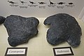 Сравнение цератопсского трека (слева) и дорожки хадрозавра (справа). Доисторический музей, Прайс, Юта.
 -
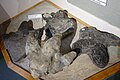 Разнообразие больших дорожек адрозавров из угольных шахт, округ Карбон, штат Юта. Доисторический музей, Прайс, Юта.
 -
 Актер " Dinosauropodes ", на самом деле дорожка Хадразавра с удлиненным каблуком от проскальзывания на влажную грязь. Доисторический музей, Прайс, Юта.


Смотрите также
[ редактировать ]Ссылки
[ редактировать ]- ^ Spieker, Em, и Reeside, JB, Jr., 1925, меловые и третичные формирования плато Уосатч, штат Юта: Геологическое общество Америки, Бюллетень, т. 36, нет. 3, с. 435-454.
- ^ Подпрыгнуть до: а беременный Weiss, MP, Witkind, IJ и Cashion, WB, 2003. Геологическая карта цены 30 x 60ʹ четырехугольник, углерод, Дюхшн, Уинта, Юта и Васатч, штат Юта. Юта Геологическая служба карта 198dm. [1]
- ^ Подпрыгнуть до: а беременный Chan, MA, Newman, SL и May, Fe, 1991. Дельтаические и напользу в меловой формировании Блэкхок и сланцу Mancos. Гранд округ, штат Юта: Геологическая служба штата Юта, Разное публикация 91-6.
- ^ Подпрыгнуть до: а беременный в дюймовый и Balsley, JK, 1983. Delta Systems, с доминирующими волнами: Книжные скалы, Восточная Центральная Юта. Геологическое общество Оклахома -Сити, короткий курс. 219 с.
- ^ Подпрыгнуть до: а беременный в Parker, LR, 1976. Палеоэкология речных угольных болот и связанных с ними пойм в формировании Блэкхока (верхняя меловая) Центральная Юта. Bigham Young University Geology Studies v. 22, pt. 3, с. 99-116.
- ^ Подпрыгнуть до: а беременный в Tidwell, WD, Britt, BB и Tidwell, LS, 2007. Обзор меловой флоры Восточной Центральной Юты и Западного Колорадо. В Willis, GC, Hylland, MD, Clark, D, L и Chidsey, TC, редакторы, Центральная Юта: разнообразная геология динамического ландшафта, публикация Геологической ассоциации штата Юта 36, стр/ 467-482.
- ^ Подпрыгнуть до: а беременный в Parker, LR, и Balsley, JK, 1989, угольные шахты в качестве населенных пунктов для изучения окаменелостей с трассирами динозавров, в Gillette, DD, и Lockley, MG, редакторы, дорожки динозавров и следы: Нью -Йорк, Кембридж Университет, издательство, с. 353–359.
- ^ Подпрыгнуть до: а беременный в дюймовый Carpenter, K., 1992, Поведение гадрозавров, как интерпретируется с следах в группе «Месаверде» (Кампании) Колорадо, Юта и Вайоминг: вклад в геологию, Университет Вайоминга, т. 29, с. 81–96.
- ^ Стревелл, CN. 1932. Dinosauropodes. Самостоятельно опубликованная, Солт-Лейк-Сити, 16 с.
- ^ Lockley, M.; Харрис, JD; и Митчелл, Л. 2008. «Глобальный обзор птерозавра ихнологии: распределение на трекости в пространстве и времени». Zitteliana . B28. п. 187-198 [2]
- ^ Подпрыгнуть до: а беременный Некоторые экземпляры выставлены в предистроическом музее в Прайс, штат Юта.