Штат Юта штата 12
 Государственный маршрут 12 | ||||
|---|---|---|---|---|
| Путешествие по времени живописного боя | ||||
SR-12 выделен красным | ||||
| Route information | ||||
| Maintained by UDOT | ||||
| Length | 122.863 mi[1] (197.729 km) | |||
| Existed | 1914 as a state highway; 1920s as SR-12–present | |||
| Tourist routes | ||||
| Major junctions | ||||
| West end | ||||
| ||||
| East end | ||||
| Location | ||||
| Country | United States | |||
| State | Utah | |||
| Counties | Garfield, Wayne | |||
| Highway system | ||||
| ||||
| ||||

Государственный маршрут 12 или живописный Byway 12 ( SR-12 ), также известный как «Шоссе 12-путешествие по временному животновому боя» длиной 123 миль (198 км), , представляет собой государственное шоссе обозначенное на всеамериканской дороге, расположенной в Гарфилде Графство и округ Уэйн , штат Юта , США.
Описание маршрута
[ редактировать ]
Proceeding west to east for 123 miles (nearly 200 km), the highway starts south of Panguitch at an intersection with US-89, crosses part of Dixie National Forest and Bryce Canyon National Park, continues through the small towns of Tropic, Cannonville, and Henrieville. It crosses various parts of Grand Staircase–Escalante National Monument (GS-ENM), continues northeast through Escalante and over the Escalante River, then over "The Hogback",[2] Узкий хребет без ограждений или плеч и крутых выпадений с каждой стороны. Затем он продолжается на север через больше GS-ENM, Боулдера , Плато Водолея и Гровера , заканчивая Торри на пересечении с SR-24 , в пяти милях (8 км) к западу от национального парка Капитолийского рифа . 30-мильная (48 км) длиной части шоссе, которая поднимается и спускается в Боулдер-гору на плато Водолея, известна как шоссе Боулдер Маунтин.
The segment of SR-12 between the US-89 and SR-63 junctions is part of the National Highway System.[3]
Traffic volume
[edit]The Average Daily Traffic (AADT) on SR-12 is at its greatest at its western junction with US-89, where the count for 2005 was 2,430. At its other end, at the junction with SR-24, the traffic bottoms out at 435.[4]
History
[edit]
The road from Bryce Canyon Junction to Tropic was added to the state highway system in 1914, and in 1923 a branch from Tropic Junction to Bryce Canyon was built as a forest road.[5] The State Road Commission numbered the route to Bryce Canyon SR-12 in the 1920s,[6] and in 1927 the state legislature assigned it to both branches, to Bryce Canyon and Tropic,[7] but split off the branch to Tropic as State Route 54 in 1931. That same year, a new State Route 120 was created, continuing the road from Tropic to Henrieville,[8] and in 1935 it became part of SR-54.[9] Another road was also added to the state highway system in 1914, connecting SR-22 at Widtsoe with Escalante,[10] and it was numbered State Route 23 in 1927.[11] An extension took SR-23 northeast to Boulder in 1941,[12] and in 1947 SR-54 absorbed SR-23, with the Widtsoe-Escalante road dropped in favor of Henrieville-Escalante.[13] State Route 117, running southeast from SR-24 near Teasdale to Grover, became a state highway in 1931,[14] and was extended south to Boulder in 1957, becoming part of SR-54 in 1966.[15] In 1969, SR-54 became part of SR-12, but most of former SR-117 was dropped, leaving SR-12 to stretch from Bryce Canyon Junction to the north limit of Boulder (at the Dixie National Forest boundary), with a short spur to Bryce Canyon. This spur became a new SR-63 in 1975, and in 1985 the route was extended back north from Boulder to SR-24, using a different route than the old SR-117 north of Grover.[5]
Major intersections
[edit]| County | Location | mi[1] | km | Destinations | Notes |
|---|---|---|---|---|---|
| Garfield | Bryce Canyon Junction | 0.000 | 0.000 | ||
| | 10.713 | 17.241 | East Fork of the Sevier Scenic Backway | ||
| Tropic Junction | 13.598 | 21.884 | Former SR-22 | ||
| Cannonville | 25.657 | 41.291 | Cottonwood Canyon Scenic Backway – Kodachrome Basin State Park | ||
| | 54.643 | 87.939 | Main Canyon Road | Former SR-23 | |
| Escalante | 58.968 | 94.900 | Smokey Mountain Scenic Backway | ||
| 59.830 | 96.287 | Posey Lake Scenic Backway | |||
| | 64.392 | 103.629 | Hole-in-the-Rock Scenic Backway | ||
| | 83.270 | 134.010 | Hell's Backbone Road | ||
| Boulder | 86.352 | 138.970 | Burr Trail Scenic Backway | ||
| Wayne | | 118.179 | 190.191 | Teasdale | Former SR-117 |
| | 122.863 | 197.729 | |||
| 1.000 mi = 1.609 km; 1.000 km = 0.621 mi | |||||
See also
[edit]Gallery
[edit]-
 SR-12 goes north up the canyon in the upper left of the photo after crossing the Escalante River.
 -
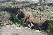 The canyons after the Escalante River.
 -
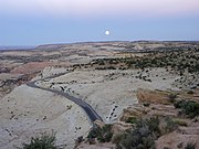 Moonrise over SR-12 in Grand Staircase–Escalante National Monument
 -
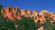 Red Canyon, in Utah's Dixie National Forest, is near the western end of Route 12.
 -
 An overlook from the eastern portion of Highway 12.
 -
 Calf Creek Canyon runs near Route 12.
 -
 The bridge on Hell's Backbone Road.
 -
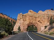 Red Canyon Scenic Drive.
 -
 State Route 12 in Utah - Panorama looking north and east from Head of the Rocks Overlook.


References
[edit]- ^ Jump up to: a b "Highway Reference Online - SR-12". maps.udot.utah.gov. Utah Department of Transportation. Jan 10, 2017. Retrieved September 16, 2021.
- ^ Long, Denise. PULL OVER! Roadside Attractions From Reno To Denver. Lulu.com. p. 12. ISBN 9781312241626.
- ^ "Utah National Highway System". UDOT Data Portal. Retrieved January 23, 2019.
- ^ "Traffic Statistics". udot.utah.gov. Utah Department of Transportation. 2005.
- ^ Jump up to: a b "State Road Resolutions SR-12.pdf". Utah Department of Transportation. (9.72 MB), updated September 2007, accessed May 2008
- ^ State Road Commission, Utah State Trunk Lines, 1923
- ^ Utah State Legislature (1927). "Chapter 21: Designation of State Roads". Session Laws of Utah.
12. From Hillsdale, about 7 miles south of Panguitch, southeasterly via Tropic Junction; to Bryce Canyon; also from Tropic Junction to Tropic.
- ^ Utah State Legislature (1931). "Chapter 55: Designation of State Roads". Session Laws of Utah.
(54) From Tropic junction on route 12 to Tropic." "(120) From Tropic southerly via Cannonville to Henrieville.
- ^ Utah State Legislature (1935). "Chapter 37: Designation of State Roads". Session Laws of Utah.
- ^ Utah Department of Transportation, State Route History Archived 2007-02-25 at the Wayback Machine. Retrieved July 2007.
- ^ Законодательное собрание штата Юта (1927). «Глава 21: Обозначение государственных дорог». Законы сессии Юты .
23. от восточного до Эскаланта.
- ^ Законодательное собрание штата Юта (1941). «Глава 34». Законы сессии Юты .
- ^ Законодательное собрание штата Юта (1947). «Глава 49». Законы сессии Юты .
Маршрут 54. От тропического соединения на маршруте 12 через Тропик, Кэннонвилл, Хенривилль и Эскаланте в Боулдер.
- ^ Законодательное собрание штата Юта (1931). «Глава 55: Обозначение государственных дорог». Законы сессии Юты .
(117) От развязки с маршрутом 24 к востоку от Бикнелла, на юге через Тайсдейл и Гровер.
- ^ "Road Resolutions SR-117.PDF" . Юта Департамент транспорта . (1,56 МБ) , обновлена в ноябре 2007 года, по состоянию на май 2008 г.
Внешние ссылки
[ редактировать ]- Карта и многое другое с сайта Dot American Byways
- Веб -сайт штата Юта для шоссе
- Историческая американская инженерная запись (Haer) № UT-83, « Туннель Красного Каньона, через Рок Фин на государственном шоссе 12, 5 миль к востоку от США 89, Пангуч, графство Гарфилд, UT », 3 фотографии, 1 цветная прозрачность, 2 фото Подпись страниц
- Haer No. UT-80, « Мост реки Эскаланте, охватывающий реку Эскаланте на штате 12, 9,5 миль к востоку от Эскаланте, Эскаланте, округ Гарфилд, UT », 11 фотографий, 16 страниц данных, 1 страница подписи.
- Всеамериканские дороги
- Национальный парк Брайс Каньон
- Национальный лес Дикси
- Национальный памятник Grand Staircase - Eccalante
- Историческая американская инженерная запись в Юте
- Достопримечательности в Юте
- Национальные лесные живописные дороги
- Национальные живописные дороги
- Государственные автомагистрали в Юте
- Штаты штат Юта в округе Гарфилд, штат Юта
- Юта живописные дороги
- Государственные маршруты штата Юта в округе Уэйн, штат Юта
- Туристические достопримечательности в округе Гарфилд, штат Юта
- Туристические достопримечательности в округе Уэйн, штат Юта