Jump to content

Deggendorf (district)

Coordinates: 48°50′N 13°00′E / 48.83°N 13°E / 48.83; 13
Deggendorf
Flag of Deggendorf
Coat of arms of Deggendorf
Map
CountryGermany
StateBavaria
Adm. regionLower Bavaria
CapitalDeggendorf
Government
 • District admin.Bernd Sibler (CSU)
Area
 • Total861 km2 (332 sq mi)
Population
 (31 December 2022)[1]
 • Total122,121
 • Density140/km2 (370/sq mi)
Time zoneUTC+01:00 (CET)
 • Summer (DST)UTC+02:00 (CEST)
Vehicle registrationDEG
Websitelandkreis-deggendorf.de

Deggendorf is a Landkreis (district) in Bavaria, Germany. It is bordered by (from the north and clockwise) the districts of Regen, Freyung-Grafenau, Passau, Rottal-Inn, Dingolfing-Landau and Straubing-Bogen.

History

[edit]

The district was established in 1936. Minor changes of the borders in 1972 led to the present form of the district.

Geography

[edit]

The Danube river runs through the district from west to east, dividing it into two unequal regions. North of the Danube the Bavarian Forest rises steeply. In the south there is relatively plain countryside. The Isar river enters the district in the south and meets the Danube close to the town of Deggendorf. The Einödriegel (1,220 m) is the highest point within the county.

Coat of arms

[edit]

The double eagle was the symbol of the monastery of Metten, which was the first Christian outpost in the region. The blue line stands for the river Danube, the green hills symbolise the Bavarian Forest.

Towns and municipalities

[edit]
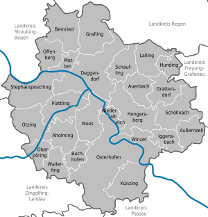
Dingolfing-LandauFreyung-GrafenauPassau (district)Regen (district)Rottal-InnStraubing-BogenAholmingAuerbachAußernzellBernriedBuchhofenDeggendorfGraflingGrattersdorfHengersbergHundingIggensbachKünzingLallingMettenMoosNiederalteichOberpöringOffenbergOsterhofenOtzingPlattlingSchauflingSchöllnachStephansposchingWallerfingWinzer
Clickable map of towns and municipalities in the district
TownsMunicipalities
  1. Deggendorf
  2. Osterhofen
  3. Plattling
  1. Aholming
  2. Auerbach
  3. Außernzell
  4. Bernried
  5. Buchhofen
  6. Grafling
  7. Grattersdorf
  8. Hengersberg
  9. Hunding
  10. Iggensbach
  11. Künzing
  1. Lalling
  2. Metten
  3. Moos
  4. Niederalteich
  5. Oberpöring
  6. Offenberg
  7. Otzing
  8. Schaufling
  9. Schöllnach
  10. Stephansposching
  11. Wallerfing
  12. Winzer

References

[edit]
[edit]

48°50′N 13°00′E / 48.83°N 13°E / 48.83; 13

Arc.Ask3.Ru: конец переведенного документа.
Arc.Ask3.Ru
Номер скриншота №: 06da87de6206f1a8542a585d32a28095__1710884100
URL1:https://arc.ask3.ru/arc/aa/06/95/06da87de6206f1a8542a585d32a28095.html
Заголовок, (Title) документа по адресу, URL1:
Deggendorf (district) - Wikipedia
Данный printscreen веб страницы (снимок веб страницы, скриншот веб страницы), визуально-программная копия документа расположенного по адресу URL1 и сохраненная в файл, имеет: квалифицированную, усовершенствованную (подтверждены: метки времени, валидность сертификата), открепленную ЭЦП (приложена к данному файлу), что может быть использовано для подтверждения содержания и факта существования документа в этот момент времени. Права на данный скриншот принадлежат администрации Ask3.ru, использование в качестве доказательства только с письменного разрешения правообладателя скриншота. Администрация Ask3.ru не несет ответственности за информацию размещенную на данном скриншоте. Права на прочие зарегистрированные элементы любого права, изображенные на снимках принадлежат их владельцам. Качество перевода предоставляется как есть. Любые претензии, иски не могут быть предъявлены. Если вы не согласны с любым пунктом перечисленным выше, вы не можете использовать данный сайт и информация размещенную на нем (сайте/странице), немедленно покиньте данный сайт. В случае нарушения любого пункта перечисленного выше, штраф 55! (Пятьдесят пять факториал, Денежную единицу (имеющую самостоятельную стоимость) можете выбрать самостоятельно, выплаичвается товарами в течение 7 дней с момента нарушения.)