Бетси река

| Бетси река | |
|---|---|
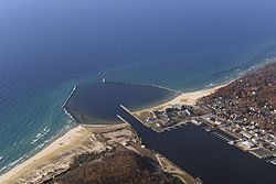 Устье реки Бетси на озере Мичиган , во Франкфорте | |
 Расположение устья | |
| Физические характеристики | |
| Источник | |
| • расположение | Зеленое озеро возле Интерлохена |
| • Координаты | 44 ° 35′31 . . ″ [ 1 ] |
| Mouth | |
• location | Lake Michigan at Frankfort |
• coordinates | 44°37′45″N 86°14′45″W / 44.6291652°N 86.2459287°W[1] |
| Length | 54 mi (87 km) |
Река Бетси ( / b ɛ t s iː / bet -see )-это 54,0 миль (86,9 км) [ 2 ] Река в штат Мичиган . США Река расположена на северо -западном нижнем полуострове штата, входящей в озеро Мичиган во Франкфурте . Курс реки в основном находится в графстве Бензи (который берет свое название из варианта произношения реки), хотя река поднимается в западном графстве Гранд Траверс и ненадолго течет через округ Северный Манист .
Река расширяется, чтобы сформировать озеро Бетси, прежде чем опустить озеро Мичиган между Франкфуртом и Эльбертой . Река Бетси является частью программы Мичиганского натуральных рек. [ 3 ]

Этимология
[ редактировать ]Название получено от французского La Rivière Aux Bec-Scies , то есть река уток Свельства ( Bec-Scie ). Коррупция этого произношения привела к названию округа Бензи . Другие альтернативные исторические названия включают следующее: [ 1 ]
- Au-Syn-Oons также
- У реки
- Река Бетси
- Бензи река
- Черная река
- Гей-капюшон
- Погода в Маркетте Ривиеер
- Sawbill Ducks River
- Shelldrake Ducks River
Course
[edit]While most sources indicate the river rises as the outflow of Green Lake in southwestern Grand Traverse County, some consider it navigable immediately south of US-31 from Tullers Lake into Green Lake. Another tributary of the river flows directly out of northern Duck Lake and into northern Green Lake, connecting with the aforementioned Tullers Lake Outlet. Although not considered part of the Betsie River today, older maps of the area do say so.[4] Green Lake straddles the boundary between Grant Township on the south and Green Lake Township on the north between Karlin and Interlochen. Several nearby lakes, including Duck Lake and its tributaries, drain into Green Lake.
The river winds southwesterly from Green Lake into eastern Benzie County, and then briefly into northern Manistee County before turning northerly back into Benzie County. A dam on the river forms Homestead Pond, after which is flows mostly west and slightly north to Lake Michigan.
Drainage basin
[edit]The Betsie River drains an area of approximately 155,026 acres (627.37 km2)[5] in three counties. The drainage basin include about 93 miles (150 km) of linear stream, 52 miles (84 km) of which is part of the mainstream.[6]
Dams
[edit]- Homestead Dam 44°35′48″N 86°04′48″W / 44.59667°N 86.08000°W[7] was mostly removed in 1974 and currently acts as a lamprey barrier. It impounds little water and does not impede salmon migrations.[5] The remains of the dam are now sometimes called "Homestead Falls".[8] The dam was a power generating facility formerly owned by Consumers Energy.[6]
- Grass Lake Dam, approximately 4 miles (6 km) downstream from Green Lake, forms an approximately 90-acre (36 ha) impoundment. The dam was constructed in 1951 to improve waterfowl habitat and northern pike fishing.[5] The dam was installed by the state Wildlife Division and created a 482 acres (195 ha) waterfowl flooding.[6]
- Thompsonville Dam was an old power dam[6] that failed in the spring of 1989 and was subsequently removed. Prior to its removal, the dam posed a barrier to salmon migration. Salmon and trout have access to the entire mainstream of the river, even above the Grass Lake Dam.[5]
Bridges
[edit]Below is a list of public crossings of the Betsie River:
Tributaries
[edit]- Betsie Lake 44°37′42″N 86°13′47″W / 44.62833°N 86.22972°W[9]
- Crystal Lake Outlet 44°37′32″N 86°08′18″W / 44.62556°N 86.13833°W[10]
- Rice Creek 44°36′19″N 86°06′51″W / 44.60528°N 86.11417°W[12]
- Dair Creek 44°33′05″N 86°03′15″W / 44.55139°N 86.05417°W[13]
- Little Betsie River 44°32′01″N 85°56′44″W / 44.53361°N 85.94556°W[14]
- Pickerel Creek 44°35′29″N 85°50′25″W / 44.59139°N 85.84028°W[15]
- Twin Lake 44°34′19″N 85°49′46″W / 44.57194°N 85.82944°W[16]
- Upper Twin Lake 44°34′19″N 85°49′17″W / 44.57194°N 85.82139°W[17]
- Grass Lake 44°36′30″N 85°51′03″W / 44.60833°N 85.85083°W[18]
- Mud Lake 44°34′31″N 85°47′55″W / 44.57528°N 85.79861°W[19]
- Green Lake 44°36′41″N 85°47′03″W / 44.61139°N 85.78417°W[20]
- Bridge Lake 44°38′21″N 85°47′07″W / 44.63917°N 85.78528°W[21]
- Tullers Lake 44°39′15″N 85°46′43″W / 44.65417°N 85.77861°W[22]
- Cedar Hedge Lake 44°40′12″N 85°47′04″W / 44.67000°N 85.78444°W[23]
- Mud Lake 44°38′36″N 85°45′28″W / 44.64333°N 85.75778°W[24]
- Duck Lake 44°37′53″N 85°44′42″W / 44.63139°N 85.74500°W[25]
- Horton Creek
- Brigham Creek 44°37′18″N 85°43′42″W / 44.62167°N 85.72833°W[26]
- Mason Creek 44°37′51″N 85°43′26″W / 44.63083°N 85.72389°W[27]
- Weidenhamer Swamp 44°37′35″N 85°36′10″W / 44.62639°N 85.60278°W[28]
- Tonawanda Lake 44°39′03″N 85°45′07″W / 44.65083°N 85.75194°W[29]
- Ellis Lake 44°39′47″N 85°44′54″W / 44.66306°N 85.74833°W[30]
- Saunders Lake 44°40′17″N 85°43′56″W / 44.67139°N 85.73222°W[31]
- Ellis Lake 44°39′47″N 85°44′54″W / 44.66306°N 85.74833°W[30]
Notes
[edit]- ^ Jump up to: a b c U.S. Geological Survey Geographic Names Information System: Betsie River
- ^ U.S. Geological Survey. National Hydrography Dataset high-resolution flowline data. The National Map Archived 2012-03-29 at the Wayback Machine, accessed November 21, 2011
- ^ Betsie River, Michigan Department of Natural Resources
- ^ LLC, Historic Map Works. "Blair - Left, Atlas: Grand Traverse County 1881, Michigan Historical Map". www.historicmapworks.com. Retrieved 2019-08-12.
- ^ Jump up to: a b c d Betsi River, Mark A. Tonello, "Status of the Fishery Resource Report, Michigan Department of Natural Resources, No. 2004-3, 2004
- ^ Jump up to: a b c d Betsie River Natural River Plan, Michigan Department of Natural Resources, July 1973, revised March 12, 2002
- ^ U.S. Geological Survey Geographic Names Information System: Homestead Dam
- ^ The Betsie River, Hanmer's Canoe Trips
- ^ U.S. Geological Survey Geographic Names Information System: Betsie Lake
- ^ U.S. Geological Survey Geographic Names Information System: Crystal Lake Outlet
- ^ U.S. Geological Survey Geographic Names Information System: Cold Creek
- ^ U.S. Geological Survey Geographic Names Information System: Rice Creek
- ^ U.S. Geological Survey Geographic Names Information System: Dair Creek
- ^ U.S. Geological Survey Geographic Names Information System: Little Betsie River
- ^ U.S. Geological Survey Geographic Names Information System: Pickerel Creek
- ^ U.S. Geological Survey Geographic Names Information System: Twin Lake
- ^ U.S. Geological Survey Geographic Names Information System: Upper Twin Lake
- ^ U.S. Geological Survey Geographic Names Information System: Grass Lake
- ^ U.S. Geological Survey Geographic Names Information System: Mud Lake
- ^ U.S. Geological Survey Geographic Names Information System: Green Lake
- ^ U.S. Geological Survey Geographic Names Information System: Bridge Lake
- ^ Геологические географические географические имена Информационная система: Туллерс озеро
- ^ Геологическая служба США Географические имена Информационная система: кедровое хедж -озеро
- ^ Геологическая служба США Географические названия Информационная система: Грязное озеро
- ^ Геологическая служба США Географические названия Информационная система: утиное озеро
- ^ Геологическая служба США Географические имена Информационная система: Бригам -Крик
- ^ Геологическая служба США Географические имена Информационная система: Мейсон -Крик
- ^ Геологическая служба США Географические имена Информационная система: Weidenhamer болото
- ^ Геологическая служба США Географические имена Информационная система: озеро Тонаванда
- ^ Геологическая служба США Географические имена Информационная система: Эллис Лэйк
- ^ Геологическая служба США Географические имена Информационная система: Сондерс озеро