Лонджи

Город Лонгджи
Город Лонгджи | |
|---|---|
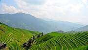
 Лонгджи рисовые террасы. | |
 Город Лонгджи Location in Guangxi | |
| Coordinates: 25°43′54″N 110°03′47″E / 25.73167°N 110.06306°E | |
| Country | China |
| Autonomous region | Guangxi |
| Prefecture | Guilin |
| Autonomous county | Longsheng Various Nationalities Autonomous County |
| Area | |
| • Total | 273.34 km2 (105.54 sq mi) |
| Population (2018) | |
| • Total | 16,000 |
| • Density | 59/km2 (150/sq mi) |
| Time zone | UTC+08:00 (China Standard) |
| Postal code | 541701 |
| Area code | 0773 |
Лонгджи ( упрощенный китайский : город Лонгджи ; традиционный китайский : город Лонгджи ; Пинин : Лойнгджи Чжэн ) - город в Лонгшенге различных национальностей автономного округа , Гуанси , Китай. [ 1 ] По состоянию на переписи 2018 года население составляло 16 000 человек и площадь 273,34 квадратных километра (105,54 кв. Миль). Лонгджи известен во всем мире для рисовых террасов Longsheng .

Административное разделение
[ редактировать ]По состоянию на 2016 год город разделен на пятнадцать деревень и одну общину:
- Heping Community (和平社区)
- Heping (和平村)
- Daliu (大柳村)
- Baishui (白水村)
- Yueqiao (岳武村)
- Bailing (摆岭村)
- Baishi (白石村)
- Jinjiang (金江村)
- Longji (龙脊村)
- Ping'an (平安村)
- Huangjiang (黄江村)
- Mahai (马海村)
- Zhongliu (中六村)
- Dazhai (大寨村)
- Xiaozhai (小寨村)
- Jiangliu (江柳村)
History
[edit]Longji came under the jurisdiction of Yining County (义宁县) in the Qing dynasty (1644–1911).
In 1916, it belonged to the South District (南区). In 1933, it was under the jurisdiction of Zhennan Township (镇南乡).
It known as Guanya Township (官衙乡) in May 1952 and renamed "Heping Township" on December 26 of that same year. On August 30, 1958, Heping Commune was founded and was revoked in August 1984. On January 2, 2014, it was upgraded to a town.
Geography
[edit]The town is situated at southeastern Longsheng Various Nationalities Autonomous County. The town is bordered to the north by Sishui Township, to the northeast by Jiangdi Township, to the south by Lingui District. to the southeast by Lingchuan County, and to the west by Longsheng Town.
The highest point in the town is Fupingbao (Chinese: 福平包) which stands 1,916.4 metres (6,287 ft) above sea level. The lowest point is Lipai (Chinese: 里排), which, at 238 metres (781 ft) above sea level.
The Heping Stream (和平河), a tributary of the Xun River, winds through the town.
Economy
[edit]Tourism is a significant part of the economy. The region abounds with gold.
Tourist attractions
[edit]The Longsheng Rice Terraces is a famous scenic spot in China.
Transportation
[edit]The China National Highway 321, commonly referred to as "G321", is a north–south highway passing through the town.
The G65 Baotou–Maoming Expressway, more commonly known as "Bao-Mao Expressway", runs north to south of the town.
Gallery
[edit]-
 Longsheng Rice Terraces
 -
 Longsheng Rice Terraces
 -
 Longsheng Rice Terraces
 -
 Longsheng Rice Terraces in November 2017.


Ссылки
[ редактировать ]- ^ Tonging 2007 , p. 13–21.
Библиография
[ редактировать ]- Ян Тонгинг, изд. (2007). "Административные подразделения" Административное разделение . "Обзор Longsheng автономный графство всех этнических групп" [ Общая ситуация Longsheng различные национальности автономного округа ] (по -китайски). Пекин: Национальный издательство. ISBN 978-7-105-08630-6 .