Pre-Pyrenees

| Pre-Pyrenees | |
|---|---|
 Montsec d'Ares, part of the Pyrenees Foothills | |
| Dimensions | |
| Length | 425 km (264 mi) E/W |
| Width | 40 km (25 mi) N/S |
| Geography | |
 Topographic map of the Pyrenees | |
| Countries | Spain and France |
| Range coordinates | 42°20′N 1°0′E / 42.333°N 1.000°E |
| Geology | |
| Orogeny | Alpine orogeny |

- Pyrenees
- Pre-Pyrenees
- Catalan Central Depression
- Smaller mountain ranges of the Central Depression
- Catalan Transversal Range
- Catalan Pre-Coastal Range
- Catalan Coastal Range
- Catalan Coastal Depression and other coastal and pre-coastal plains
The Pre-Pyrenees are the foothills of the Pyrenees.
Description
[edit]As a mountainous system the Pre-Pyrenees are part of the Pyrenees. They run parallel to the main mountain range in a west to east direction.
On the French side the Pyrenees's slopes descend rather abruptly, thus on the northern side, the Pre-Pyrenees are confined to the Corbières Massif, towards the eastern end of the mountain system.[1] The Massif de Plantaurel further west deserves mention as well, although not as clearly a foothill.
On the Iberian side, however, the picture is very different: a large and complex system of foothill ranges stretches from Navarre, across northern Aragon, reaching the Mediterranean coast on the Catalan end of the Pyrenees. At the eastern end on the southern side lies a distinct area known as the Sub-Pyrenees.[2]
Main ranges
[edit]Although the highest peaks in the Pre-Pyrenees are not as high as those in the Pyrenees proper, some of the ranges are quite massive, with summits reaching up to 2,600 m (8,500 ft).[3]
Northern slope
[edit]Southern slope
[edit]The main ranges are:
- In Catalonia
- Serra d'Aubenç
- Serra dels Bastets
- Serra de Bellmunt
- Cingles de Beví
- Serra de Boumort
- Serra de Busa
- Serra del Cadí
- Serra de Boumort
- Serra de Camporan
- Serra de les Canals
- Serra de Capsacosta
- Serra de Carreu
- El Catllaràs
- Serra de Comiols
- Serra del Port del Comte
- Serra de Conivella
- Serrat de la Creueta
- Serra d'Ensija
- La Faiada de Malpàs
- Serra de Falgars
- Serra de la Gessa
- Serra de Sant Mamet
- Serra de Moixeró
- Serra de Milany
- Mare de Déu del Mont
- Serra de Monebui
- Serra de Montclús
- Montsec range
- Montsec de Rúbies, the eastern massif, is separated by the river Segre in the east and the Noguera Pallaresa in the middle.
- Montsec d'Ares, the central massif.
- Montsec d'Estall, in Aragon, located to the west, separated by the Noguera Ribagorçana from the central massif.
- Serra de Montgrony
- Serra de Prada
- Serra de Picamill
- Serra de Picancel
- Serra de Queralt
- Serra de Sant Gervàs
- Serra de Sant Joan
- Serra de Sant Marc
- Serra de serra de Sobremunt
- Serra del Volterol
- Serra dels Tossals
- Serra de Turp
- Rasos de Peguera
- In Aragon
- Sierra Caballera
- Sierra del Castillo de Llaguarres
- Sierra de la Carrodilla
- Cotiella
- Serra d'Esdolomada[4]
- Sierra Ferrera
- Sierra de Giró
- Serra del Jordal
- Sierra de las Ares
- Sierra de Guara
- El Turbón
- Sierra de Sis
- Sierra de Santo Domingo
- Sierra de Loarre
- Sierra de Javierre
- Sierra Caballera
- In Navarre
Features
[edit]

 Summits of the Corbières Massif, the only foothill of the Pyrenees on their northern side
 View of Serra del Cadí
 View of Serra Ferrera
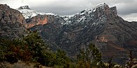 View of the Mountains of Sis
 View of Serra del Jordal


See also
[edit]References
[edit]- ^ Christophe Neff : Les Corbières maritimes – forment-elles un étage de végétation méditerranéenne thermophile masqué par la pression humaine ? In: Eric Fouache (Edit.): The Mediterranean World Environment and History. IAG Working Group on Geo-archeology, Symposium Proceedings. Environmental Dynamics and History in Mediterranean Areas, Paris, Université de Paris – Sorbonne 24 – 26 avril 2002. Paris, 2003, 191 – 202, (Elsevier France, ISBN 2-84299-452-3).
- ^ Jordi Sacasas i Lluís, Geografía de Catalunya, Publicacions L'Abadia de Montserrat. ISBN 978-84-8415-915-5
- ^ Pirineus-Prepirineus Archived 2008-07-23 at the Wayback Machine
- ^ Luis Javier Cruchaga, Turbón y Sierra de Sis,Mapas excursionistas, no 12 PRAMES 2002 ISBN 84-8321-123-8
External links
[edit] Media related to Pre-Pyrenees at Wikimedia Commons